Petrovice (Bruntál District)
Petrovice | |
|---|---|
Village and Municipality | |
 Petrovice | |
 Flag  Coat of arms | |
 Location in the Czech Republic | |
| Coordinates: 50°13′48″N 17°26′29″E / 50.23°N 17.4414°ECoordinates: 50°13′48″N 17°26′29″E / 50.23°N 17.4414°E | |
| Country | |
| Region | Moravian-Silesian Region |
| District | Bruntál District |
| Area | |
| • Total | 4.27 sq mi (11.05 km2) |
| Elevation | 1,540 ft (470 m) |
| Population (2011) | |
| • Total | 142 |
| • Density | 33/sq mi (13/km2) |
| Time zone | UTC+1 (CET) |
| • Summer (DST) | UTC+2 (CEST) |
| Postal code | 793 84 |

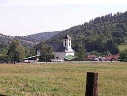
Petrovice (German: Petersdorf) is a village and municipality in Bruntál District in the Moravian-Silesian Region of the Czech Republic. Petrovice is a village conservation area and its rural character make it a popular holiday destination.[1] The village population is 131.
Location[]
Petrovice is located in the west of Czech Republic near its border with Poland (the border is approximately 2 kilometres (1.2 mi) north of the village). The national capital, Prague, lies approximately 200 kilometres (120 mi) to the west. Although Petrovice is in the Moravian-Silesian Region it shares its western border with the Olomouc Region. Petrovice is on the 457 road from Janov to Zlate Hory.[2]
Geography[]
Petrovice is located in the most western and mountainous part of the Osoblažsko microregion in the Petrovický stream valley. The mountains of Zlatohorská upland rise steeply from the banks of the stream to reach 900 metres (3,000 ft) in height. The peak of Biskupska kupa (Bishop's Hill) is approximately 3 kilometres (1.9 mi) to the northwest of the village. The village, which rests along the eastern bank of the Osoblaha stream, is immediately surrounded by green terraced fields and forests.[2]
Petrovice viewing tower[]

The Petrovice viewing tower, the oldest stone tower in the Jeseníky mountains, is located on mount Biskupská kupa and is 18 metres (59 ft) high. It was built in 1898 by the German tourist association, MSSGV, to commemorate 50 years of the reign of Franz Joseph I. The tower was closed to the public after World War II and was then used as a television transmitter. In 1996, reconstruction and restoration began on the tower before its opening to the public on its centenary in 1998. Since 2006, the tower has housed a post office. In good weather, one can see Wroclaw and the peaks of High Tatras in Slovakia.
Architecture[]
Petrovice village contains examples of folk architecture, such as country houses (numbered 39, 115, 130 and 137). The village is dominated by the single-aisle Church of St. Roch, built in the late 1600s CE.
Nearby attractions[]
Petrovice has facilities for skiers that include a ski lift at the end of the village. Heřmanovice municipality is a protected conservation village because of a uniquely preserved complex of Jeseníky residential folk architecture of the Eastern Sudeten type. The town of Zlaté Hory has an outdoor mining museum (Zlatorudné mills), as well as a ski resort below mount Příčná hora.
Notable people from Petrovice[]
- Josef Pfitzner - Sudeten German historian, writer, Nazi politician, and Standartenführer in the SA who was executed for war crimes
References[]
- ^ "Památkové rezervace a zóny Moravskoslezského kraje." Archived 2012-09-27 at the Wayback Machine Accessed 2 December 2012.
- ^ Jump up to: a b "Petrovice, Czech Republic." Google Maps, 14 February 2014.
| Wikimedia Commons has media related to Petrovice (Bruntál District). |
| Authority control: National libraries |
|---|
- Populated places in Bruntál District
- Villages in Bruntál District