Kenbridge, Virginia
Kenbridge, Virginia | |
|---|---|
Town | |
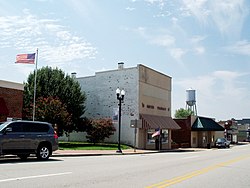 Central Kenbridge | |
 Location in Virginia | |
| Coordinates: 36°57′46″N 78°7′37″W / 36.96278°N 78.12694°WCoordinates: 36°57′46″N 78°7′37″W / 36.96278°N 78.12694°W | |
| Country | United States |
| State | Virginia |
| County | Lunenburg |
| Founded | 1908 |
| Government | |
| • Mayor | Emory Hodges |
| Area | |
| • Total | 2.31 sq mi (5.97 km2) |
| • Land | 2.31 sq mi (5.97 km2) |
| • Water | 0.00 sq mi (0.00 km2) |
| Elevation | 515 ft (157 m) |
| Population (2010) | |
| • Total | 1,257 |
| • Estimate (2019)[4] | 1,197 |
| • Density | 519.31/sq mi (200.47/km2) |
| Time zone | UTC-5 (Eastern (EST)) |
| • Summer (DST) | UTC-4 (EDT) |
| ZIP code | 23944 |
| Area code(s) | 434 |
| FIPS code | 51-41832[2] |
| GNIS feature ID | 1495781[3] |
| Website | kenbridgeva |

Kenbridge is a town in Lunenburg County, Virginia, United States. The population was 1,257 at the 2010 census. It is in a tobacco farming area. The area is home to noted folk artist Eldridge Bagley.
Geography[]
Kenbridge is located at 36°57′46″N 78°7′37″W / 36.96278°N 78.12694°W (36.962805, -78.126896).[5]
According to the United States Census Bureau, the town has a total area of 2.0 square miles (5.3 km²), all of it land.
Brickland, the Fifth Avenue Historic District, Flat Rock, and the Jones Farm are listed on the National Register of Historic Places.[6]
Demographics[]
| Historical population | |||
|---|---|---|---|
| Census | Pop. | %± | |
| 1910 | 196 | — | |
| 1920 | 543 | 177.0% | |
| 1930 | 753 | 38.7% | |
| 1940 | 847 | 12.5% | |
| 1950 | 1,176 | 38.8% | |
| 1960 | 1,188 | 1.0% | |
| 1970 | 1,223 | 2.9% | |
| 1980 | 1,352 | 10.5% | |
| 1990 | 1,264 | −6.5% | |
| 2000 | 1,253 | −0.9% | |
| 2010 | 1,257 | 0.3% | |
| 2019 (est.) | 1,197 | [4] | −4.8% |
| U.S. Decennial Census[7] | |||
At the 2000 census there were 1,253 people, 529 households, and 320 families living in the town. The population density was 614.6 people per square mile (237.1/km²). There were 579 housing units at an average density of 284.0 per square mile (109.6/km²). The racial makeup of the town was 51.56% White, 44.93% African American, 0.40% Asian, 1.28% from other races, and 1.84% from two or more races. Hispanic or Latino of any race were 4.39%.[2]
Of the 529 households 20.8% had children under the age of 18 living with them, 38.9% were married couples living together, 15.9% had a female householder with no husband present, and 39.5% were non-families. 35.7% of households were one person and 19.1% were one person aged 65 or older. The average household size was 2.24 and the average family size was 2.83.
The age distribution was 21.9% under the age of 18, 9.8% from 18 to 24, 23.0% from 25 to 44, 25.9% from 45 to 64, and 19.4% 65 or older. The median age was 41 years. For every 100 females there were 101.1 males. For every 100 females age 18 and over, there were 99.0 males.
The median income for a household in the town was $26,818, and the median family income was $38,929. Males had a median income of $22,083 versus $18,456 for females. The per capita income for the town was $15,386. About 11.4% of families and 18.8% of the population were below the poverty line, including 27.8% of those under age 18 and 18.7% of those age 65 or over.
References[]
- ^ "2019 U.S. Gazetteer Files". United States Census Bureau. Retrieved August 7, 2020.
- ^ Jump up to: a b "U.S. Census website". United States Census Bureau. Retrieved 2008-01-31.
- ^ "US Board on Geographic Names". United States Geological Survey. 2007-10-25. Retrieved 2008-01-31.
- ^ Jump up to: a b "Population and Housing Unit Estimates". United States Census Bureau. May 24, 2020. Retrieved May 27, 2020.
- ^ "US Gazetteer files: 2010, 2000, and 1990". United States Census Bureau. 2011-02-12. Retrieved 2011-04-23.
- ^ "National Register Information System". National Register of Historic Places. National Park Service. July 9, 2010.
- ^ "Census of Population and Housing". Census.gov. Retrieved June 4, 2015.
| show Municipalities and communities of Lunenburg County, Virginia, United States |
|---|

| show |
|---|
| show Authority control |
|---|
- Towns in Lunenburg County, Virginia