White Stone, Virginia
White Stone, Virginia | |
|---|---|
Town | |
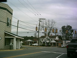 Central White Stone | |
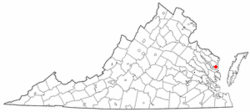 Location of White Stone, Virginia | |
| Coordinates: 37°38′43″N 76°23′28″W / 37.64528°N 76.39111°WCoordinates: 37°38′43″N 76°23′28″W / 37.64528°N 76.39111°W | |
| Country | United States |
| State | Virginia |
| County | Lancaster |
| Area | |
| • Total | 0.98 sq mi (2.54 km2) |
| • Land | 0.98 sq mi (2.53 km2) |
| • Water | 0.00 sq mi (0.01 km2) |
| Elevation | 49 ft (15 m) |
| Population (2010) | |
| • Total | 352 |
| • Estimate (2019)[4] | 331 |
| • Density | 338.45/sq mi (130.64/km2) |
| Time zone | UTC−5 (Eastern (EST)) |
| • Summer (DST) | UTC−4 (EDT) |
| ZIP code | 22578 |
| Area code(s) | 804 |
| FIPS code | 51-85600[2] |
| GNIS feature ID | 1476645[3] |

White Stone is a town in Lancaster County, Virginia, United States. The population was 352 at the 2010 census. The name "White Stone" refers to the accumulations of white stones in the area's waterways. The stones were dumped there in the colonial era by British ships that dumped their stone ballast to make room for cargo like tobacco to carry back to England.
History[]
Pop Castle was listed on the National Register of Historic Places in 1989.[5]
Geography[]
White Stone is located at 37°38′43″N 76°23′28″W / 37.64528°N 76.39111°W (37.645182, −76.391242).[6]
According to the United States Census Bureau, the town has a total area of 1.0 square miles (2.6 km2), all of it land.
Demographics[]
| Historical population | |||
|---|---|---|---|
| Census | Pop. | %± | |
| 1960 | 395 | — | |
| 1970 | 381 | −3.5% | |
| 1980 | 409 | 7.3% | |
| 1990 | 372 | −9.0% | |
| 2000 | 358 | −3.8% | |
| 2010 | 352 | −1.7% | |
| 2019 (est.) | 331 | [4] | −6.0% |
| U.S. Decennial Census[7] | |||
As of the census[2] of 2000, there were 358 people, 163 households, and 101 families living in the town. The population density was 362.1 people per square mile (139.6/km2). There were 187 housing units at an average density of 189.2 per square mile (72.9/km2). The racial makeup of the town was 86.31% White, 10.34% African American, 2.23% Asian, 0.28% from other races, and 0.84% from two or more races. Hispanic or Latino of any race were 0.84% of the population.
There were 163 households, out of which 27.0% had children under the age of 18 living with them, 52.1% were married couples living together, 8.0% had a female householder with no husband present, and 38.0% were non-families. 32.5% of all households were made up of individuals, and 22.1% had someone living alone who was 65 years of age or older. The average household size was 2.20 and the average family size was 2.73.
In the town, the population was spread out, with 19.8% under the age of 18, 7.0% from 18 to 24, 25.4% from 25 to 44, 26.0% from 45 to 64, and 21.8% who were 65 years of age or older. The median age was 42 years. For every 100 females, there were 88.4 males. For every 100 females age 18 and over, there were 82.8 males.
The median income for a household in the town was $28,125, and the median income for a family was $31,875. Males had a median income of $31,500 versus $22,000 for females. The per capita income for the town was $17,835. About 6.7% of families and 13.9% of the population were below the poverty line, including 24.7% of those under age 18 and 20.3% of those age 65 or over.
References[]
- ^ "2019 U.S. Gazetteer Files". United States Census Bureau. Retrieved August 7, 2020.
- ^ Jump up to: a b "U.S. Census website". United States Census Bureau. Retrieved 2008-01-31.
- ^ "US Board on Geographic Names". United States Geological Survey. 2007-10-25. Retrieved 2008-01-31.
- ^ Jump up to: a b "Population and Housing Unit Estimates". United States Census Bureau. May 24, 2020. Retrieved May 27, 2020.
- ^ "National Register Information System". National Register of Historic Places. National Park Service. July 9, 2010.
- ^ "US Gazetteer files: 2010, 2000, and 1990". United States Census Bureau. 2011-02-12. Retrieved 2011-04-23.
- ^ "Census of Population and Housing". Census.gov. Retrieved June 4, 2015.
External links[]
| show Municipalities and communities of Lancaster County, Virginia, United States |
|---|

| show |
|---|
| show Authority control |
|---|
- Towns in Lancaster County, Virginia
- Towns in Virginia