Kentucky's congressional districts

Kentucky is currently divided into 6 congressional districts, each represented by a member of the United States House of Representatives. The number of congressional districts has been set at 6 since the 1990 redistricting cycle.
Current (until 2023 inauguration) districts and representatives[]
This is a list of members of the current Kentuckian House delegation, their terms, their district boundaries, and the districts' political ratings according to the Cook Partisan Voting Index (CPVI). The delegation has a total of six members, including five Republicans and one Democrat.
| Current U.S. representatives from Kentucky ()
| |||||
|---|---|---|---|---|---|
| District | Member (Residence)[2] |
Party | Incumbent since | CPVI (2021)[3] |
District map |
| 1st |  James Comer (Tompkinsville) |
Republican | November 8, 2016 | R+26 | 
|
| 2nd |  Brett Guthrie (Bowling Green) |
Republican | January 3, 2009 | R+22 | 
|
| 3rd |  John Yarmuth (Louisville) |
Democratic | January 3, 2007 | D+8 | 
|
| 4th |  Thomas Massie (Garrison) |
Republican | November 13, 2012 | R+19 | 
|
| 5th |  Hal Rogers (Somerset) |
Republican | January 3, 1981 | R+33 | 
|
| 6th |  Andy Barr (Lexington) |
Republican | January 3, 2013 | R+8 | 
|
Historical and present district boundaries[]
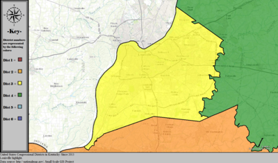
Table of United States congressional district boundary maps in the State of Kentucky, presented chronologically.[4] All redistricting events that took place in Kentucky between 1973 and 2013 are shown.

| Year | Statewide map | Louisville highlight |
|---|---|---|
| 1973–1982 | 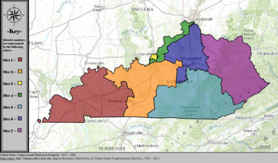
|

|
| 1983–1992 | 
|

|
| 1993–1996 | 
|

|
| 1997–2002 | 
|
|
| 2003–2013 | 
|

|
| Since 2013 | 
|
|
Obsolete districts[]
The following are former districts of Kentucky:
- 7th district, obsolete since 1993
- 8th district, obsolete since 1963
- 9th district, obsolete since 1953
- 10th district, obsolete since 1933
- 11th district, obsolete since 1933
- 12th district, obsolete since 1843
- 13th district, obsolete since 1843
- At-large district, obsolete since 1935
See also[]
References[]
- ^ "The national atlas". nationalatlas.gov. Archived from the original on February 22, 2014. Retrieved February 2, 2014.
- ^ "Office of the Clerk, U.S. House of Representatives". clerk.house.gov. Retrieved 2022-01-06.
- ^ "Introducing the 2021 Cook Political Report Partisan Voter Index". Cook Political Report. Retrieved 2022-01-06.
- ^ "Digital Boundary Definitions of United States Congressional Districts, 1789–2012". Retrieved October 18, 2014.
- Politics of Kentucky
- Congressional districts of Kentucky