Kinnear's Mills, Quebec
Kinnear's Mills | |
|---|---|
Municipality | |
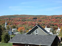 View of the village from the main route. | |
 Location within Les Appalaches RCM | |
 Kinnear's Mills Location in province of Quebec | |
| Coordinates: 46°13′N 71°23′W / 46.22°N 71.38°WCoordinates: 46°13′N 71°23′W / 46.22°N 71.38°W[1] | |
| Country | |
| Province | |
| Region | Chaudière-Appalaches |
| RCM | Les Appalaches |
| Constituted | July 1, 1855 |
| Government | |
| • Mayor | Paul Vachon |
| • Federal riding | Mégantic—L'Érable |
| • Prov. riding | Lotbinière-Frontenac |
| Area | |
| • Total | 93.10 km2 (35.95 sq mi) |
| • Land | 94.09 km2 (36.33 sq mi) |
| There is an apparent contradiction between two authoritative sources | |
| Population | |
| • Total | 369 |
| • Density | 3.9/km2 (10/sq mi) |
| • Pop 2006-2011 | |
| • Dwellings | 175 |
| Time zone | UTC−5 (EST) |
| • Summer (DST) | UTC−4 (EDT) |
| Postal code(s) | G0N 1K0 |
| Area code(s) | 418 and 581 |
| Highways | |
| Website | www |

Kinnear's Mills is a municipality located in the Les Appalaches Regional County Municipality in the Chaudière-Appalaches region of Quebec, Canada. Its population was 369 as of the Canada 2011 Census. It is known as the "Village of Churches," as four churches (Anglican, Catholic, Methodist, and United) are located close to each other in the village centre.
James G. Kinnear (1924 - 2010 ) published a book, "Kinnear's Mills," documenting the creation of the village and the family of James Kinnear, after whom the municipality is named.
Gallery[]


References[]
- ^ Reference number 144349 of the Commission de toponymie du Québec (in French)
- ^ Jump up to: a b Geographic code 31105 in the official Répertoire des municipalités (in French)
- ^ Jump up to: a b "(Code 2431105) Census Profile". 2011 census. Statistics Canada. 2012.
External links[]
 Media related to Kinnear's Mills at Wikimedia Commons
- Kinnear's Mills' website
- Kinnear's Mills Heritage Site
| show Places adjacent to Kinnear's Mills, Quebec |
|---|
| show |
|---|
| Authority control |
|
|---|
Categories:
- Municipalities in Quebec
- Incorporated places in Chaudière-Appalaches