Kohima
Kohima | |
|---|---|
Clockwise From Top: Kohima skyline, Aradurah Hill, P.R. Hill Junction, KABA Building | |
 | |
 Kohima Location of Kohima in Nagaland | |
| Coordinates: 25°40′12″N 94°06′28″E / 25.6701°N 94.1077°ECoordinates: 25°40′12″N 94°06′28″E / 25.6701°N 94.1077°E | |
| Country | |
| State | |
| District | Kohima |
| Government | |
| • Type | Municipality |
| • Body | Kohima Municipal Council |
| • Chairman | Kovi Meyase |
| Area | |
| • Total | 20 km2 (8 sq mi) |
| Elevation | 1,444 m (4,738 ft) |
| Population (2011) | |
| • Total | 115,283[1] |
| Demonym(s) | Kohimian kewhi–mia |
| Languages | |
| • Official | English |
| • Major dialects | Angami • Ao • Chakhesang • Lotha • Sümi |
| Time zone | UTC+5:30 (IST) |
| PIN | 797001 |
| Telephone code | 91 (0)370 |
| Vehicle registration | NL-01 |
| Sex ratio | 927 ♂/♀ |
| Climate | Temperate (Köppen) |
| Website | kohima |


Kohima (/koʊˈhiːmə/ ![]() pronunciation (help·info)) is the capital city of India's north eastern state of Nagaland. With a resident population of almost 100,000, it is the second largest city in the state.[1] Originally known as Kewhira, Kohima was founded in 1878 when the British Empire established its headquarters of the then Naga Hills District of Assam Province. It officially became the capital after the state of Nagaland was inaugurated in 1963. Kohima was the site of one of the bloodiest battles of World War II. The battle is often referred to as the ‘Stalingrad of the East’.[2][3] In 2013, the British National Army Museum voted the Battle of Kohima to be ‘Britain's Greatest Battle’.[4]
pronunciation (help·info)) is the capital city of India's north eastern state of Nagaland. With a resident population of almost 100,000, it is the second largest city in the state.[1] Originally known as Kewhira, Kohima was founded in 1878 when the British Empire established its headquarters of the then Naga Hills District of Assam Province. It officially became the capital after the state of Nagaland was inaugurated in 1963. Kohima was the site of one of the bloodiest battles of World War II. The battle is often referred to as the ‘Stalingrad of the East’.[2][3] In 2013, the British National Army Museum voted the Battle of Kohima to be ‘Britain's Greatest Battle’.[4]
Kohima constitutes both a district and a municipality. The municipality covers 20 km2 (7.7 sq mi). Kohima lies on the foothills of Japfü range located south of the District (25°40′N 94°07′E / 25.67°N 94.12°E)[5] and has an average elevation of 1,261 metres (4137 feet).[6]
Etymology[]
Kohima was originally known as Kewhi–ra.[7] The name, Kohima, was officially given by the British as they could not pronounce the Angami name of Kewhi–ra (Tenyidie for "the land where the flower ‘Kewhi’ grows"). It is called after the wild flowering plant ‘Kewhi’, found in the mountains. Most local people prefer to use ‘Kewhi–ra’.
History[]
Kohima was originally a large village named Kewhira, which is located in the northeastern part of the present day Kohima urban area. The village is divided into four large clans (thinuo): Tsütuonuomia, Lhisemia, Dapfütsumia and Pfuchatsumia (T, L, D, and P Khel respectively).
Colonial era[]
The East India Company administration started to expand into Kohima beginning the 1840's.[8] The progress made by the company armies in annexing the region continued after the Indian Rebellion of 1857, although now under the auspices of the British Indian Army. Kohima was the first seat of modern administration as the Headquarters of Naga Hills District (then under Assam) with the appointment of Guybon Henry Damant as Political Officer in 1879.[citation needed]
Battle of Kohima[]

In 1944 during the Second World War the Battle of Kohima along with the simultaneous Battle of Imphal was the turning point in the Burma Campaign.[9] For the first time in South-East Asia, the Japanese lost the initiative to the Allies, which the Allies then retained, until the end of the war. This hand-to-hand battle and slaughter prevented the Japanese Army from gaining a base from which they might have easily gone into the plains of India.[10]
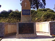
Kohima has a large cemetery known as the War Cemetery in Kohima for the Allied war dead maintained by the Commonwealth War Graves Commission. The cemetery lies on the slopes of Garrison Hill, in what was once the Deputy Commissioner's tennis court which was the scene of intense fighting, the Battle of the Tennis Court. The epitaph carved on the memorial of the 2nd British Division in the cemetery has become world-famous as the Kohima poem.
When You Go Home, Tell Them Of Us And Say,
For Your Tomorrow, We Gave Our Today.
The verse is attributed to John Maxwell Edmonds (1875–1958), and is thought to have been inspired by the epitaph written by Simonides to honour the Greek who fell at the Battle of Thermopylae in 480 BC.[11]
1947–present[]
When Nagaland became a full-fledged state on 1 December 1963, Kohima was christened as the state capital.[12]
On 20 March 1986, two students Kekuojalie Sachü and Vikhozo Yhoshü were killed in indiscriminate firing by Nagaland Police when they participated in a peaceful protest called by the Naga Students' Federation (NSF) to rally against the state government's decision on the introduction of Indian Police Service (IPS) cadres and the extension of the Disturbed Area Belt from 5 to 20 km along the Indo-Myanmar (Indo-Burma) border. The event was so tumultuous that it led three Cabinet ministers and five state ministers of Nagaland to resign.[13]
Geography[]
Kohima lies north of the Japfü Barail intersection.[citation needed]
Climate[]
The city experiences the subtropical highland climate (Köppen: Cwb), with greater contrast between summer and winter than in other continents due to the monsoons and mild temperatures even for latitude and altitude. The months of June to September concentrate much of the precipitation.[14]
Kohima has cool winters with rarefied rain sometimes warm (but not hot) and very rainy summers. The coldest months are from December to February, when frost occurs and in the higher altitudes snowfall occurs occasionally. During the height of summers, from June–August, temperature ranges an average of 27–32 °C (80–90 °F). Heavy rainfall occurs during summer.[citation needed]
| hide | |||||||||||||
|---|---|---|---|---|---|---|---|---|---|---|---|---|---|
| Month | Jan | Feb | Mar | Apr | May | Jun | Jul | Aug | Sep | Oct | Nov | Dec | Year |
| Record high °C (°F) | 24.5 (76.1) |
25.0 (77.0) |
29.1 (84.4) |
32.2 (90.0) |
33.9 (93.0) |
30.5 (86.9) |
33.1 (91.6) |
31.1 (88.0) |
31.0 (87.8) |
31.5 (88.7) |
29.5 (85.1) |
26.0 (78.8) |
33.9 (93.0) |
| Average high °C (°F) | 15.5 (59.9) |
17.7 (63.9) |
21.7 (71.1) |
23.8 (74.8) |
23.8 (74.8) |
24.7 (76.5) |
25.1 (77.2) |
25.3 (77.5) |
24.8 (76.6) |
23.7 (74.7) |
20.7 (69.3) |
17.9 (64.2) |
22.1 (71.8) |
| Daily mean °C (°F) | 11.6 (52.9) |
13.4 (56.1) |
17.3 (63.1) |
19.6 (67.3) |
20.4 (68.7) |
21.6 (70.9) |
21.5 (70.7) |
21.6 (70.9) |
21.3 (70.3) |
20.1 (68.2) |
16.6 (61.9) |
13.4 (56.1) |
18.2 (64.8) |
| Average low °C (°F) | 8.0 (46.4) |
9.3 (48.7) |
11.2 (52.2) |
15.0 (59.0) |
16.6 (61.9) |
17.8 (64.0) |
18.7 (65.7) |
18.9 (66.0) |
17.9 (64.2) |
16.7 (62.1) |
13.1 (55.6) |
9.2 (48.6) |
14.5 (58.1) |
| Record low °C (°F) | 0.6 (33.1) |
2.3 (36.1) |
4.0 (39.2) |
5.0 (41.0) |
8.3 (46.9) |
9.4 (48.9) |
7.8 (46.0) |
8.3 (46.9) |
8.9 (48.0) |
5.0 (41.0) |
3.1 (37.6) |
2.2 (36.0) |
0.6 (33.1) |
| Average rainfall mm (inches) | 9.6 (0.38) |
24.0 (0.94) |
48.4 (1.91) |
92.2 (3.63) |
133.4 (5.25) |
323.6 (12.74) |
363.3 (14.30) |
360.7 (14.20) |
228.6 (9.00) |
134.8 (5.31) |
32.5 (1.28) |
5.8 (0.23) |
1,756.9 (69.17) |
| Average rainy days | 1.2 | 2.5 | 4.5 | 8.3 | 12.2 | 19.0 | 22.1 | 19.3 | 16.4 | 9.1 | 2.3 | 0.6 | 117.5 |
| Average relative humidity (%) | 74 | 67 | 65 | 70 | 77 | 85 | 88 | 88 | 86 | 83 | 76 | 71 | 78 |
| Source: India Meteorological Department[15][16] | |||||||||||||
Environment[]
Water supply and availability[]
Most Wards in Kohima experiences severe water shortages during the dry seasons. The current water resources from the reservoirs of Zarü River and the streams from the slopes of Pulie Badze do not fulfill the needs of the rapidly growing population of Kohima. With the augmentation of the Zarü River project and several other upcoming water projects to be supplied from Dzüko Valley and others. The water supply is expected to cover more wards.[17]
Administration[]
The Kohima Municipal Council (KMC) was established in 2005 under India's Constitution (Seventy-Fourth Amendment) Act, 1992. It has waste management, drainage and trade licensing and other responsibilities.[18][19]
Other departments of the state government, which sit in Kohima, also have a role in the administration of Kohima.[19] The "City Development Plan" for the town, for example, was written by state Urban Development Department.[20]
Greater Kohima planning area[]
The Greater Kohima Planning Area (GKPA) comprises the KMC plus Kohima, Meriema, Tsiesema and Thizama villages and their peripheral, cultivable and conservation areas, and the "Capital Complex Area". The total area of the GKPA is 63.36 sq km, of which municipal council's 11 sq km accounts for just over 17%.[20][21][19]
Demographics[]
Religion in Kohima City (2011)[22]
As of 2011, Kohima had a population of 99,039 of which males and females were 51,626 and 47,413 respectively. Kohima has an average literacy rate of 90.76%, higher than the national average of 79.55%.[1]
The city's population is composed of the 16 tribes of Nagaland. The population of the Angamis, Aos and Lothas are the largest in present-day Kohima urban area.
The major religion in Kohima is Christianity which is practised by 80.22% of the population. Other religions includes Hinduism (16.09%), Islam (3.06%) and Buddhism (0.45%).[22]
As of 2011 six of Kohima's nineteen wards, covering 26% of the town, have been designated as slums, within which about a third of the population was Below Poverty Line.[20]
The Greater Kohima planning area had a population of 115,283 at the 2001 census, of which the KMC area accounted for 67% and Kohima Village 16%.[20]
Cityscape[]
Historical sites[]
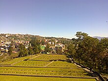
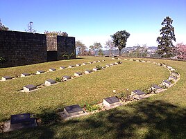
- Kohima War Cemetery
Kohima War Cemetery is a memorial dedicated to soldiers of the 2nd British Division of the Allied Forces who died in the Second World War at Kohima in April 1944. There are 1,420 Commonwealth burials of the Second World War at this cemetery.
Parks[]
- Sakhrie Park
Sakhrie Park is a recreational park located at Middle A.G Ward located between the Asian Highway 1 and the A.G Road.
Culture[]
Religious sites[]

The Mary Help of Christians Cathedral or commonly known as the Kohima Cathedral is a prominent landmark in Kohima. The 16 feet high carved wood crucifix is one of Asia's largest crosses. It is the biggest Catholic church in Nagaland and was constructed in 1998.
There are numerous Protestant churches in Kohima. Kohima Ao Baptist Church and Kohima Lotha Baptist Church are some of the biggest churches in Kohima.
The Kohima Jain Temple, the oldest Jain temple in North East India was established in 1920.
Events and Festivals[]

- NAJ Cosfest
The NAJ Cosfest is an Otaku-based cosplay festival held every year in the month of July. The annual event was started in 2013 and is organized by the Nagaland Anime Junkies.
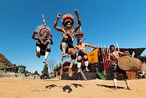
- Hornbill Festival
The Hornbill Festival is the biggest annual festival in North East India. The festival is held every year from 1 to 10 December with the purpose to promote the richness of the Naga heritage and traditions.
Media[]
Kohima is home to several television networks— Nagaland Cornerstone TV, etc. The city is also home to local newspapers such as Capi, Ralha, etc. State-owned All India Radio has a local station in Kohima, which transmits various programs of mass interest.
Transportation[]
Airports[]
Kohima is served by the Dimapur Airport located in Dimapur, 74 kilometres (46 miles) from the city centre of Kohima. The currently under construction Kohima Chiethu Airport once completed will serve as the main airport for the Greater Kohima Metropolitan Area.
Roadways[]
Kohima is connected by road with NH 2 and NH 29 which pass through the city.
Highways passing through Kohima[]
 Asian Highway 1 : Tokyo – Kohima – Istanbul
 Asian Highway 2 : Denpasar – Kohima - Khosravi
 NH 2 : Dibrugarh (Assam) – Kohima – Tuipang (Mizoram)
 NH 29 : Dabaka(Assam) – Kohima – Jessami (Manipur)
Rail[]
Kohima is not connected with the rail network. The nearest railway station is at Dimapur. An extension of the railway line from Dimapur to Kohima was proposed and surveyed in 2009.[23] Due to a dispute over land acquisition the track was resurveyed and an alternative alignment was proposed in 2013 and is expected to be completed by 2020.[24] Once completed the Kohima Zubza Railway Station will serve as the main railway station of Kohima.
Cycling[]
Regardless of its hilly terrain, cycling has become an increasingly popular way to get in and around Kohima. A bicycle-sharing system was launched in September 2020.[25][26]
Education[]
Kohima is home to some of the most prestigious educational institutions in Nagaland.
Schools[]
- Ministers' Hill Baptist Higher Secondary School
- Little Flower Higher Secondary School
- Mezhür Higher Secondary School
Universities and Colleges[]
- Kohima Science College, Jotsoma
- Model Christian College
- Alder College
- Baptist College
- Kohima College
- Mount Olive College
- Oriental College
- Kros College
- Modern College
- Kohima Law College
Sports[]
Indira Gandhi Stadium, inaugurated in 2003 is the multipurpose stadium of the city. It includes a running track and a football field.
Football[]
Kohima is home to Kohima Komets a football club that plays in the top division Nagaland Premier League.
Wrestling[]
The Naga wrestling enjoys widespread popularity in Kohima with people from all over Nagaland coming to witness the Naga Wrestling Championship held every two years at the located in the heart of Kohima. The first Naga Wrestling Tournament was held in Kohima in 1971.[27]
Gallery[]
Kohima State Museum

Welcome to Kohima Village
War Cemetery with Kohima City in background
Hornbill Festival

Kohima City


See also[]
- Tourism in North East India
References[]
- ^ Jump up to: a b c "Kohima City Population Census 2011 - Nagaland". 2011 Census of India. 2015.
- ^ Dougherty 2008, p. 159.
- ^ Ritter 2017, p. 123
- ^ "Britain's Greatest Battles". National Army Museum. Retrieved 15 December 2015.
- ^ "Maps, Weather, and Airports for Kohima, India". Retrieved 10 June 2015.
- ^ "Kohima Home NIC". Retrieved 10 June 2015.
- ^ "History". District Kohima. Retrieved 8 October 2019.
- ^ Col Ved Prakash, Encyclopaedia of North-East India, Volume 5, Atlantic Publishers & Dist, India, 2007, p. 2158
- ^ Anbarasan Ethirajan, Kohima: Britain's 'forgotten' battle that changed the course of WWII, bbc.com, India, February 13, 2021
- ^ Bert Sim, Mosstodloch, Aberdeenshire, Scotland: Pipe Major of the Gordon Highlanders at Kohima: his home is named "Kohima." -- RJWilliams, Slingerlands, NY/USA
- ^ "Epitaph". Archived from the original on 10 May 2015. Retrieved 10 June 2015.
- ^ District Kohima, Demography, kohima.nic.in, India, retrieved February 12, 2021
- ^ "Rememembering Kekuojalie Sachü & Vikhozo Yhoshü". Morung Express. Retrieved 5 July 2020.
- ^ "Kohima, India Köppen Climate Classification (Weatherbase)". Weatherbase. Retrieved 15 February 2019.
- ^ "Station: Kohima Climatological Table 1961–1990" (PDF). Climatological Normals 1961–1990. India Meteorological Department. July 2010. pp. 447–448. Archived (PDF) from the original on 16 February 2020. Retrieved 16 February 2020.
- ^ "Extremes of Temperature & Rainfall for Indian Stations (Up to 2012)" (PDF). India Meteorological Department. December 2016. p. M158. Archived from the original (PDF) on 5 February 2020. Retrieved 16 February 2020.
- ^ "Nagaland Chief Minister commissions Kohima water supply project". Eastern Mirror. 27 March 2021. Retrieved 30 July 2021.
- ^ "Kohima Municipal Council, Location of Kohima Municipal Council". kohimaonline.in. India Online.
- ^ Jump up to: a b c "Administration of Kohima, Kohima District Administration". kohimaonline.in. India Online.
- ^ Jump up to: a b c d "Kohima CDP Revised" (PDF). Government of Nagaland. July 2006. Archived from the original (PDF) on 7 January 2012. Retrieved 11 October 2017.
- ^ "Kohima Municipal Council". kmc.nagaland.gov.in. 31 March 2017.
- ^ Jump up to: a b "Kohima City religion". Census India 2011. Retrieved 22 July 2021.
- ^ Sechü, Neidilhoutuo (26 July 2013). "Slow Train Ride to Zubza". Eastern Mirror. Archived from the original on 4 December 2014. Retrieved 23 May 2018.
- ^ "The Sentinel". Archived from the original on 3 March 2016. Retrieved 10 June 2015.
- ^ "Nagaland: A step towards making Kohima smart city a hub for cycling". East Mojo. 25 September 2020. Retrieved 30 July 2021.
- ^ "Nagaland capital Kohima among India's Top 11 Cycling Pioneers". The Morung Express. 28 July 2021. Retrieved 30 July 2021.
- ^ "Naga Wrestling: The highest grossing sport in Nagaland". The Morung Express. 13 February 2020. Retrieved 30 July 2021.
External links[]
| Wikimedia Commons has media related to Kohima. |
 Kohima travel guide from Wikivoyage
- Official website
| show Authority control |
|---|
- Kohima
- Cities and towns in Kohima district
- Hill stations in Nagaland
- Tourism in Northeast India