Kunčice pod Ondřejníkem
Kunčice pod Ondřejníkem | |
|---|---|
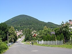 Kunčice pod Ondřejníkem under the Skalka hill | |
 Flag  Coat of arms | |
 Kunčice pod Ondřejníkem Location in the Czech Republic | |
| Coordinates: 49°33′2″N 18°15′40″E / 49.55056°N 18.26111°ECoordinates: 49°33′2″N 18°15′40″E / 49.55056°N 18.26111°E | |
| Country | |
| Region | Moravian-Silesian |
| District | Frýdek-Místek |
| First mentioned | 14th century |
| Area | |
| • Total | 20.19 km2 (7.80 sq mi) |
| Elevation | 395 m (1,296 ft) |
| Population (2020-01-01[1]) | |
| • Total | 2,373 |
| • Density | 120/km2 (300/sq mi) |
| Time zone | UTC+1 (CET) |
| • Summer (DST) | UTC+2 (CEST) |
| Postal code | 739 13 |
| Website | www |

Kunčice pod Ondřejníkem is a municipality and village in Frýdek-Místek District in the Moravian-Silesian Region of the Czech Republic. It has about 2,400 inhabitants. It lies in the Moravian-Silesian Beskids and is a popular spot for tourists.
Sights[]
There is an 18th-century wooden church in the municipality. It was relocated here from the Subcarpathian Rus in 1931.
Gallery[]

Church of Saints Procopius and Barbara

Church of Saint Mary Magdalene

Train station


References[]
- ^ "Population of Municipalities – 1 January 2020". Czech Statistical Office. 2020-04-30.
External links[]
| Wikimedia Commons has media related to Kunčice pod Ondřejníkem. |
- (in Czech) Official website
| Authority control: National libraries |
|---|
This Moravian-Silesian Region location article is a stub. You can help Wikipedia by . |
Categories:
- Populated places in Frýdek-Místek District
- Villages in Frýdek-Místek District
- Moravian-Silesian Region geography stubs