Krásná (Frýdek-Místek District)
Krásná | |
|---|---|
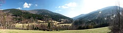 View towards the village | |
 Flag  Coat of arms | |
 Krásná Location in the Czech Republic | |
| Coordinates: 49°34′52″N 18°28′37″E / 49.58111°N 18.47694°ECoordinates: 49°34′52″N 18°28′37″E / 49.58111°N 18.47694°E | |
| Country | |
| Region | Moravian-Silesian |
| District | Frýdek-Místek |
| First mentioned | 1636 |
| Government | |
| • Mayor | Antonín Tulach |
| Area | |
| • Total | 44.08 km2 (17.02 sq mi) |
| Elevation | 520 m (1,710 ft) |
| Population (2020-01-01[1]) | |
| • Total | 682 |
| • Density | 15/km2 (40/sq mi) |
| Time zone | UTC+1 (CET) |
| • Summer (DST) | UTC+2 (CEST) |
| Postal code | 739 04 |
| Website | www |

Krásná (German: Krasna, Polish: Krasna) is a municipality and village in Frýdek-Místek District in the Moravian-Silesian Region of the Czech Republic. It has a about 700 inhabitants. Krásná lies in the Moravian-Silesian Beskids in the elevation of 520 m, in the historical region of Cieszyn Silesia.
History[]
The village was first mentioned in 1639 as Krasna.[2] It was then a part of the Friedek state country that was split from the Duchy of Teschen in 1573, which was a part of the Kingdom of Bohemia, since 1526 a part of the Habsburg Monarchy. After World War I and fall of Austria-Hungary it became a part of Czechoslovakia. In March 1939 it became a part of Protectorate of Bohemia and Moravia. After World War II it was restored to Czechoslovakia.
Twin towns – sister cities[]
Krásná is twinned with:
References[]
- ^ "Population of Municipalities – 1 January 2020". Czech Statistical Office. 2020-04-30.
- ^ "Historie obce Krásná" (in Czech). Obec Krásná. Retrieved 2021-04-19.
- ^ "Cezhraničná spolupráca". bziny.eu (in Slovak). Obec Bziny. Retrieved 2021-04-19.
- ^ "Gminy partnerskie". wilkowice.pl (in Polish). Gmina Wilkowice. Retrieved 2021-04-19.
External links[]
| Wikimedia Commons has media related to Krásná (Frýdek-Místek District). |
- (in Czech) Official website


| show Authority control |
|---|
This Moravian-Silesian Region location article is a stub. You can help Wikipedia by . |
- Populated places in Frýdek-Místek District
- Villages in Frýdek-Místek District
- Cieszyn Silesia
- Moravian-Silesian Region geography stubs