Lagos de Moreno
Lagos de Moreno | |
|---|---|
Municipality and City | |
      | |
 Coat of arms | |
| Nickname(s): Athens of Mexico (Atenas de México) | |
| Motto(s): Adversus populos Xiconaqui et Custique fortitudo | |
 Location of the municipality in Jalisco | |
 Lagos de Moreno Location in Mexico | |
| Coordinates: 21°21′N 101°55′W / 21.350°N 101.917°W | |
| Country | |
| State | |
| Founded | March 31, 1563 |
| Founded as | Villa de Santa María de los Lagos |
| Founded by | Hernando Martel and Pedro de Anda |
| Named for | Pedro Moreno and the historical lakes in the region |
| Area | |
| • Total | 2,648.22 km2 (1,022.48 sq mi) |
| Elevation | 1,942 m (6,371 ft) |
| Population (2010) | |
| • Total | 153,817 |
| • Density | 58.63/km2 (151.9/sq mi) |
| Demonym(s) | Laguense |
| Time zone | UTC-6 (Central Standard Time) |
| • Summer (DST) | UTC-5 (Central Daylight Time) |
| Area code(s) | 474 |

Lagos de Moreno (Spanish: [ˈlaɣos ðe moˈɾeno] (![]() listen)) is a city and municipality in the State of Jalisco, Mexico. Lagos is located in the region of Los Altos de Jalisco, within the macroregion of the Bajío, one of the most highly developed areas in Latin America.[1] Lagos de Moreno is occasionally known as the "Athens of Jalisco", owing to the numerous writers and poets who were born there.[2][3]
listen)) is a city and municipality in the State of Jalisco, Mexico. Lagos is located in the region of Los Altos de Jalisco, within the macroregion of the Bajío, one of the most highly developed areas in Latin America.[1] Lagos de Moreno is occasionally known as the "Athens of Jalisco", owing to the numerous writers and poets who were born there.[2][3]
Lagos de Moreno was founded as Villa Santa Maria de los Lagos on March 31, 1563, by Don Hernando Martel, an Andalusian conquistador. The town was the economic and cultural center of a region that eventually attracted many ranchers. By 1600 there were over 20,000 cattle in the region. Santa Maria continued growing both physically and culturally, and by the 1800s, the town was elevated to a city and renamed to Lagos de Moreno in honor of Pedro Moreno. Lagos de Moreno was the site of the signing of several important political documents, the two identically named but unrelated Convenios de Lagos. The arts flourished in the city during the latter half of the 19th century, but this literary boom decreased somewhat after the Mexican Revolution, especially during the 1940s. Recently, Lagos de Moreno has become an important cultural and tourist destination thanks to its rich history and architecture, some of which still stands from the 17th century.
As of the 2010 census, the city had a population of 153,818 inhabitants, making it the 6th largest city in the state of Jalisco.[4] The estimate for the population in 2015 is 164,981 people.[5] The city serves as the municipal seat of the municipality, which has an area of 2,648.22 km2 (1,022.48 sq mi) and a population of 153,817 inhabitants, and includes many other outlying small communities, the largest of which are Paso de Cuarenta (San Miguel de Cuarenta) and Los Azulitos.[4]
Etymology[]
The conquistador Hernando Martel gave Lagos de Moreno its original name, Villa de Santa Maria de los Lagos (Town of Saint Mary of the Lakes). The town's name was derived from Saint Mary, the townspeople's chosen patron saint, and the numerous lakes that used to be scattered across the valley. The town was renamed on April 9, 1829, as Lagos de Moreno in honor of Mexican independence hero Pedro Moreno, who was born in the city.
History[]
Pre-hispanic era[]
The origins of Lagos de Moreno date to its founding as Pechichitlán or Teziziatlan by Ahnuvic VII in about 1028 BCE. Then the city served as a capital for the Chichimecatlalli fiefdom.[4] In the 12th century, semi-nomadic Guachichiles occupied the valley and dominated an extensive area stretching from present-day San Juan de los Lagos to southern Coahuila. Before the colonization of Mexico began, indigenous culture thrived in this area, with notable pre-Hispanic architecture being established at Rincón de Mesa, Sauceda, and El Maguey.[6]
Colonial era[]
After the fall of the Aztec Empire, explorers set out to explore the western frontier in the Bajio Region. The Spanish expansion in Nueva Galicia was slowed down by several tribes in the vicinity, such as the semi-nomadic Chichimecas and the Guachichiles. To the east of Pechititan, the Guamares inhabited the Guanajuato area, and to the west, the Zacatecos lived. The Zacateco caudillos (chiefs), Xiconaqui and Custique, along with the Chichimecas, struck down multiple Spanish invasions from 1550 to 1590 in the well-known Chichimeca War.
However, encomenderos gradually occupied the Bajio. The first Spaniard to build a hacienda in the Laguense valley was Don .[7] Even so, in 1551, a group of Chichimecas attacked his ranch (La Sauceda and San Antonio) and killed all his animals. The constant raids in the area made, for the time being, made settlement of the Lagos region impossible.[6]
Founding of Lagos[]

After decades of constant combat and raids, the first Spanish authorities of the region were appointed; the priest of Teocaltiche and the Mayor of Teocaltiche had the region stretching from Teocaltiche to the Lagos valley as their jurisdiction. Later, the Royal Audiencia of Nueva Galicia ordered the Mayor of Teocaltiche, Don Hernando Martel from Seville, to establish a town in the vicinity of Pechichitan. The new settlement was founded jointly with the first priest and vicar of the local parish, father , who also participated in the official founding of the Real Comanja mine in 1561.[6] As such, on March 31, 1563, Villa de Santa María de los Lagos was founded by Martel, Cuenca, and Captain Don Pedro de Anda, along with 72 or 73 Spanish noble families and their servants and slaves.[4][6]
Development
The residents of Santa Maria chose the Virgin Mary as the namesake of their town and Saint Sebastian as a minor patron saint. The settlement and its surroundings became quite appealing to ranchers; by 1600 around 20,000 head of cattle were active in the Lagos valley, facilitating the eventual creation of the charreria-style rodeo.[7] The increasing population of the area contributed to the naming of the first ordinary Mayor of Santa Maria de los Lagos, the miner from Guanajuato. Marfil would be succeeded by , the first and only clergyman to-date to serve as mayor of the town.
The town continued to grow steadily in the 17th century, benefiting from the general prosperity of the Golden Age of the Spanish Empire. In 1615, a new jail was inaugurated, and 1621 saw the construction of a third parish temple with a tower that would be completed by 1685. Religious buildings were created often during this period; the Convent of the Poor Capuchins of Saint Joseph was founded and the construction of the Parish Church of Our Lady of the Assumption and the Temple of Our Lady of the Rosary began during this time.[6]
Mexican War of Independence[]

Santa Maria de los Lagos, like the rest of New Spain, underwent rapid political change in the early 1800s. The lawyer Francisco Primo de Verdad y Ramos spoke to Spanish authorities, advocating for Mexican independence. He died under mysterious circumstances in the dungeon of the Mexico City Trustee building. In the initial phase of the war, Father Miguel Hidalgo y Costilla visited Santa Maria de los Lagos and provided religious services there, and recruited some families for the fight against the forces of the Spanish Viceroy.[7]
Independence to present[]
| UNESCO World Heritage Site | |
|---|---|
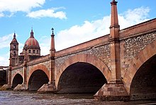 The historic Lagos Bridge with the Temple of Our Lady of the Light in the distance | |
| Location | Lagos de Moreno, Jalisco, Mexico |
| Criteria | ii, iv |
| Reference | 1351-017 |
| Inscription | 2010 (34th Session) |
In 1823, the Convenio de Lagos (Agreement of Lagos) was signed in Santa Maria by Nicolas Bravo, Pedro Celestino Negrete, and Luis Quintanar, establishing the Free and Sovereign State of Jalisco. On March 27, 1824, Santa Maria was given the title of city.[6] On April 9, 1829, the city was renamed as Lagos de Moreno in memory of insurgent General Pedro Moreno (1775-1817), a founding father of Mexico who led forces against Spanish authorities in the Mexican War of Independence.[4][6]
In 1855, a second and similarly titled Convenio de Lagos (Agreement of Lagos) was signed in Lagos de Moreno, in which Manuel Doblado and recognized the Plan of Ayutla, thus joining the movement to topple conservative President Antonio López de Santa Ana. During the Reform War, Lagos de Moreno changed hands between liberal and conservative forces multiple times until an eventual liberal victory in 1861.[6]
During the Mexican Revolution in the 1910s, residents of Lagos de Moreno like Mariano Azuela and joined the fighting.[6][7] In the subsequent Cristero War, the nearby Mesa Redonda was the site of a battle between federal troops and rebel forces.[8]
In 1963, Lagos de Moreno celebrated the 400th anniversary of its founding. In recent times, the city has received several important titles. It has been named an Area of Historical Monuments by the National Institute of Anthropology and History (INAH) in 1989, a World Heritage Site on the Camino Real "Tierra Adentro" by UNESCO on August 1, 2010, and "Pueblo Mágico" by SECTUR on November 16, 2012.[6][7]
Geography[]
Climate[]
Lagos de Moreno has a subtropical highland climate (Köppen climate classification Cwb) with mild temperatures year round.[9] Temperatures are generally similar for any given month, but daily high and low fluctuations can be very sharp in the winter due in part to the city's altitude and its uneven surroundings. Winters are mild with an average maximum temperature of 23 °C (73.4 °F) in January although nighttime temperatures are often cold, with an average minimum temperature of 3 °C (37.4 °F).[10] Many days are sunny, averaging around 15-19 clear days per month and precipitation is low.[11] Nighttime temperatures regularly fall below 0 °C (32.0 °F) but extended periods of frost are rare.[11]
The Bajio's two main seasons are the wet season and the dry season. The wet season, which runs from June to October sees an increase in precipitation and humidity with July and August being the wettest months. The record high was 42.0 °C (107.6 °F) on March 26, 1942[12] and the record low was −9.0 °C (15.8 °F) on January 24, 1955.[10] The table below shows detailed statistics on the climate of Lagos de Moreno.
| hideClimate data for Lagos de Moreno (1951–2010) | |||||||||||||
|---|---|---|---|---|---|---|---|---|---|---|---|---|---|
| Month | Jan | Feb | Mar | Apr | May | Jun | Jul | Aug | Sep | Oct | Nov | Dec | Year |
| Record high °C (°F) | 35.5 (95.9) |
39.0 (102.2) |
42.0 (107.6) |
37.5 (99.5) |
41.5 (106.7) |
40.0 (104.0) |
36.0 (96.8) |
36.0 (96.8) |
34.0 (93.2) |
39.5 (103.1) |
34.0 (93.2) |
33.0 (91.4) |
42.0 (107.6) |
| Average high °C (°F) | 22.8 (73.0) |
24.7 (76.5) |
27.1 (80.8) |
29.3 (84.7) |
30.8 (87.4) |
28.8 (83.8) |
26.4 (79.5) |
26.4 (79.5) |
26.2 (79.2) |
26.2 (79.2) |
25.2 (77.4) |
23.1 (73.6) |
26.4 (79.5) |
| Daily mean °C (°F) | 12.8 (55.0) |
14.2 (57.6) |
16.4 (61.5) |
18.8 (65.8) |
20.9 (69.6) |
21.2 (70.2) |
19.8 (67.6) |
19.6 (67.3) |
19.2 (66.6) |
17.6 (63.7) |
15.3 (59.5) |
13.4 (56.1) |
17.4 (63.3) |
| Average low °C (°F) | 2.8 (37.0) |
3.6 (38.5) |
5.6 (42.1) |
8.3 (46.9) |
10.9 (51.6) |
13.5 (56.3) |
13.2 (55.8) |
12.8 (55.0) |
12.3 (54.1) |
9.1 (48.4) |
5.4 (41.7) |
3.6 (38.5) |
8.4 (47.1) |
| Record low °C (°F) | −9.0 (15.8) |
−7.5 (18.5) |
−4.5 (23.9) |
−1.0 (30.2) |
1.0 (33.8) |
3.0 (37.4) |
4.0 (39.2) |
5.0 (41.0) |
1.0 (33.8) |
−3.0 (26.6) |
−6.0 (21.2) |
−5.2 (22.6) |
−9.0 (15.8) |
| Average precipitation mm (inches) | 25.4 (1.00) |
24.9 (0.98) |
16.5 (0.65) |
29.4 (1.16) |
47.8 (1.88) |
102.7 (4.04) |
158.8 (6.25) |
138.5 (5.45) |
122.6 (4.83) |
59.9 (2.36) |
21.7 (0.85) |
11.0 (0.43) |
759.2 (29.89) |
| Average precipitation days (≥ 0.1 mm) | 2.5 | 2.3 | 1.5 | 2.5 | 5.4 | 10.9 | 15.3 | 14.5 | 12.1 | 6.0 | 2.0 | 1.6 | 76.6 |
| Average relative humidity (%) | 59 | 53 | 48 | 48 | 51 | 64 | 70 | 73 | 72 | 68 | 64 | 64 | 61 |
| Mean monthly sunshine hours | 231.3 | 240.7 | 273.5 | 282.5 | 289.9 | 230.4 | 224.8 | 223.3 | 203.2 | 241.4 | 244.8 | 214.5 | 2,900.3 |
| Source 1: Servicio Meteorológico Nacional[10][12] | |||||||||||||
| Source 2: Colegio de Postgraduados(sun and humidity)[11] | |||||||||||||
Topography[]

Lagos de Moreno is situated 1,942 meters (6,371 feet) above mean sea level.[13] Lagos is located in the region of Los Altos de Jalisco, within the macroregion of the Bajío, one of the most highly developed areas in Latin America.[1] The city's vicinity is quite mountainous and hilly, with the nearby Mesa Redonda being a particularly notable formation.[14]
Flora and fauna[]
The nearby Mesa Redonda is home to many unique species of flora. There, two species of cactus endemic only to Jalisco flourish, with one of these species only being endemic to the Mesa Redonda, particularly its very steep slopes, protecting it from predators.
Many animals call the Lagos valley home, with fauna including hares, rabbits, deers, and boars. Residents of nearby ranches have commented on the presence of coyotes and snakes in rural areas. Areas like the Mesa Redonda have been utilized by locals to gather vegetables straight from nature, particularly prickly pear cacti.[14]
Demographics[]
As of the 2010 census, the city had a population of 153,817 inhabitants, making it the 6th largest city in the state of Jalisco.[4] The estimate for the population in 2015 is 164,981 people.[5] Lagos de Moreno has a slightly higher female population compared to males with 79,345 females compared to 74,472 males, meaning that the female population is 6.14% higher than the male population.[15]
Notable natives and residents[]
Politics[]
- Pedro de Anda, Spanish conquistador and founder of Lagos de Moreno
- Luis Alfonso de Alba Góngora, Mexican under-secretary for Latin America in the Secretary of Foreign Relations, former Mexican Representative to the United Nations
- Ramón Muñoz Gutiérrez, Senator of Jalisco in the Mexican Senate of the Republic
- Emilio González Márquez, former Governor of Jalisco
- Pedro Moreno, general and father of the Mexican War of Independence
- Francisco Primo de Verdad y Ramos, 18th-century lawyer and politician of colonial New Spain
Culture[]
- Lola Álvarez Bravo, famed photographer, prominent figure of the post-Mexican Revolution artistic renaissance
- Juan Pablo Villalobos, author and entrepreneur
- José Rosas Moreno, 19th-century writer, fableist, and poet
- Mariano Azuela González, 19th/20th-century literary critic, novelist, and essayist
Athletics[]
- Luis Fernando Macías, professional cyclist, silver medalist at the 2009 Pan-American Road and Track Championship
- Armando Reynoso Gutiérrez, baseball player for the Mexico national team, Mexican Baseball Hall of Fame member
- Isaác Brizuela Muñoz, Mexican-American footballer for C.D. Guadalajara
- Carmelo Reyes González, former professional wrestler
Gallery[]

Maria Soine de Helguerra Regional Public Library

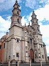
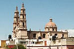
Our Lady of the Ascension of the Virgin Mary Parochial Church

N. Sra. de la Luz Church at sunset

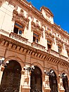
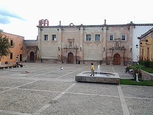
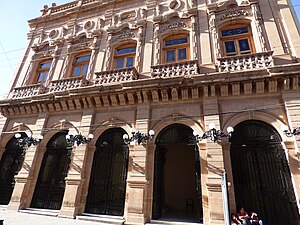
The Municipal Palace of Lagos de Moreno
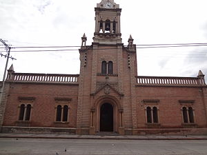
San José de Gracia de Pobres Capuchinas Convent

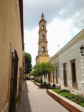
José Rosas Moreno Theatre

The Temple of Calvario
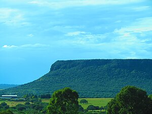
La Mesa Redonda
La Merced Temple

Comanja Temple

Miguel Leandro Guerra School of Arts and Trades

N. Sra. de la Luz Church
San Felipe de Jesús Temple

Asunción de María Park

Panteon de la Soledad

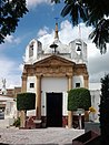
San Miguel Church
Teatro José Rosas Moreno

N. Sra. del Refugio Church


Transportation[]
The city used to be served by the Francisco Primo de Verdad National Airport (IATA: LOM). The nearest airport, Del Bajio International Airport (IATA: BJX) is located near Silao, Guanajuato, an hour's drive away.[16]
References[]
- ^ Jump up to: a b Cruz, Osiel (16 August 2013). "Bajío, el nuevo milagro mexicano".
- ^ "Lagos de Moreno 2020, #52 places to visit in jalisco, top things to do, reviews, best tourist places to visit for 4 - 7 Days, photo gallery | HelloTravel Mexico". www.hellotravel.com. Retrieved 2020-04-03.[permanent dead link]
- ^ Luciérnaga, La (2011-06-25). "La Atenas de Jalisco: Lagos de Moreno: "La Atenas de Jalisco"". La Atenas de Jalisco. Retrieved 2020-04-03.
- ^ Jump up to: a b c d e f "Lagos de Moreno". mexicanroutes.com. Retrieved 2020-04-03.
- ^ Jump up to: a b "Número de habitantes. Jalisco". cuentame.inegi.org.mx. Retrieved 2020-04-03.
- ^ Jump up to: a b c d e f g h i j "Fundación e historia de Lagos de Moreno". www.elclima.com.mx (in Spanish). Retrieved 2020-04-03.
- ^ Jump up to: a b c d e Cana, Marco. "Lagos de Moreno Pueblo Magico". www.pueblosmexico.com.mx. Retrieved 2020-04-03.
- ^ Contreras, Karla Zafiro Rizo (2015-12-16). "Adiós a la mesa redonda. La segunda Cristiada en Lagos de Moreno". Diversae. Revista del Seminario de Historia Mexicana (in Spanish). 1 (1).
- ^ Kottek, M.; J. Grieser; C. Beck; B. Rudolf; F. Rubel (2006). "World Map of the Köppen-Geiger climate classification updated" (PDF). Meteorol. Z. 15 (3): 259–263. doi:10.1127/0941-2948/2006/0130. Retrieved December 22, 2012.
- ^ Jump up to: a b c "Lagos de Moreno (DGE) Normales climatológicas 1951-2010" (in Spanish). Servicio Meteorológico Nacional. Archived from the original on March 3, 2016. Retrieved January 10, 2013.
- ^ Jump up to: a b c "Normales climatológicas para Lagos de Moreno, Jalisco" (in Spanish). Colegio de Postgraduados. Archived from the original on February 21, 2013. Retrieved January 10, 2013.
- ^ Jump up to: a b "Extreme Temperatures and Precipitation for Lagos de Moreno 1942-2010" (in Spanish). Servicio Meteorológico National. Archived from the original on March 3, 2016. Retrieved January 21, 2013.
- ^ "Lagos de Moreno, Jalisco Mines". The Diggings™. Retrieved 2020-04-04.
- ^ Jump up to: a b Moreno, Radio UdeG Lagos de (2018-07-31). "Mesa redonda, el emblema natural de Lagos de Moreno". UDG TV (in Spanish). Retrieved 2020-04-04.
- ^ Geografía (INEGI), Instituto Nacional de Estadística y (2016-01-01). "Buscador INEGI". www.inegi.org.mx (in Spanish). Retrieved 2020-04-04.
- ^ "Del Bajío International - Mexico". World Airport Codes. Retrieved 2020-04-04.
Sources[]
- Link to tables of population data from Census of 2005 INEGI: Instituto Nacional de Estadística, Geografía e Informática
- Jalisco Enciclopedia de los Municipios de México
External links[]
| Wikimedia Commons has media related to Lagos de Moreno. |
- Fotografias de Lagos de Moreno www.alxkueyar.com
- Laguenses en el exterior www.laguenses.com
- Ayuntamiento de Lagos de Moreno Official website
Coordinates: 21°21′N 101°55′W / 21.350°N 101.917°W
| show |
|---|

| show Authority control |
|---|
- Municipalities of Jalisco
- Pueblos Mágicos