Teocaltiche
Teocaltiche | |
|---|---|
Municipality and Town | |
 | |
 Coat of arms | |
| Nickname(s): Teocal | |
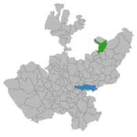 Location of the municipality in Jalisco | |
 Teocaltiche Location in Mexico | |
| Coordinates: 21°15′N 102°23′W / 21.250°N 102.383°W | |
| Country | |
| State | |
| Municipality | Teocaltiche |
| Settled | 1187 |
| Founded | 1530 |
| Incorporated (Municipality) | November 22, 1869 |
| Government | |
| • Type | Ayuntamiento |
| • Municipal Pres. | |
| • Municipal Trustee | |
| • Controller | |
| • Treasurer | |
| • Municipal Clerk | |
| Area | |
| • Total | 895.6 km2 (345.8 sq mi) |
| Population (2005) | |
| • Total | 36,976 |
| • Demonym | Chapulin or Chapulines |
| Time zone | UTC-6 (Central Standard Time) |
| • Summer (DST) | UTC-5 (Central Daylight Time) |

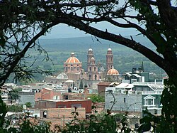
Teocaltiche (Nahuatl languages: Teocaltillitzin "place near the temple") is a town and municipality in the central-western Mexican state of Jalisco. It is located in the northeastern highlands region of Jalisco, commonly referred to in Spanish as "Los Altos de Jalisco". The grasshopper or "chapulin" is a popular icon for the town.
The town is also known for its tourism, for example, the "Hospital de los Indios" (or alternatively "la Capilla") is a chapel in the city centre and the oldest standing building of Teocaltiche, built approximately in the year 1546 by the Spanish conquistadors. Teocaltiche is one of the oldest settlements with Hispanic influence from the time of the Spanish conquest. The territory was conquered by Cristóbal de Oñate and Manuel de Ibarra in March 1530 on the order of Nuño de Guzmán.

Industry[]
Main manufacture of the region is agricultural products and livestock. The farmers raise horses, cows, sheep, pigs, poultry, and goats. Agriculture includes the production of onions, corn, oats, beans, and alfalfa. There are also many artisans that sell hand-crafted goods.
Notable people from Teocaltiche[]
- Ángel Alonzo, Mexican footballer (Club Necaxa, Liga MX)
- José Guadalupe Cruz, Mexican comics writer and screenwriter
- Mario Díaz Pérez, Mexican football manager and former football player
- Victoriano Salado Álvarez, Mexican writer and politician
- Roberto Sánchez, Mexican hurdler
- Carlos Manuel Villalobos Organista, Mexican politician
References[]
External links[]
Coordinates: 21°15′00″N 102°22′59″W / 21.250°N 102.383°W

| show Authority control |
|---|
- Municipalities of Jalisco