Tizapan El Alto
Tizapán El Alto | |
|---|---|
Municipality and city | |
 Coat of arms | |
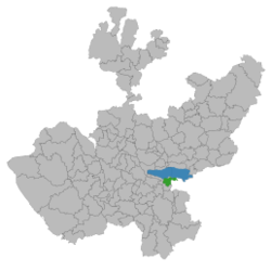
 Location of the municipality in Jalisco | |
 Tizapán El Alto Location in Mexico | |
| Coordinates: 20°09′31.2″N 103°02′35.7″W / 20.158667°N 103.043250°WCoordinates: 20°09′31.2″N 103°02′35.7″W / 20.158667°N 103.043250°W | |
| Country | |
| State | Jalisco |
| Date of Foundation | December 29, 1529 |
| Government | |
| • Type | Municipal Government |
| • Presidente municipal de Tizapán el Alto | José Santiago Coronado Valencia |
| Area | |
| • Total | 273.32 km2 (105.53 sq mi) |
| Population (2020) | |
| • Total | 22,758 |
| Time zone | UTC-6 (Central Standard Time) |
| • Summer (DST) | UTC-5 (Central Daylight Time) |
| C.P | 49400 |
| Area code(s) | 376 |
| Website | www |
Tizapán El Alto is a town and municipality, in Jalisco in central-western Mexico. The municipality covers an area of 273.32 km².
As of 2020, the municipality had a total population of 22,758.[1]
History: [2]According to some scholars of anthropology, due to the pre-Cortesian vestiges that exist, the Toltecs inhabited this region without being able to specify exactly the date on which the settlements that were formed both in what is today the municipal seat and in its vicinity took place. Some affirm that back in the 7th century of our era, various tribes began to settle on the banks of Lake Chapala and also of the river today called La Pasión. Oral tradition indicates that, after the conquest, a mixed congregation was formed, that is, of Indian and Spanish origin and indicates the date of December 29, 1529, since Don Alonso de Ávalos, cousin, had already passed through these lands. of Hernán Cortés and closely linked in interests to the conqueror. The same tradition indicates as petitioners of the legal estate the Spaniards Juan de la Salud, Lorenzo Manuel Taracho Tadeo, Bernardino de los Reyes, Pedro Joseph, Concepción de los Ángeles, Silvestre de los Santos, Ignacio Cupertino and Cristóbal Nolasco, as well as the indigenous Roque Jorge, Franco Javier, Diego Salvador, Gregorio Magdaleno and Juan Evangelista. All of them with their respective families that multiplied until they formed what was then called the Estancia de Tizapán and several decades later San Francisco Tizapán. On March 27, 1824, it was assigned to the canton of Sayula, and to the department of Zacoalco. In 1825 he continues to belong politically to Sayula and the 3rd. Department of Zacoalco, having under its jurisdiction the Haciendas of Santa Ana and San Francisco Javier, adjacent to its head. In 1837, in the jurisdiction of Sayula belonging to Zapotlán el Grande. In 1843 it belongs to the 4th District of Sayula and to the first party of that city. In 1878, always belonging to Sayula, it passed to the 2nd Department of Zacoalco. In 1886, by decree of General Ramón Corona, at the same time Governor of the State, Tuxcueca was segregated from Tizapán, to become a municipality. In 1886, La Manzanilla was integrated as a Police Station and in 1890, Decree 426, created the Civil Registry Office, being included, within the designated police station, the ranches of La Tuna Manza, Las Cuevas, Agua Escondida, La Cañada , La Soledad, La Peña and Palos Verdes. In 1896, it became part of the 7th Canton of Chapala by decree 747 of December 30 of that same year. In 1906, by decree of Governor Miguel Ahumada, the La Manzanilla Police Station became a municipality. In 1924, the Estancia de Columba was erected as a police station and in 1947 that of El Volantín. In 1998, the Municipality had the municipal seat, 2 delegations and 8 municipal agencies
Tizapan has 8 municipal agencies and 2 deligations, including:
The 8 Municipal Agents: Mismaloya, El Refugio, La Rosa Amarilla, Colonia Madero, Churinztio, El Zapote, Los Sauces, and La Cañada
The 2 Deligations: Villa Emilliano Zapata and El Volantín
References[]
- ^ "Tizapan El Alto". Enciclopedia de los Municipios de México. Instituto Nacional para el Federalismo y el Desarrollo Municipal. Retrieved April 16, 2009.
- ^ "Tizapán el Alto | Gobierno del Estado de Jalisco". www.jalisco.gob.mx. Retrieved 2021-12-01.
- Jalisco geography stubs
- Municipalities of Jalisco

