Lake Bonneville
| Lake Bonneville | |
|---|---|
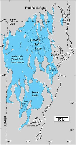 Map of Lake Bonneville, showing the outline of the Bonneville shoreline, the highest level of the lake. [figure prepared by Oviatt, C.G., 2019; a similar map was published in reference 3]. | |
 Lake Bonneville | |
| Location | Utah, Idaho, Nevada |
| Coordinates | 41°N 113°W / 41°N 113°WCoordinates: 41°N 113°W / 41°N 113°W |
| Type | pluvial lake (a paleolake created by a change in water balance in the basin) |
| Etymology | Benjamin Bonneville |
| Surface area | ~20,000 sq mi (51,000 km2) (at max. lake level) |
| Max. depth | over 980 ft (300 m) |

Lake Bonneville was the largest Late Pleistocene paleolake in the Great Basin of western North America. The Western Interior Seaway preceded Lake Bonneville.[1][2] Lake Bonneville was a pluvial lake that formed in response to an increase in precipitation and a decrease in evaporation as a result of cooler temperatures. Lake Bonneville covered much of what is now western Utah and at its highest level extended into present-day Idaho and Nevada. Many other hydrographically closed basins in the Great Basin contained expanded lakes during the Late Pleistocene, including Lake Lahontan in northwestern Nevada.
Geologic description[]
Shorelines of Lake Bonneville are visible above Salt Lake City along the western front of the Wasatch Mountains and on other mountains throughout the Bonneville basin.[3] These shorelines appear as shelves or benches that protrude from the mountainside above the valley floor, are visible on the ground from long distances and on satellite images, and have both depositional and erosional segments along their lengths.[4] Three shorelines of Lake Bonneville that can be traced throughout the basin, have been given names: Stansbury, Bonneville, and Provo.[3] The Stansbury and Bonneville shorelines formed during the transgressive phase of Lake Bonneville; the Provo shoreline formed during the overflowing phase.[5] Numerous other unnamed shorelines, which cannot be mapped everywhere in the basin, some of which formed during the transgressive phase and some during the regressive phase, are also present on piedmont slopes and alluvial fans. At its maximum, when Lake Bonneville was more than 980 ft (300 m) deep and almost 20,000 sq mi (51,000 km2) in surface area,[6] it covered almost as much area as modern Lake Michigan although its shoreline was more complex with many islands and peninsulas. Great Salt Lake, Utah Lake, and Sevier Lake are the largest post-Bonneville lakes in the Bonneville basin.
Causes of lake expansion and contraction[]
Lake Bonneville was not a "proglacial” lake, although it did form between about 30,000 and 13,000 years ago when glaciers at many places on Earth were expanded relative to today during the last major glaciation.[7] For most of its existence (that is, during the transgressive plus regressive phases) Lake Bonneville had no river outlet and occupied a hydrographically closed basin.[3][5] Changes in lake level were the result of changes in water balance caused by climate change (a simplified version of the water-balance equation is inputs equal outputs plus-or-minus storage changes).[3][5][8] Storage changes are equal to volume changes, and changes in volume are correlated with changes in lake level. When inputs (i.e., precipitation; runoff in rivers) were greater than outputs (i.e., evaporation from the lake surface; evapotranspiration in the basin), lake level rose, and when outputs were greater than inputs, lake level fell.[9] Changes in global atmospheric circulation led to changes in the water budget of Lake Bonneville and other lakes in the Great Basin of western North America.[9][10][11] Mountain glaciers in the Bonneville drainage basin stored less than 5% of the water that Lake Bonneville held at its maximum,[12] so that even if all the mountain glaciers in the basin melted at once and the water flowed into the lake (this didn't happen—it took thousands of years for the mountain glaciers to melt, and Lake Bonneville was falling by that time), it would have had little effect on lake level. Lake Bonneville had no river connection with the huge North American ice sheets.[12] While Lake Bonneville existed the patterns of wave- and current-forming winds were not significantly affected by the Laurentide and Cordilleran ice sheets in northern North America.[13]
The name “Bonneville”[]
Lake Bonneville was named by the geologist G.K. Gilbert after Benjamin Louis Eulalie de Bonneville (1796–1878),[3] a French-born officer in the United States Army who was also a fur trapper and explorer in the American West. Bonneville's adventures were popularized by Washington Irving in the 1800s,[14] but Captain Bonneville probably never saw Great Salt Lake or the Great Basin.[15] G.K. Gilbert was one of the greatest geologists of the 19th Century, and his monumental work on Lake Bonneville, published in 1890,[3] set the stage for scientific research on the paleolake that continues today.[16] Although a general description and understanding of Lake Bonneville has been established by the work of many people, details of the paleolake, including its history and connections to global environmental systems, will be pursued for many years to come.


Geologic history[]
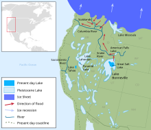
Lake Bonneville began to rise from elevations similar to those of modern Great Salt Lake about 30,000 years ago.[5] During its transgressive phase in the closed basin (an endorheic basin), lake level oscillated because of changes in climate[17] but the lake gradually rose until about 18,000 years ago when it reached its highest elevation, marked by the Bonneville shoreline. At that level the lake had risen to the lowest point on its basin rim and had begun to overflow into the Snake River drainage near Red Rock Pass in what is now southeastern Idaho.[18][19] The overflow, which would have begun as a trickle across the dam formed by the Marsh Creek alluvial fan, quickly evolved into a tremendous flood, the Bonneville flood, which charged down the Marsh Creek valley to the Portneuf River, into the Snake River and then into the Columbia River and Pacific Ocean.[3][18] Groundwater sapping on the north slope of the Marsh Creek alluvial fan, which began long before the lake had reached its highest level, added to the instability and ultimate collapse of the fan-dam.[18][19]
The Bonneville flood probably lasted less than a year, during which time almost 1,200 cu mi (5,000 km3) of water flowed out of the lake basin with a maximum discharge of about 35,000,000 cu ft/s (1,000,000 m3/s).[18] Downcutting during the flood through the Marsh Creek alluvial-fan deposits and into the underlying Neogene sand, mud, and landslide debris,[19] caused lake level to drop about 430 ft (130 m).[20] River flow from the lake across the Red Rock Pass threshold and out of the lake basin continued non-catastrophically for about 3000 years after the flood ended; the Provo shoreline formed during this overflowing phase.[3][5] The Provo shoreline is distinguished from other shorelines of Lake Bonneville by its topographic position, strong development, and thick accumulations of tufa.[3] At the end of the overflowing phase, about 15,000 years ago, climate change and a shift to a negative water balance (more water evaporated off the surface of the lake than entered by rivers or direct precipitation) caused the lake to return to its closed-basin status as it declined to lower levels during the regressive phase.[5] By 13,000 years ago the lake had fallen to an elevation similar to the average elevation of modern Great Salt Lake. During the regressive phase lake level declined approximately 660 ft (200 m) in about 2000 years because of a change to warmer and drier climate (660 ft (200 m) is roughly 2/3 of the maximum depth of Lake Bonneville). Although Lake Bonneville and the Great Salt Lake are collectively one lake system, the name “Lake Bonneville” is applied to the lake during the period from 30,000 to 13,000 years ago, and the name “Great Salt Lake” since 13,000 years ago.[21]
Lake Bonneville was anomalous in the long-term history of the basin. As the largest of four deep lakes in the basin during the past 800,000 years, Lake Bonneville plus the other three deep Pleistocene lakes, persisted for less than 10% of the time.[22][16] The conditions experienced in the basin today are typical of over 90% of the past 800,000 years: a dry desert basin with a few scattered low-elevation lakes, the largest of which (Great Salt Lake) was hypersaline. For most of the time between the end of the youngest of the deep pre-Bonneville lakes (the Little Valley lake cycle, about 150,000 years ago)[7] and the initial rise of Lake Bonneville about 30,000 years ago, the lake would have resembled modern Great Salt Lake in surface area and depth. A short episode of slightly higher lake levels during the Cutler Dam lake cycle occurred about 60,000 years ago;[23] at this time a moderate-sized lake rose above the level of Great Salt Lake, but not as high as Lake Bonneville.

In his monograph on Lake Bonneville, G.K. Gilbert called the offshore deposits of Lake Bonneville the “White Marl.”[3] Although the name “White Marl” has not been used by the geologic community in a formal sense, the informal term “white marl” (or “Bonneville marl”) is frequently employed.[24] The Bonneville marl at locations far from sources of clastic sediment (gravel, sand, and silt), such as river deltas or active wave zones, is dominated by clay-sized particles of calcium carbonate that precipitated chemically from the lake water.[24] Most of this calcium carbonate is in the form of the mineral calcite, but aragonite is common in Bonneville marl in the Sevier basin and in the lower part of the Bonneville marl stratigraphic section in the main body.[25] Aragonite is the dominant carbonate mineral in sediments of post-Bonneville Great Salt Lake.[26][27] Dropstones, probably mostly derived from shore ice, but possibly also from floating root balls, are common in the marl, and consist of granule- to boulder-sized clasts.[24]
The Bonneville flood had catastrophic effects along the Snake River in what is now Idaho, but the influence of the flood can also be detected within the lake basin where a distinctive layer of sediment was deposited. The Bonneville flood bed can be identified in many surface exposures below the Provo shoreline and in sediment cores.[24] The flood bed is characterized by an abrupt contact at its base between massive marl, which was deposited in the deepest water of Lake Bonneville, and finely laminated or ripple-laminated sandy marl, which was deposited by bottom currents during the flood.[24][25] In places the Bonneville flood bed is composed of reworked ostracode shells. The contact at the top of the flood bed is transitional to massive marl that was deposited in the lake floor during Provo time.[24] The flood bed is best developed and most obvious in straits between partially submerged mountain ranges or in places where bottom currents were strong as lake water flowed toward its outlet at Red Rock Pass. Because the Bonneville flood bed was deposited in less than a year, it is useful as a well-dated (~18,000 years ago) stratigraphic marker within the Bonneville deposits.[24]
Previous publications,[28] regarded the “Gilbert shoreline” as one of the prominent shorelines in the Bonneville basin, but this interpretation has been revised.[29] The “Gilbert shoreline” consists of a line on a map that connects lacustrine shoreline features, such as barrier beaches, but there is no evidence that all the barriers formed at the same time.[29] It is now clear that some of those barrier beaches are transgressive-phase Bonneville in age and some are regressive-phase Bonneville in age.[29] The Gilbert episode was a rise of Great Salt Lake about 49 ft (15 m) higher than modern average levels, which culminated 11,600 years ago. But a mappable shoreline of the Gilbert episode has not been recognized.[29]
Isostasy[]
The shorelines of Lake Bonneville have been warped by isostatic processes, as was recognized by Gilbert and extensively studied since Gilbert's day.[3][30] Earth's crust subsided beneath the weight of the water while the lake existed, but when the lake evaporated and the water load was considerably reduced, the crust beneath the lake basin rebounded. As a result, the elevation of the Bonneville shoreline is 243 ft (74 m) higher in the Lakeside Mountains, elevation 5,335 ft (1,626 m), west of the Great Salt Lake near the center of the Lake Bonneville water load, than at Red Rock Pass, 5,092 ft (1,552 m), where the lake was very shallow.[28] As an example of isostatic deformation of the shorelines, the elevation of the Bonneville shoreline near Salt Lake City is 5,203 ft (1,586 m), but on Antelope Island in the Great Salt Lake, the elevation of the same shoreline is 5,246 ft (1,599 m).[4][28]
Fossils, volcanic ashes, etc.[]
In addition to the abundant geological features produced by Lake Bonneville, such as shorelines and sediments, fossilized fish bones and scales reveal information about the physical and chemical characteristics of the paleolake.[31] Pollen from plants that lived in the Bonneville basin is abundant in Bonneville marl.[27] Invertebrate fossils in Lake Bonneville deposits include mollusks and ostracodes,[3][32] and bones of extinct mammals are found in Pleistocene deposits in the Bonneville basin.[33] Volcanic ashes in sediments of Lake Bonneville help with correlations and aid in deciphering lake history.[34] Lake Bonneville shorelines, and those of other paleolakes on Earth, are good analogs for shorelines on other planets, such as Mars.[35]
Climate Oscillations, the Wasatch Fault and a Bonneville Flood theory[]
Lake Bonneville rose to its high stand during the final 20,000 years of the Pleistocene epoch, corresponding with the glacial maximum of the Laurentide and Cordillera Ice Sheets. This colder and wetter period in conjunction with lake-effect snows from the expanding Lake Bonneville resulted in glaciers in the Wasatch. At its maximum the glacier in Little Cottonwood canyon extended to the mouth of the canyon and was calving ice bergs into the lake.[36]
Lake Bonneville shoreline and strata evidence suggests that the lake experienced several dramatic short-term level oscillations during its life. A long-standing and well-accepted theory attributes these level fluctuations to climate oscillations.[37]

The Wasatch Fault runs along the eastern edge of the Lake Bonneville basin and was submerged when the lake was at its high stand (see figure). The fault naturally divides into segments and since the time of Lake Bonneville these segments have appeared to have slipped (failed) independently (e.g. an earthquake in the Salt Lake valley has not tended to occur at the same time as one in Weber or in Provo).
A 2020 paper presented at the Geological Society of America Annual Meeting reported evidence of massive earthquake-induced surging in Lake Bonneville at the time of the Bonneville Flood.[38] The proposal in that presentation was that a multi-segment failure on the Wasatch Fault resulted in lake surging within the Bonneville Basin and, as that surge moved up into the Cache Valley towards Red Rock Pass and the Zenda Threshold, the topography concentrated the energy into a wall of water which overtopped and broke the natural dam resulting in the Bonneville Flood.

In 2021 additional evidence was presented in support of that theory.[39] In that same body of work, arguments were presented that the Lake Bonneville level oscillations previously attributed to climate episodes were instead due to multi-segment earthquake events on the Wasatch Fault which resulted in surging in the lake.[40] The known and suspected earthquake-induced lake level oscillations are: the Hansel Valley event, the Stansbury Oscillation, U1, U2, the Keg Mountain Oscillation, and the Provo Level Oscillation. (see figure).

Shoreline evidence in the western deserts and a newly identified surge-debris boulder deposit in Little Cottonwood Canyon in the Wasatch Mountains (see photo) indicate that the lake surging at the eastern and western extremes was over 42 m (~140’) high for at least two of these events, including the one that corresponded with the Bonneville Flood.
A more recent level fluctuation corresponding with the Gilbert shoreline was during the Younger Dryas and was a likely result of that climate event rather than earthquake-induced surging.
In the 2021 study, a correlation was hypothesized between basalt ash eruptions which formed deposits in the lake sediments and the earthquakes which resulted in at least three of these lake surging events (Stansbury, Keg Mountain and Provo).
The outstanding question from these new findings is: were the multi-segment earthquake events a product of crust depression (isostasy) due to the weight of Lake Bonneville, or is there a longer-term cycle of multi-segment events on the Wasatch Fault which might place the Wasatch front communities at a higher risk today?
See also[]
- List of prehistoric lakes
- Lake Lahontan
- Bonneville cutthroat trout: endemic to area formerly covered by Lake Bonneville
- Bonneville Salt Flats
 Lakes portal
References[]
- ^ https://www.arcgis.com/sharing/rest/content/items/987511ec2abd419f8a6e53e054b40bc5/resources/Cenomanian%202%20N_americacus__1512506126976__w1500.jpg Inland Sea | Early Cenomanian (North America) | Age 98 Ma (98 million years ago) | Colorado Plateau Geosystems
- ^ http://www.searchanddiscovery.com/pdfz/documents/2014/30392blakey/ndx_blakey.pdf.html Inland Sea | Late Cretaceous – Masstrichtian | Age 66 Ma (66 million years ago)
- ^ a b c d e f g h i j k l Gilbert, G.K., 1890. Lake Bonneville. U.S. Geological Survey Monograph 1. 438 pp.
- ^ a b Chen, C.Y. and Maloof, A.C., 2017. Revisiting the deformed high shoreline of Lake Bonneville. Quaternary Science Reviews 159, p. 169-189.
- ^ a b c d e f Oviatt, C.G., 2015. Chronology of Lake Bonneville, 30,000 to 10,000 yr B.P. Quaternary Science Reviews 110, 166-171.
- ^ Mifflin, M.D. and Wheat, M.M., 1979. Pluvial lakes and estimated pluvial climates of Nevada. Nevada Bureau of Mines and Geology Bulletin 94. Mackay School of Mines, University of Nevada, Reno, NV. 57 pp.
- ^ a b Scott, W.E., McCoy, W.D., Shroba, R.R., Rubin, M., 1983. Reinterpretation of the exposed record of the last two cycles of Lake Bonneville, western United States. Quaternary Research 20, 261–285.
- ^ Street-Perrott, E.A., Harrison, S.P., 1985. Lake levels and climate reconstruction. In: Hecht, A.D., ed. Paleoclimate Analysis and Modeling. Wiley, New York.
- ^ a b Ibarra, D.E., Oster, J.L., Winnick, M.J., Caves Rugenstein, J.K., Byrne, M.P., and Chamberlain, C.P., 2019. Lake area constraints on past hydroclimate in the western United States: Application to Pleistocene Lake Bonneville. Lund, W.R., McKean, A.P., and Bowman, S.D., eds., in press, Proceedings Volume: 2018 Lake Bonneville Geologic Conference and Short Course, Utah Geological Survey; McGee, D., Moreno-Chamarro, E., Marshall, J., and Galbraith. E.D., 2018. Western U.S. lake expansions during Heinrich stadials linked to Pacific Hadley circulation. Science Advances volume 4, issue 11, 10 p. https://advances.sciencemag.org/content/4/11; Putnam, A.E., 2015. A glacial zephyr. Nature Geoscience 8, 175–176; Putnam, A.E., 2015. A glacial zephyr. Nature Geoscience 8, 175–176.
- ^ Antevs, E., 1948. The Great Basin, with emphasis on glacial and post-glacial times – Climatic changes and pre-white man. Bulletin of the University of Utah Biological Series 38, 168-191.
- ^ Morrill, C., Lowry, D.P., and Hoell, A., 2018. Thermodynamic and dynamic causes of pluvial conditions during the Last Glacial Maximum in western North America. Geophysical Research Letters 45(1), p. 335-345.
- ^ a b Laabs, B.J.C. and J.S. Munroe, J.S., 2016. Late Pleistocene mountain glaciation in the Lake Bonneville basin. in Oviatt, C.G. and Shroder, J.F., Jr., eds., Lake Bonneville: A scientific update. Developments in Earth Surface Processes 20. Elsevier. p. 462-503.
- ^ Jewell, P.W., 2010. River incision, circulation, and wind regime of Pleistocene Lake Bonneville, USA. Palaeogeography, Palaeoclimatology, Palaeoecology 293, 41-50.
- ^ Irving, W., 1868. Adventures of Captain Bonneville. in The works of Washington Irving, Volume six. The New Hudson Edition. P.F. Collier & Son, New York. p. 21-524.
- ^ Miller, D.E., 1966. Great Salt Lake: A historical sketch. in Stokes, W.L., ed., Guidebook to the Geology of Utah: The Great Salt Lake. Utah Geological Society, p. 3-24.
- ^ a b Oviatt, C.G. and Shroder, J.F., Jr., Eds., 2016. Lake Bonneville: A scientific update. Developments in Earth Surface Processes 20. Elsevier. 659 p.
- ^ Nelson, D.T. and Jewell, P.W., 2015. Transgressive stratigraphic record and possible oscillations of Late Pleistocene Lake Bonneville, northern Hogup Mountains, Utah, U.S.A. Palaeogeography, Palaeoclimatology, Palaeoecology 432, 58-67.
- ^ a b c d O’Connor, J., 1993. Hydrology, Hydraulics, and Geomorphology of the Bonneville Flood. Geological Society of America Special Paper 274. 83 p.; O’Connor, J., 2016. The Bonneville flood — A veritable débâcle. in Oviatt, C.G. and Shroder, J.F., Jr., eds., Lake Bonneville: A scientific update. Developments in Earth Surface Processes 20. Elsevier. p. 105-126; Malde, H.E., 1968. The catastrophic Late Pleistocene Bonneville flood in the Snake River Plain, Idaho. U.S. Geological Survey Professional Paper 596, 52 p.
- ^ a b c Shroder, J.F., Cornwell, K., Oviatt, C.G., Lowndes, T.C., 2016. Chapter 4. Landslides, Alluvial Fans, and Dam Failure at Red Rock Pass: The Outlet of Lake Bonneville. in Oviatt, C.G., Shroder, J.F., Jr., Eds., Lake Bonneville: A scientific update. Developments in Earth Surface Processes 20. Elsevier. p. 75-87.
- ^ Miller, D.M., Oviatt, C.G., and McGeehin, J.P., 2013. Stratigraphy and chronology of Provo shoreline deposits and lake-level implications, late Pleistocene Lake Bonneville, eastern Great Basin, USA. Boreas 42, 342–361.
- ^ Atwood, G., Wambeam, T.J., and Anderson, N.J., 2016. The Present as a Key to the Past: Paleoshoreline Correlation Insights from Great Salt Lake. in Oviatt, C.G. and Shroder, J.F., Jr., eds., Lake Bonneville: A scientific update. Developments in Earth Surface Processes 20. Elsevier. p. 1-27.
- ^ Oviatt, C.G., Thompson, R.S., Kaufman, D.S., Bright, J., and Forester, R.M., 1999. Reinterpretation of the Burmester core, Bonneville basin, Utah: Quaternary Research 52, 180-184.
- ^ Kaufman, D.S., Forman, S.L., and Bright, J., 2001. Age of the Cutler Dam Alloformation (Late Pleistocene), Bonneville basin, Utah. Quaternary Research 56, 322-334.
- ^ a b c d e f g Oviatt, C.G., 2018. Geomorphic controls on sedimentation in Pleistocene Lake Bonneville, eastern Great Basin. in Starratt, S.W. and Rosen, M.R., eds., From saline to freshwater: The diversity of western lakes in space and time. Geological Society of America Special Paper 536, p. 53–66.
- ^ a b Oviatt, C.G., Habiger, G., and Hay, J., 1994. Variation in the composition of Lake Bonneville marl: A potential key to lake-level fluctuations and paleoclimate. Journal of Paleolimnology 11, 19-30.
- ^ Eardley, A.J., 1938. Sediments of Great Salt Lake, Utah. American Association of Petroleum Geologists Bulletin 22(10), 1305-1411.
- ^ a b Thompson, R.S., Oviatt, C.G., Honke, J.S., McGeehin, J.P., 2016. Late Quaternary changes in lakes, vegetation, and climate in the Bonneville basin reconstructed from sediment cores from Great Salt Lake. in Oviatt, C.G. and Shroder, J.F., Jr., eds., Lake Bonneville: A scientific update. Developments in Earth Surface Processes 20. Elsevier. p. 221-291.
- ^ a b c Currey, D.R., 1982. Lake Bonneville: Selected features of relevance to neotectonic analysis: U.S. Geological Survey Open File Report 82-1070, 31 p; Currey, D.R., 1990. Quaternary paleolakes in the evolution of semidesert basins, with special emphasis on Lake Bonneville and the Great Basin, USA. Palaeogeography, Palaeoclimatology, Palaeoecology 76, 189-214.
- ^ a b c d Oviatt, C.G., 2014. The Gilbert episode in the Great Salt Lake basin, UT. Utah Geological Survey Miscellaneous Publication 14-3, 20 p.
- ^ Crittenden Jr., M.D., 1963. New data on the isostatic deformation of Lake Bonneville: U.S. Geological Survey Professional Paper 454-E; Bills, B.G., Wambeam, T.J., and Currey, D.R., 2002. Geodynamics of Lake Bonneville. in Gwynn, J.W., ed., Great Salt Lake: An overview of change. Special Publication of the Utah Department of Natural Resources, Utah Geological Survey. p. 7-32; Adams, K.D. and Bills, B.G., 2016. Isostatic rebound and palinspastic restoration of the Bonneville and Provo shorelines in the Bonneville basin, UT, NV, and ID. in Oviatt, C.G. and Shroder, J.F., Jr., eds., Lake Bonneville: A scientific update. Developments in Earth Surface Processes 20. Elsevier. p. 145-164.
- ^ Broughton, J.M. and Smith, G.R., 2016. The fishes of Lake Bonneville: Implications for drainage history, biogeography, and lake levels. in Oviatt, C.G. and Shroder, J.F., Jr., eds., Lake Bonneville: A scientific update. Developments in Earth Surface Processes 20. Elsevier. p. 292-351.
- ^ Forester, R.M., 1987. Late Quaternary paleoclimate records from lacustrine ostracodes. in Ruddiman, W.F. and Wright, H. E., Jr. eds., North America and adjacent oceans during the last deglaciation. Geology of North America K-3, Geological Society of America, p. 261-276; Oviatt, C.G., 2017. Ostracodes in Pleistocene Lake Bonneville, eastern Great Basin, North America. Hydrobiologia 786(1), 125-135.
- ^ Miller, W.E., 2002. Quaternary vertebrates of the northeastern Bonneville basin and vicinity of Utah. in Gwynn, J.W., ed. Great Salt Lake: An overview of change. Special Publication of the Utah Department of Natural Resources, Utah Geological Survey. p. 54-69.
- ^ Oviatt, C.G. and Nash, W.P., 1989. Basaltic volcanic ash and volcanic eruptions in the Bonneville basin, Utah. Geological Society of America Bulletin 101, 292-303.; Oviatt, C.G. and Nash, B.P., 2014. The Pony Express basaltic ash: A stratigraphic marker in late Pleistocene Lake Bonneville deposits, Utah. Utah Geological Survey Miscellaneous Publication 14-1, 10 p.
- ^ Chan, M.A., Jewell, P.W., Parker, T.J., Ormo, J., Okubo, C.H., and Komatsu, G., 2016. Pleistocene Lake Bonneville as an analog for extraterrestrial lakes and oceans. in Oviatt, C.G. and Shroder, J.F., Jr., eds., Lake Bonneville: A scientific update. Developments in Earth Surface Processes 20. Elsevier. p. 570-597.
- ^ Laabs, B.J.C., Munroe, J.S., Late Pleistocene Mountain Glaciation in the Lake Bonneville Basin, Developments in Earth Surface Processes, 2016, 20, pp. 462–503
- ^ Oviatt, C.G., 1997. Lake Bonneville fluctuations and global climate change. Geology 25, 155-158.
- ^ (1) Spedden, R.H., 2020 Evidence of Earthquake-Induced in Pleistocene Lake Bonneville, Geological Society of America – annual meeting – Session: T166. Part I - Lake Bonneville and The Wasatch Fault
- ^ (1) Spedden, R.H., 2021, Part II - Lake Bonneville and The Wasatch Fault
- ^ (1) Spedden, R.H., 2021, Part III - The Bonneville Flood and The Wasatch Fault
External links[]
| Wikimedia Commons has media related to: Lake Bonneville |
- Brigham Young University - Geology - maps of Lake Bonneville
- Utah Geologic Survey- maps of Lake Bonneville, and additional information on Lake Bonneville and Great Salt Lake
| Africa | |||||||||||||||||||||||||||||
|---|---|---|---|---|---|---|---|---|---|---|---|---|---|---|---|---|---|---|---|---|---|---|---|---|---|---|---|---|---|
| Antarctica |
| ||||||||||||||||||||||||||||
| Asia | |||||||||||||||||||||||||||||
| Europe |
| ||||||||||||||||||||||||||||
| North America |
| ||||||||||||||||||||||||||||
| South America | |||||||||||||||||||||||||||||
| Summary | |||||||||||||||||||||||||||||
- Former lakes of the United States
- Glacial lakes of the United States
- Lakes of the Great Basin
- Lakes of Idaho
- Lakes of Nevada
- Lakes of Utah
- Shrunken lakes
- Snake River
- Megafloods
- Natural history of Utah
- Natural history of Idaho
- Natural history of Nevada
- Pleistocene United States
- Quaternary Idaho
- Quaternary Nevada
- Quaternary Utah