Lakewood Heights, Atlanta
Lakewood Heights | |
|---|---|
Neighborhoods of Atlanta | |
 location of Lakewood Heights in southeast Atlanta | |
| Country | United States |
| State | Georgia |
| County | Fulton County |
| City | City of Atlanta |
| NPU | Y |
| Population (2008)[1] | |
| • Total | 2,750 |
Lakewood Heights Historic District | |
U.S. National Register of Historic Places | |
U.S. Historic district | |
 | |
| Location | jct. of Jonesboro Rd. and Lakewood Ave., Atlanta, Georgia |
|---|---|
| Area | 219 acres (89 ha) |
| Built | 1895 |
| Architect | William Augustus Edwards, William J. Sayward |
| Architectural style | Colonial Revival |
| NRHP reference No. | 02000712[2] |
| Added to NRHP | July 5, 2002 |


Lakewood Heights is a Black (and historically also a Jewish working-class)[3] neighborhood in southeast Atlanta. It is bounded by:
- the , the Villages at Carver, and South Atlanta neighborhoods on the north,
- the Chosewood Park neighborhood on the northeast,
- the neighborhood on the southeast,
- the , and neighborhoods on the south
- the Downtown Connector on the west, across which lie the Sylvan Hills and Capitol View Homes neighborhoods
Lakewood Heights contains the Lakewood Heights Historic District, listed on the National Register of Historic Places.
History[]
Factors leading to development[]
Lakewood Heights developed as the result of three separate factors:[4]
- The streetcar line along Jonesboro Road, which enabled commercial and residential development along the corridor
- Parallel to that, development of an industrial area including the General Motors Lakewood Assembly plant
- Development of a black neighborhood around the Gammon Theological Seminary and Clark University, now the site of The New Schools at Carver high school
- Development of the Southeast Regional Fairgrounds on the site of the city's first waterworks plant along Lakewood Avenue—streetcar access from Downtown Atlanta enabled subsequent development of public and private housing projects along Pryor Road, then a major artery to and from downtown
Private enterprise and model homes[]
One section of Lakewood Heights is Oak Knoll, which was noted in a 1937 meeting between Techwood Homes organizer Charles Forrest Palmer, President Franklin Delano Roosevelt, first lady Eleanor Roosevelt and Secretary of the Treasury Henry Morgenthau, Jr.. Roosevelt was delighted that private enterprise—backed by guarantees the Federal Housing Administration—could provide good homes at moderate rentals. The conversation about Oak Knoll drew the conclusion that private projects were in fact strengthened by public housing projects serving as a "pace setter", and helped support arguments for a more proactive nationwide public housing policy.[5] The house at 1099 Oak Knoll Drive was featured in a 1938 issue of Life magazine, as it was a Life "model house"; the model kits were available for purchase from retailers around the country.[6]
Assembly plant to media productions[]
The neighborhood was home to the Lakewood Fairgrounds which until 1979 had a racetrack, Lakewood Speedway. Now the Lakewood (a.k.a. Aaron's, a.k.a. Hi-Fi Buys) Amphitheater is located on the old fairgrounds.
Around 1970 the area began to decline as middle-class families moved away. The assembly plant finally closed in 1990.[7]
The area is now an important center of the growing Atlanta-area film and television production industry. The EUE/Screen Gems Atlanta soundstages were established there in mid-2010 and by Autumn 2011 were already expanding.[8]
Parks[]
- South Bend Park (76.6 acres)
- John C. Burdine Center (4.27 acres)
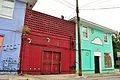
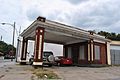
Gallery[]

Lakewood Heights Historic District

Lakewood Heights Historic District
Lakewood Heights Historic District

Lakewood Heights Historic District

Lakewood Heights Historic District
Lakewood Heights Historic District

Lakewood Heights Historic District

Lakewood Heights Historic District


See also[]
- Lakewood Fairgrounds
- Lakewood Assembly (GM plant)
References[]
- ^ "Lakewood Heights neighborhood in Atlanta, Georgia (GA), 30315 subdivision profile". www.city-data.com.
- ^ "National Register Information System". National Register of Historic Places. National Park Service. July 9, 2010.
- ^ "The South Bend Commons". southbend.co. Retrieved 2020-02-10.
- ^ Sustainable Lakewood: History of Lakewood Heights Archived 2010-05-22 at the Wayback Machine
- ^ Charles Forrest Palmer, Adventures of a Slum Fighter
- ^ Inc, Time (26 December 1938). "LIFE". Time Inc – via Google Books.
- ^ AP. "COMPANY NEWS; G.M. Will Close Factory in Atlanta". nytimes.com.
- ^ Atlanta Journal Constitution Radio & TV Talk blog: "EUE/Screen Gems studios at Lakewood in expansion mode", September 2011 Archived 2011-12-27 at the Wayback Machine
External links[]
- Lakewood Heights Civic Association
- Sustainable Lakewood: History of Lakewood Heights
- Friends of South Bend Park
Historic Districts in Metro Atlanta | ||
|---|---|---|
| Clayton County |
| |
| Cobb County |
| |
| Coweta County |
| |
| DeKalb County |
| |
| Douglas County |
| |
| Fulton County |
| |
| Gwinnett County |
| |
| Hall County |
| |
| Newton County |
| |
| Rockdale County |
| |
33°42′15″N 84°23′11″W / 33.704246°N 84.386413°WCoordinates: 33°42′15″N 84°23′11″W / 33.704246°N 84.386413°W
 WikiMiniAtlas
- African-American history in Atlanta
- Historic Jewish communities in the United States
- Jews and Judaism in Atlanta
- National Register of Historic Places in Atlanta
- Neighborhoods in Atlanta
- Streetcar suburbs
- Historic districts on the National Register of Historic Places in Georgia (U.S. state)
- Working-class culture in the United States