Lakhisarai district
Lakhisarai district | |
|---|---|
 | |
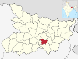 Location of Lakhisarai district in Bihar | |
| Country | India |
| State | Bihar |
| Division | Munger |
| Headquarters | Lakhisarai |
| Government | |
| • Lok Sabha constituencies | Munger |
| Area | |
| • Total | 1,228 km2 (474 sq mi) |
| Population (2011) | |
| • Total | 1,000,912 |
| • Density | 820/km2 (2,100/sq mi) |
| Demographics | |
| • Literacy | 64.95 per cent |
| • Sex ratio | 900 |
| Time zone | UTC+05:30 (IST) |
| Website | lakhisarai |
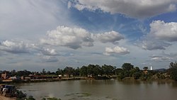
Lakhisarai district is one of the thirty-eight districts of Bihar state, India, and Lakhisarai town is the administrative headquarters of this district. Lakhisarai district is a part of Munger Division. The district occupies an area of 1,228 km2 (474 sq mi).
History[]
On 3 July 1994 this district was carved out from Munger district, which comprised the erstwhile Lakhisarai sub-division of the undivided district.
Geography[]
Lakhisarai district occupies an area of 1,228 square kilometres (474 sq mi),[1]
Economy[]
In 2006 the Ministry of Panchayati Raj named Lakhisarai one of the country's 250 districts (out of a total of 640).[2] It is one of the 36 districts in Bihar currently receiving funds from the Backward Regions Grant Fund Programme (BRGF).[2]
Industrial background; there are various fertilizer and pesticide factories in the district, including Bihar Mineral Industries. The market for fabrics in the district also flourishes with many old and new shops, and there are many factories like Sindur.
National Thermal Power Corporation Limited and Bihar State Power Generation Company Ltd has signed Memorandum of Understanding to set up 1320MW thermal power plant in Kajra.[3]
Divisions[]
This section does not cite any sources. (June 2013) |
The district consists only one sub-division Lakhisarai, which is divided into Seven developmental blocks, namely, Lakhisarai, Surajgarha, Barahiya, Halsi, Pipariya, Ramgarh Chowk and Chanan.
The district headquarters Lakhisarai is a city with mixed population, the majority being the upper-caste (Bhumihaar-Brahmins) people. Still under the process of development, the city has one newly constructed PCC road and a New bypass is constructed recently which gives some relaxation from traffic jams in the city . The Law and Order as well as development process is taking place during Nitish Kumar government's tenure. Also, Piribazar, Chanan police stations are naxal-prone due to their geographical layout. The city well known for its sindur (vermilion) production.
Religion[]
Lakhisarai is also famous for Indradameshwar Ashokdham temple, Bhagvati Sthan temple at Abhaipur, Abhaynath temple at the hills beside Abhaipur Village, Maharani temple at Barahiya, Shree Shesh Nag Temple at Babhangawan, Baba Govind temple at Mano-Rampur Rameshavar Dham Singarpur and for Shringirishi mountains and Surya Mandir at Pokhrama village in Alinagar Panchyat. This area is to be developed for Gautam Budha visits and related relics.
Demographics[]
| Year | Pop. | ±% p.a. |
|---|---|---|
| 1901 | 229,288 | — |
| 1911 | 236,466 | +0.31% |
| 1921 | 224,854 | −0.50% |
| 1931 | 253,195 | +1.19% |
| 1941 | 286,239 | +1.23% |
| 1951 | 316,343 | +1.01% |
| 1961 | 352,448 | +1.09% |
| 1971 | 439,256 | +2.23% |
| 1981 | 533,840 | +1.97% |
| 1991 | 646,395 | +1.93% |
| 2001 | 802,225 | +2.18% |
| 2011 | 1,000,912 | +2.24% |
| source:[4] | ||
According to the 2011 census Lakhisarai district has a population of 1,000,912,[5] This gives it a ranking of 445th in India (out of a total of 640).[5] The district has a population density of 815 inhabitants per square kilometre (2,110/sq mi) .[5] Its population growth rate over the decade 2001-2011 was 24.74%.[5] Lakhisarai has a sex ratio of 900 females for every 1000 males,[5] and a literacy rate of 64.95%. Scheduled Castes and Scheduled Tribes made up 15.3% and 0.8% of the population respectively.[5]
At the time of the 2011 Census of India, 97.28% of the population in the district spoke Hindi and 1.73% Urdu as their first language.[6] The main language is Magahi, but is counted as Hindi under the census.
Notable towns[]
Notable Person
- Giriraj Singh(politician)
- Dashrath Singh(Landlord)
- Devki Babu (Businessman)
- Sachin Bhardwaj(Eminent Law student)
Notable villages[]
External links[]
References[]
- ^ Srivastava, Dayawanti et al. (ed.) (2010). "States and Union Territories: Bihar: Government". India 2010: A Reference Annual (54th ed.). New Delhi, India: Additional Director General, Publications Division, Ministry of Information and Broadcasting (India), Government of India. pp. 1118–1119. ISBN 978-81-230-1617-7.
{{cite book}}:|last1=has generic name (help) - ^ a b Ministry of Panchayati Raj (September 8, 2009). "A Note on the Backward Regions Grant Fund Programme" (PDF). National Institute of Rural Development. Archived from the original (PDF) on April 5, 2012. Retrieved September 27, 2011.
- ^ "NTPC to set up 1,320-MW power plant in Bihar".
- ^ Decadal Variation In Population Since 1901
- ^ a b c d e f "District Census 2011". Census2011.co.in. 2011.
{{cite web}}: Missing or empty|url=(help) - ^ 2011 Census of India, Population By Mother Tongue
Places adjacent to Lakhisarai district | ||||||||||||||||
|---|---|---|---|---|---|---|---|---|---|---|---|---|---|---|---|---|
| ||||||||||||||||
| State symbols | |
|---|---|
| History |
|
| Administration |
|
| Overviews | |
| Divisions and districts | |
| Cities | |
| Municipal Corporation |
|
| Politics | |
| Culture |
|
Coordinates: 25°10′12″N 86°05′24″E / 25.17000°N 86.09000°E

- Lakhisarai district
- Munger division
- Districts of Bihar
- 1994 establishments in Bihar