Lanier Township, Preble County, Ohio
Lanier Township, Preble County, Ohio | |
|---|---|
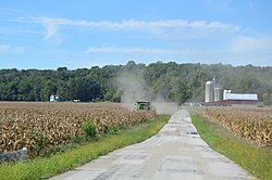 Corn harvest on Kinsey Road | |
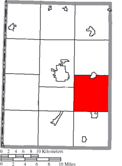 Location of Lanier Township in Preble County | |
| Coordinates: 39°42′38″N 84°31′47″W / 39.71056°N 84.52972°WCoordinates: 39°42′38″N 84°31′47″W / 39.71056°N 84.52972°W | |
| Country | United States |
| State | Ohio |
| County | Preble |
| Area | |
| • Total | 36.4 sq mi (94.2 km2) |
| • Land | 36.3 sq mi (94.1 km2) |
| • Water | 0.0 sq mi (0.0 km2) |
| Elevation | 886 ft (270 m) |
| Population (2000) | |
| • Total | 3,931 |
| • Density | 108.2/sq mi (41.8/km2) |
| Time zone | UTC-5 (Eastern (EST)) |
| • Summer (DST) | UTC-4 (EDT) |
| FIPS code | 39-41846[2] |
| GNIS feature ID | 1086852[1] |

Lanier Township is one of the twelve townships of Preble County, Ohio, United States. The 2000 census found 3,931 people in the township, 3,052 of whom lived in the unincorporated portions of the township.[3]
Geography[]
Located in the southeastern part of the county, it borders the following townships:
- Twin Township - north
- Perry Township, Montgomery County - northeast corner
- Jackson Township, Montgomery County - east
- German Township, Montgomery County - southeast corner
- Gratis Township - south
- Somers Township - southwest corner
- Gasper Township - west
- Washington Township - northwest
Part of the village of West Alexandria is located in northern Lanier Township.
Name and history[]
Lanier Township was founded in 1811, and named for Alexander C. Lanier, an early settler in Preble County.[4] It is the only Lanier Township statewide.[5]
Government[]
The township is governed by a three-member board of trustees, who are elected in November of odd-numbered years to a four-year term beginning on the following January 1. Two are elected in the year after the presidential election and one is elected in the year before it. There is also an elected township fiscal officer,[6] who serves a four-year term beginning on April 1 of the year after the election, which is held in November of the year before the presidential election. Vacancies in the fiscal officership or on the board of trustees are filled by the remaining trustees.
References[]
- ^ a b "US Board on Geographic Names". United States Geological Survey. 2007-10-25. Retrieved 2008-01-31.
- ^ "U.S. Census website". United States Census Bureau. Retrieved 2008-01-31.
- ^ Preble County, Ohio — Population by Places Estimates[permanent dead link] Ohio State University, 2007. Accessed 15 May 2007.
- ^ Kilbourn, John (1833). The Ohio Gazetteer, or, a Topographical Dictionary. Scott and Wright. pp. 266. Retrieved 12 December 2013.
- ^ "Detailed map of Ohio" (PDF). United States Census Bureau. 2000. Retrieved 2007-02-16.
- ^ §503.24, §505.01, and §507.01 of the Ohio Revised Code. Accessed 4/30/2009.
External links[]
Municipalities and communities of Preble County, Ohio, United States | ||
|---|---|---|
| City |  | |
| Villages | ||
| Townships | ||
| CDP | ||
| Unincorporated communities | ||
| Ghost towns | ||
| Footnotes | ‡This populated place also has portions in an adjacent county or counties | |
| ||
- Townships in Preble County, Ohio
- Townships in Ohio