Lauada, North Carolina
Lauada, North Carolina | |
|---|---|
Unincorporated community | |
 Lauada, North Carolina | |
| Coordinates: 35°22′22″N 83°30′15″W / 35.37278°N 83.50417°WCoordinates: 35°22′22″N 83°30′15″W / 35.37278°N 83.50417°W | |
| Country | United States |
| State | North Carolina |
| County | Swain |
| Elevation | 1,959 ft (597 m) |
| Time zone | UTC-5 (Eastern (EST)) |
| • Summer (DST) | UTC-4 (EDT) |
| Area code(s) | 828 |
| GNIS feature ID | 1012685[1] |


Lauada is an unincorporated community in Swain County, North Carolina, United States. Lauada is located at the junction of U.S. Route 19, U.S. Route 74, and North Carolina Highway 28 5.1 miles (8.2 km) southwest of Bryson City. The SCC Swain Center, a satellite location of Southwestern Community College, is located here.
History[]
Lauada Cemetery, located here, was created in 1943 during the construction of Fontana Lake to move grave sites from multiple cemeteries that now lie under the lake. [2] More than 1000 graves were moved to the cemetery upon its creation. [3]
References[]
- ^ "Lauada". Geographic Names Information System. United States Geological Survey.
- ^ Bowling, Caitlin (April 24, 2013). "Cemeteries ensconced by park remain a source of consternation". Smoky Mountain News. Retrieved 2020-05-28.
- ^ News Staff (April 28, 2021). "Outdoor Leadership Club lends helping hands to Lauada Cemetery". Smoky Mountain Times. Retrieved 2021-05-02.
Municipalities and communities of Swain County, North Carolina, United States | ||
|---|---|---|
| Town | 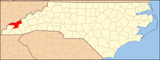 | |
| CDP | ||
| Unincorporated communities | ||
| Indian reservation | ||
| Footnotes | ‡This populated place also has portions in an adjacent county or counties | |
| ||
Categories:
- Unincorporated communities in Swain County, North Carolina
- Unincorporated communities in North Carolina
- Western North Carolina geography stubs