LeRoy (community), Wisconsin
LeRoy, Wisconsin | |
|---|---|
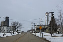 Looking north at LeRoy | |
 LeRoy Location within the state of Wisconsin | |
| Coordinates: 43°34′24″N 88°33′38″W / 43.57333°N 88.56056°WCoordinates: 43°34′24″N 88°33′38″W / 43.57333°N 88.56056°W | |
| Country | |
| State | |
| County | Dodge |
| Town | LeRoy |
| Elevation | 1,050 ft (320 m) |
| Time zone | UTC-6 (Central (CST)) |
| • Summer (DST) | UTC-5 (CDT) |
| ZIP codes | 53048 |
| Area code(s) | 920 |

LeRoy is an unincorporated community in the town of LeRoy in Dodge County, Wisconsin, United States.[1] It is located at the intersection of County Y and County YY several miles west of Knowles.[2][3]

Looking east at downtown LeRoy

Looking north at LeRoy's welcome sign

St. Andrew's Church, listed on the National Register of Historic Places


References[]
- ^ "LeRoy, Wisconsin". Geographic Names Information System. United States Geological Survey.
- ^ "Location of LeRoy". Mapquest. Retrieved 20 April 2010.
- ^ 2001-2 Wisconsin Road Map. State of Wisconsin.
Municipalities and communities of Dodge County, Wisconsin, United States | ||
|---|---|---|
| Cities |  | |
| Villages | ||
| Towns | ||
| CDPs | ||
| Other communities |
| |
| Ghost towns | ||
| Footnotes | ‡This populated place also has portions in an adjacent county or counties | |
| ||
This article about a location in Dodge County, Wisconsin is a stub. You can help Wikipedia by . |
Categories:
- Unincorporated communities in Dodge County, Wisconsin
- Unincorporated communities in Wisconsin
- South Central Wisconsin geography stubs