Horicon, Wisconsin
Horicon, Wisconsin | |
|---|---|
 Looking west at downtown Horicon | |
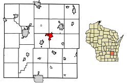 Location of Horicon in Dodge County, Wisconsin. | |
| Coordinates: 43°27′N 88°39′W / 43.450°N 88.650°WCoordinates: 43°27′N 88°39′W / 43.450°N 88.650°W | |
| Country | |
| State | |
| County | Dodge |
| Area | |
| • Total | 3.64 sq mi (9.42 km2) |
| • Land | 3.50 sq mi (9.05 km2) |
| • Water | 0.14 sq mi (0.37 km2) |
| Elevation | 883 ft (269 m) |
| Population | |
| • Total | 3,655 |
| • Estimate (2019)[5] | 3,645 |
| • Density | 1,042.62/sq mi (402.54/km2) |
| Time zone | UTC-6 (Central (CST)) |
| • Summer (DST) | UTC-5 (CDT) |
| Area code(s) | 920 |
| FIPS code | 55-35750[4] |
| GNIS feature ID | 1566696[3] |
| Website | cityhoriconwi |

Horicon is a city in Dodge County, Wisconsin, United States. The population was 3,655 at the 2010 census.
Geography[]
Horicon is located at 43°27′N 88°39′W / 43.450°N 88.650°W (43.4482, -88.6329).[6] According to the United States Census Bureau, the city has a total area of 3.42 square miles (8.86 km2), of which, 3.21 square miles (8.31 km2) is land and 0.21 square miles (0.54 km2) is water.[7]
The city is situated at the southernmost tip of the Horicon Marsh. Tourists flock to the area every year to see the migration of the Canada geese.
Demographics[]
| Historical population | |||
|---|---|---|---|
| Census | Pop. | %± | |
| 1880 | 1,250 | — | |
| 1890 | 1,354 | 8.3% | |
| 1900 | 1,376 | 1.6% | |
| 1910 | 1,881 | 36.7% | |
| 1920 | 2,134 | 13.5% | |
| 1930 | 2,214 | 3.7% | |
| 1940 | 2,253 | 1.8% | |
| 1950 | 2,664 | 18.2% | |
| 1960 | 2,996 | 12.5% | |
| 1970 | 3,356 | 12.0% | |
| 1980 | 3,584 | 6.8% | |
| 1990 | 3,873 | 8.1% | |
| 2000 | 3,775 | −2.5% | |
| 2010 | 3,655 | −3.2% | |
| 2019 (est.) | 3,645 | [5] | −0.3% |
| U.S. Decennial Census[8] | |||
2010 census[]
As of the census[2] of 2010, there were 3,655 people, 1,497 households, and 1,006 families living in the city. The population density was 1,138.6 inhabitants per square mile (439.6/km2). There were 1,620 housing units at an average density of 504.7 per square mile (194.9/km2). The racial makeup of the city was 95.7% White, 0.4% African American, 0.1% Native American, 0.7% Asian, 1.6% from other races, and 1.5% from two or more races. Hispanic or Latino of any race were 4.1% of the population.
There were 1,497 households, of which 31.5% had children under the age of 18 living with them, 53.3% were married couples living together, 9.2% had a female householder with no husband present, 4.7% had a male householder with no wife present, and 32.8% were non-families. 27.0% of all households were made up of individuals, and 9.5% had someone living alone who was 65 years of age or older. The average household size was 2.42 and the average family size was 2.94.
The median age in the city was 38.7 years. 24.2% of residents were under the age of 18; 7.9% were between the ages of 18 and 24; 26.7% were from 25 to 44; 27.9% were from 45 to 64; and 13.4% were 65 years of age or older. The gender makeup of the city was 50.1% male and 49.9% female.
2000 census[]
As of the census[4] of 2000, there were 3,775 people, 1,474 households, and 1,037 families living in the city. The population density was 1,126.8 people per square mile (435.1/km2). There were 1,584 housing units at an average density of 472.8 per square mile (182.6/km2). The racial makeup of the city was 97.59% White, 0.40% African American, 0.19% Native American, 0.19% Asian, 0.08% Pacific Islander, 1.03% from other races, and 0.53% from two or more races. 2.09% of the population were Hispanic or Latino of any race.
There were 1,474 households, out of which 34.8% had children under the age of 18 living with them, 58.5% were married couples living together, 7.7% had a female householder with no husband present, and 29.6% were non-families. 25.4% of all households were made up of individuals, and 10.5% had someone living alone who was 65 years of age or older. The average household size was 2.56 and the average family size was 3.06.
In the city, the population was spread out, with 26.6% under the age of 18, 8.5% from 18 to 24, 30.3% from 25 to 44, 22.0% from 45 to 64, and 12.7% who were 65 years of age or older. The median age was 36 years. For every 100 females, there were 98.6 males. For every 100 females age 18 and over, there were 97.3 males.
The median income for a household in the city was $50,577, and the median income for a family was $58,393. Males had a median income of $38,008 versus $26,278 for females. The per capita income for the city was $21,690. 2.1% of the population and 0.6% of families were below the poverty line. Out of the total population, 1.6% of those under the age of 18 and 0.4% of those 65 and older were living below the poverty line.
Economy[]

Horicon is home of the John Deere Horicon Works, which produces lawn and garden tractors, golf and turf reel mowers, and utility vehicles. , the inventor of the grain-drill and founder of what became John Deere Horicon Works, also founded Horicon Bank in 1896.
The Dodge County Pionier took over the Horicon Reporter in 2009 to cover news in Horicon and the surrounding area.
Education[]
The School District of Horicon serves the area.[9] It consists of Van Brunt Elementary School and Horicon High School, whose mascot is the Marshmen.
Horicon Public Library[]
The Horicon Public Library is a member of the Mid-Wisconsin Federated Library System (MWFLS) and is in the Trio consortium, which shares materials with various other public and school libraries throughout Dodge, Jefferson, and Washington Counties in southeastern Wisconsin.[10] The small-town evaluation program "First Impressions," a program for community assessment and improvement, in 2009, stated that the Horicon Public Library was "outstanding."[11]
Notable people[]
- Hiram Barber, businessman and politician
- Hiram Barber, Jr, U.S. Representative from Illinois
- Satterlee Clark, Jr, member of the Wisconsin State Assembly and Wisconsin State Senator[12]
- Charles Hawks, Jr., U.S. Representative
- S. H. Hays, Idaho politician
- James B. Hays, attorney, politician, and jurist in Wisconsin and the Idaho Territory
- Charles A. Kading, U.S. Representative
- Adrian Karsten, ESPN reporter
- Esther Doughty Luckhardt, member of the Wisconsin State Assembly
- William H. Markham, member of the Wisconsin State Senator
- Bradley Phillips, member of the Wisconsin State Assembly
- Theodore Schroeder, lawyer and writer[13]
- Fran Ulmer, Alaskan politician.[14]
Images[]

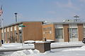
City hall

Looking west at the sign for Horicon on WIS 33
Post office

Horicon Works, a John Deere plant in Horicon
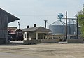
Train depot


References[]
- ^ "2019 U.S. Gazetteer Files". United States Census Bureau. Retrieved August 7, 2020.
- ^ Jump up to: a b "U.S. Census website". United States Census Bureau. Retrieved 2012-11-18.
- ^ Jump up to: a b "US Board on Geographic Names". United States Geological Survey. 2007-10-25. Retrieved 2008-01-31.
- ^ Jump up to: a b "U.S. Census website". United States Census Bureau. Retrieved 2008-01-31.
- ^ Jump up to: a b "Population and Housing Unit Estimates". United States Census Bureau. May 24, 2020. Retrieved May 27, 2020.
- ^ "US Gazetteer files: 2010, 2000, and 1990". United States Census Bureau. 2011-02-12. Retrieved 2011-04-23.
- ^ "US Gazetteer files 2010". United States Census Bureau. Archived from the original on 2012-01-24. Retrieved 2012-11-18.
- ^ "Census of Population and Housing". Census.gov. Retrieved June 4, 2015.
- ^ School District of Horicon
- ^ Mid-Wisconsin Federated Library System http://www.mwfls.org/memberlibraries.asp, SHARE Libraries https://www.sharelibraries.info
- ^ Teams offer ways to make Horicon more attractive http://www.wiscnews.com/bdc/news/local/article_dd953e87-4e37-5e56-98b5-736fc2a325ea.html
- ^ Lyman Copeland Draper (ed.). Collections of the State Historical Society of Wisconsin. Vol. IX. Madison: State Historical Society of Wisconsin, 1882, p. 462.
- ^ "Schroeder, Albert Theodore | Southern Illinois University Special Collections Research Center". archives.lib.siu.edu. Retrieved 2018-06-10.
- ^ Ulmer, Fran (1998). "Lieutenant Governor Fran Ulmer, Democrat". Alaska Division of Elections. Retrieved July 30, 2017.
External links[]
| Wikimedia Commons has media related to Horicon, Wisconsin. |
- City of Horicon
- Horicon Chamber of Commerce
- Sanborn fire insurance maps: 1894 1904 1913
| show Municipalities and communities of Dodge County, Wisconsin, United States |
|---|

| show Authority control |
|---|
- Cities in Wisconsin
- Cities in Dodge County, Wisconsin