Les Plus Beaux Villages de Wallonie

From Wikipedia, the free encyclopedia
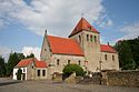
Sign outside Thon-Samson describing it as "One of the Most Beautiful Villages of Wallonia"

Les Plus Beaux Villages de Wallonie (French; in English: "The Most Beautiful Villages of Wallonia") is a non-profit organisation formed in 1994[1] to promote, protect and develop a number of villages in Wallonia, Belgium.

The association is inspired by the organisation Les plus beaux villages de France[2] and is established as an ASBL in Belgium.

Les Plus Beaux Villages de Wallonie organises events such as Un Dimanche, un Beau Village ("one Sunday, one beautiful village"), where one village is highlighted and promoted each week, and activities take place to allow visitors to explore the culture and heritage of the village.[2]
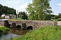
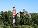
List of villages[]

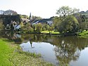
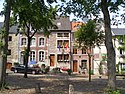
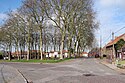
The following villages are presently members of Les Plus Beaux Villages de Wallonie:[3]

Map all coordinates using: OpenStreetMap 
Download coordinates as: KML
Name Province Municipality Location Image
Aubechies
Hainaut
Wapen van Henegouwen (provincie).svg
Belœil
50°34′26″N 03°40′37″E / 50.57389°N 3.67694°E / 50.57389; 3.67694 (Aubechies)
0 Aubechies - Église Saint-Géry (2).jpg
(More images)
Barbençon
Hainaut
Wapen van Henegouwen (provincie).svg
Beaumont
50°13′14″N 04°17′09″E / 50.22056°N 4.28583°E / 50.22056; 4.28583 (Barbençon)
Barbençon Ch1JPG.jpg
(More images)
Celles
Namur
Wapen van Namen (provincie).svg
Houyet
50°13′45″N 05°00′29″E / 50.22917°N 5.00806°E / 50.22917; 5.00806 (Celles)
ID91072-PEX-0001-02 Celles-lez-Dinant PM 35427.jpg
(More images)
Chardeneux
Namur
Wapen van Namen (provincie).svg
Somme-Leuze
50°22′26″N 05°21′50″E / 50.37389°N 5.36389°E / 50.37389; 5.36389 (Chardeneux)
Chardeneux JPG01.jpg
(More images)
Chassepierre
Luxembourg
Coat of arms of the Province of Luxembourg.svg
Florenville
49°42′25″N 05°15′39″E / 49.70694°N 5.26083°E / 49.70694; 5.26083 (Chassepierre)
Chassepierre - Vi02 JPG.jpg
(More images)
Clermont-sur-Berwinne
Liège
Wapen van Luik (provincie).svg
Thimister-Clermont
50°39′32″N 05°53′06″E / 50.65889°N 5.88500°E / 50.65889; 5.88500 (Clermont-sur-Berwinne)
Thimister-Clermont-Town hall of Clermont (1).jpg
(More images)
Crupet
Namur
Wapen van Namen (provincie).svg
Assesse
50°20′56″N 04°57′36″E / 50.34889°N 4.96000°E / 50.34889; 4.96000 (Crupet)
Crupet Castle R05.jpg
(More images)
Falaën
Namur
Wapen van Namen (provincie).svg
Onhaye
50°16′43″N 04°47′36″E / 50.27861°N 4.79333°E / 50.27861; 4.79333 (Falaën)
Falaën 060823 (5).JPG
(More images)
 [fr]
Namur
Wapen van Namen (provincie).svg
Bièvre
49°52′12″N 04°59′02″E / 49.87000°N 4.98389°E / 49.87000; 4.98389 (Gros-Fays)
Gros-Fays 060505 (8).jpg
(More images)
Laforêt
Namur
Wapen van Namen (provincie).svg
Vresse-sur-Semois
49°53′16″N 04°56′38″E / 49.88778°N 4.94389°E / 49.88778; 4.94389 (Laforêt)
Laforêt 060504 (9).JPG
(More images)
Limbourg
Liège
Wapen van Luik (provincie).svg
Limbourg
50°36′43″N 05°56′24″E / 50.61194°N 5.94000°E / 50.61194; 5.94000 (Limbourg)
2010.07.21.120154 Place Saint-Georges Limbourg Belgien.jpg
(More images)
Lompret
Hainaut
Wapen van Henegouwen (provincie).svg
Chimay
50°03′51″N 04°22′44″E / 50.06417°N 4.37889°E / 50.06417; 4.37889 (Lompret)
Lompret JPG06.jpg
(More images)
Mélin
Walloon Brabant
Arms of Walloon Brabant.svg
Jodoigne
50°44′27″N 04°49′48″E / 50.74083°N 4.83000°E / 50.74083; 4.83000 (Mélin)
Mélin JPG08.jpg
(More images)
 [fr]
Luxembourg
Coat of arms of the Province of Luxembourg.svg
Saint-Hubert
50°03′25″N 05°15′46″E / 50.05694°N 5.26278°E / 50.05694; 5.26278 (Mirwart)
Mirwart JPG02.jpg
(More images)
Montignies-sur-Roc
Hainaut
Wapen van Henegouwen (provincie).svg
Honnelles
50°22′04″N 03°43′59″E / 50.36778°N 3.73306°E / 50.36778; 3.73306 (Montignies-sur-Roc)
Place Masson à Montignies-sur-roc.jpg
(More images)
Mozet
Namur
Wapen van Namen (provincie).svg
Gesves
50°26′31″N 04°59′09″E / 50.44194°N 4.98583°E / 50.44194; 4.98583 (Mozet)
0 Mozet - Ferme-château Marchand (1).jpg
(More images)
Nobressart
Luxembourg
Coat of arms of the Province of Luxembourg.svg
Attert
49°44′24″N 05°43′08″E / 49.74000°N 5.71889°E / 49.74000; 5.71889 (Nobressart)
Nobressart JPG05.jpg
(More images)
Ny
Luxembourg
Coat of arms of the Province of Luxembourg.svg
Hotton
50°17′06″N 05°28′52″E / 50.28500°N 5.48111°E / 50.28500; 5.48111 (Ny)
Ny JPG01.jpg
(More images)
Our
Luxembourg
Coat of arms of the Province of Luxembourg.svg
Paliseul
49°57′32″N 05°07′26″E / 49.95889°N 5.12389°E / 49.95889; 5.12389 (Ny)
Our PO1aJPG.jpg
(More images)
Olne
Liège
Wapen van Luik (provincie).svg
Olne
50°34′48″N 05°45′00″E / 50.58000°N 5.75000°E / 50.58000; 5.75000 (Our)
Olne, stadhuis foto2 2010-07-10 12.53.JPG
(More images)
Ragnies
Hainaut
Wapen van Henegouwen (provincie).svg
Thuin
50°18′30″N 04°17′02″E / 50.30833°N 4.28389°E / 50.30833; 4.28389 (Ragnies)
Ragnies JPG00.jpg
(More images)
Sohier
Luxembourg
Coat of arms of the Province of Luxembourg.svg
Wellin
50°04′04″N 05°04′15″E / 50.06778°N 5.07083°E / 50.06778; 5.07083 (Sohier)
SohierKerk2.JPG
(More images)
Soiron
Liège
Wapen van Luik (provincie).svg
Pepinster
50°35′31″N 05°47′27″E / 50.59194°N 5.79083°E / 50.59194; 5.79083 (Soiron)
0 Soiron - Village (1).JPG
(More images)
Sosoye
Namur
Wapen van Namen (provincie).svg
Anhée
50°17′45″N 04°46′58″E / 50.29583°N 4.78278°E / 50.29583; 4.78278 (Sosoye)
Sosoye panorama.JPG
(More images)
 [fr]
Namur
Wapen van Namen (provincie).svg
Doische
50°11′20″N 04°44′09″E / 50.18889°N 4.73583°E / 50.18889; 4.73583 (Soulme)
Moulin soulme2.JPG
(More images)
Thon-Samson
Namur
Wapen van Namen (provincie).svg
Andenne
50°27′58″N 05°00′43″E / 50.46611°N 5.01194°E / 50.46611; 5.01194 (Thon-Samson)
Thon 050818 (33).JPG
(More images)
Torgny
Luxembourg
Coat of arms of the Province of Luxembourg.svg
Rouvroy
49°30′25″N 05°28′33″E / 49.50694°N 5.47583°E / 49.50694; 5.47583 (Torgny)
Torgny JPG02 050615.jpg
(More images)
Vierves-sur-Viroin
Namur
Wapen van Namen (provincie).svg
Viroinval
50°04′51″N 04°38′02″E / 50.08083°N 4.63389°E / 50.08083; 4.63389 (Vierves-sur-Viroin)
Vierves-sur-Viroin JPG05.jpg
(More images)
Wéris
Luxembourg
Coat of arms of the Province of Luxembourg.svg
Durbuy
50°19′33″N 05°31′53″E / 50.32583°N 5.53139°E / 50.32583; 5.53139 (Wéris)
0 Wéris 050307 (24).JPG
(More images)

See also[]

References[]

  1. ^ "BrusselsLife : Les Plus Beaux Villages de Wallonie" (in French). Archived from the original on 2013-06-27. Retrieved 2013-04-15.
  2. ^ Jump up to: a b "Rural Success Story" (PDF). European Commission. 2006. p. 7. Archived from the original (PDF) on 2011-05-19. Retrieved 2007-03-14.
  3. ^ "The villages". Official site of Les Plus Beaux Villages de Wallonie. Les Plus Beaux Villages de Wallonie a.s.b.l. Retrieved 13 July 2021.

External links[]

Retrieved from ""