Pepinster
Pepinster
Pepinster (Walloon) | |
|---|---|
 | |
 Pepinster Location in Belgium
show Location of Pepinster in the province of Liège | |
| Coordinates: 50°34′N 05°49′E / 50.567°N 5.817°ECoordinates: 50°34′N 05°49′E / 50.567°N 5.817°E | |
| Country | Belgium |
| Community | French Community |
| Region | |
| Province | Liège |
| Arrondissement | Verviers |
| Government | |
| • Mayor | Philippe Godin |
| Area | |
| • Total | 24.79 km2 (9.57 sq mi) |
| Population (2018-01-01)[1] | |
| • Total | 9,765 |
| • Density | 390/km2 (1,000/sq mi) |
| Postal codes | 4860-4861 |
| Area codes | 087 |
| Website | www.pepinster.be |


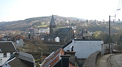
Pepinster (French pronunciation: [pepɛ̃stɛʁ]) is a municipality of Wallonia located in the province of Liège, Belgium.
On January 1, 2006, Pepinster had a total population of 9,560. The total area is 24.79 km² which gives a population density of 386 inhabitants per km². Pepinster is situated at the confluence of the rivers Hoëgne and Vesdre.
The municipality consists of the following districts: Cornesse, Pepinster, Soiron, Tancrémont, and Wegnez.
Pepinster got hit extremely hard by the 2021 European floods.
Image gallery[]
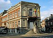
Pepinster town hall

The romanesque Christ (11th century).

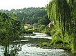
the Vesdre river


See also[]
- Fort de Tancrémont, a companion to Fort Eben-Emael, located just outside the town
- List of protected heritage sites in Pepinster
References[]
- ^ "Wettelijke Bevolking per gemeente op 1 januari 2018". Statbel. Retrieved 9 March 2019.
External links[]
 Media related to Pepinster at Wikimedia Commons
| show Places adjacent to Pepinster |
|---|
| show Municipalities in the province of liège, Wallonia |
|---|

| show Authority control |
|---|
This Liège Province location article is a stub. You can help Wikipedia by . |
Categories:
- Pepinster
- Municipalities of Liège (province)
- Liège geography stubs