Theux
Theux
Teu (Walloon) | |
|---|---|
 Place du Perron | |
 Flag  Coat of arms | |
 Theux Location in Belgium
show Location of Theux in the province of Liège | |
| Coordinates: 50°32′N 05°49′E / 50.533°N 5.817°ECoordinates: 50°32′N 05°49′E / 50.533°N 5.817°E | |
| Country | Belgium |
| Community | French Community |
| Region | |
| Province | Liège |
| Arrondissement | Verviers |
| Government | |
| • Mayor | Philippe Boury |
| Area | |
| • Total | 83.36 km2 (32.19 sq mi) |
| Population (2018-01-01)[1] | |
| • Total | 12,025 |
| • Density | 140/km2 (370/sq mi) |
| Postal codes | 4910 |
| Area codes | 087 |
| Website | www.theux.be |


Theux (Walloon: Teu) is a municipality of Wallonia located in the province of Liège, Belgium.
On 1 January 2006 the municipality had 11,571 inhabitants. The total area is 83.36 km², giving a population density of 139 inhabitants per km².
The municipality consists of the following districts: La Reid, and Polleur, and Theux.
History[]
In World War II, the 75th Division of the U.S. Army, , maintained its command post in the town from January 10–12, 1945, as it counterattacked against the German army in the Battle of the Bulge.
Notable buildings[]
- Franchimont Castle is located in Theux municipality.
- A Perron, symbol of the town's status.
- , in the hamlet of Tancrémont.
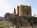
Franchimont Castle

Theux Perron
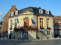
Town Hall of Theux


See also[]
References[]
- ^ "Wettelijke Bevolking per gemeente op 1 januari 2018". Statbel. Retrieved 9 March 2019.
External links[]
 Media related to Theux at Wikimedia Commons
| show Places adjacent to Theux |
|---|
| show Municipalities in the province of liège, Wallonia |
|---|

| show Authority control |
|---|
This Liège Province location article is a stub. You can help Wikipedia by . |
Categories:
- Municipalities of Liège (province)
- Liège geography stubs