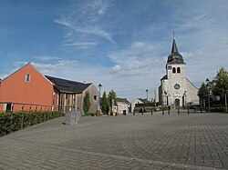
Lontzen
Lontzen | |
|---|---|
 | |
 Flag Coat of arms | |
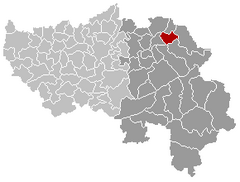
 Lontzen Location in Belgium
show Location of Lontzen in the province of Liège | |
| Coordinates: 50°41′N 06°00′E / 50.683°N 6.000°ECoordinates: 50°41′N 06°00′E / 50.683°N 6.000°E | |
| Country | Belgium |
| Community | |
| Region | |
| Province | Liège |
| Arrondissement | Verviers |
| Government | |
| • Mayor | Patrick Thevissen (PFF) |
| • Governing party/ies | PFF, Ecolo |
| Area | |
| • Total | 28.73 km2 (11.09 sq mi) |
| Population (2018-01-01)[1] | |
| • Total | 5,695 |
| • Density | 200/km2 (510/sq mi) |
| Postal codes | 4710-4711 |
| Area codes | 087 |
| Website | www.lontzen.be |

Lontzen is a municipality located in East Belgium. On January 1, 2006 Lontzen had a total population of 5,071. The total area is 28.73 km² which gives a population density of 177 inhabitants per km².
The municipality consists of the following sub-municipalities: Lontzen proper, Herbesthal, and Walhorn.
In the 19th century, a Low Franconian dialect was widely spoken in Lontzen.
See also[]
References[]
- ^ "Wettelijke Bevolking per gemeente op 1 januari 2018". Statbel. Retrieved 9 March 2019.
External links[]
 Media related to Lontzen at Wikimedia Commons
- Official web page (in German and French)
| show Places adjacent to Lontzen |
|---|
| show Municipalities in the province of liège, Wallonia |
|---|

| show Authority control |
|---|
This Liège Province location article is a stub. You can help Wikipedia by . |
Categories:
- Lontzen
- Liège geography stubs