Donceel
Donceel
Doncél (Walloon) | |
|---|---|
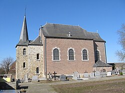 Church of Saint-Cyr and Sainte Juliette | |
 Flag  Coat of arms | |
 Donceel Location in Belgium
Location of Donceel in the province of Liège  | |
| Coordinates: 50°39′N 05°19′E / 50.650°N 5.317°ECoordinates: 50°39′N 05°19′E / 50.650°N 5.317°E | |
| Country | Belgium |
| Community | French Community |
| Region | |
| Province | Liège |
| Arrondissement | Waremme |
| Government | |
| • Mayor | Michel Paulus (IC) |
| • Governing party/ies | IC |
| Area | |
| • Total | 23.31 km2 (9.00 sq mi) |
| Population (2018-01-01)[1] | |
| • Total | 3,048 |
| • Density | 130/km2 (340/sq mi) |
| Postal codes | 4357 |
| Area codes | 04 |
| Website | www.donceel.be |

Donceel (French pronunciation: [dɔ̃sel]; Walloon: Doncél) is a municipality of Wallonia located in the province of Liège, Belgium.
On January 1, 2006, Donceel had a total population of 2,828. The total area is 23.31 km² which gives a population density of 121 inhabitants per km².
The municipality consists of the following districts: Donceel, , , and .
Image gallery[]

Haneffe, church

Jeneffe, church


See also[]
References[]
- ^ "Wettelijke Bevolking per gemeente op 1 januari 2018". Statbel. Retrieved 9 March 2019.
External links[]
 Media related to Donceel at Wikimedia Commons
Places adjacent to Donceel | |
|---|---|

This Liège Province location article is a stub. You can help Wikipedia by . |
Categories:
- Municipalities of Liège (province)
- Liège geography stubs