Paliseul
Paliseul
Palijhoû (Walloon) | |
|---|---|
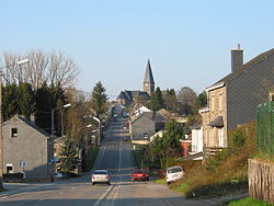 Bouillon Street | |
 Flag  Coat of arms | |
 Paliseul Location in Belgium
Location of Paliseul in Luxembourg province  | |
| Coordinates: 49°54′N 05°08′E / 49.900°N 5.133°ECoordinates: 49°54′N 05°08′E / 49.900°N 5.133°E | |
| Country | Belgium |
| Community | French Community |
| Region | |
| Province | Luxembourg |
| Arrondissement | Neufchâteau |
| Government | |
| • Mayor | Jean Pol Hannard (Plus) |
| • Governing party/ies | Plus, Ensemble |
| Area | |
| • Total | 112.96 km2 (43.61 sq mi) |
| Population (2018-01-01)[1] | |
| • Total | 5,393 |
| • Density | 48/km2 (120/sq mi) |
| Postal codes | 6850-6853, 6856 |
| Area codes | 061 |
| Website | (in French) paliseul.be |

Paliseul (Walloon: Palijhoû) is a municipality of Wallonia located in the province of Luxembourg, Belgium.
On 1 January 2007 the municipality, which covers 112.96 km², had 5,055 inhabitants, giving a population density of 44.8 inhabitants per km².
The municipality consists of the following districts: , , , , , , , and Paliseul. Other population centers include: Beth, Bour, Merny, Our, and Plainevaux.
Gallery[]

Paliseul, church (l'église Saint Eutrope)

Plainevaux, church (l'église Saint Barbe)

Nollevaux, church (l'église Saint-Urbain)


See also[]
References[]
- ^ "Wettelijke Bevolking per gemeente op 1 januari 2018". Statbel. Retrieved 9 March 2019.
External links[]
 Media related to Paliseul at Wikimedia Commons
Municipalities of the province of Luxembourg, Wallonia | ||
|---|---|---|
| Arlon |  | |
| Bastogne |
| |
| Marche-en-Famenne | ||
| Neufchâteau |
| |
| Virton | ||
This Belgian Luxembourg location article is a stub. You can help Wikipedia by . |
Categories:
- Paliseul
- Municipalities of Luxembourg (Belgium)
- Belgian Luxembourg geography stubs