Neufchâteau, Luxembourg Province
Neufchâteau | |
|---|---|
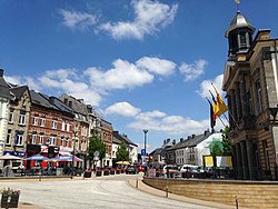 Grand-Place, the town centre | |
 Coat of arms | |
 Neufchâteau Location in Belgium
show The commune and its district in the province of Luxembourg | |
| Coordinates: 49°50′N 05°26′E / 49.833°N 5.433°ECoordinates: 49°50′N 05°26′E / 49.833°N 5.433°E | |
| Country | Belgium |
| Community | French Community |
| Region | |
| Province | Luxembourg |
| Arrondissement | Neufchâteau |
| Government | |
| • Mayor | Michèle Mons Delle Roche (Pour vous) |
| • Governing party/ies | Pour vous - 3ème Piste |
| Area | |
| • Total | 113.79 km2 (43.93 sq mi) |
| Population (2018-01-01)[1] | |
| • Total | 7,679 |
| • Density | 67/km2 (170/sq mi) |
| Postal codes | 6840 |
| Area codes | 061 - 063 |
| Website | neufchateau.be - |


Neufchâteau (Walloon: Li Tchestea) is a city and municipality of Wallonia located in the province of Luxembourg, Belgium.
On 1 January 2007 the municipality, which covers 113.79 km², had 6,652 inhabitants, giving a population density of 58.5 inhabitants per km².
It includes the former municipalities of Grandvoir, Grapfontaine, Hamipré, Longlier, and Tournay, as well as the localities of Cousteumont, Fineuse, Gérimont, Harfontaine, Hosseuse, Lahérie, LeSart, Malome, Marbay, Massul, Molinfaing, MonIdée, Montplainchamps, Morival, Namoussart, Nolinfaing, Offaing, Petitvoir, Respelt, Semel, Tronquoy, Verlaine, and Warmifontaine.
History[]
Early history[]
A Neolithic megalith dating from about 2000 BC and a Celtic necropolis dating from between the 5th and 2nd centuries BC have been found in this area, attesting to early human activity. Gallo-Roman sepultures and a small Roman villa were found here as well, showing the presence around the 2nd century AD of a minor agricultural domain. The region was used in Carolingian times mostly as a hunting area and population remained sparse throughout the Middle Ages. A document dating from 1100 shows that one of the many tiny hamlets in the area, Semel, was donated to the Abbey of Amdain (currently Saint-Hubert). In 1239, that same hamlet was mentioned as being part of the lordship of Neufchâteau, at the time when it was now given to the Orval Abbey. Like many of its neighbours, the lordship of Neufchâteau was part of the Duchy of Luxembourg.
17th century until now[]
An important document for the history of the Neufchâteu region is a 1609 painting entitled “LA TERRE ET PREVOSTEE DE NEVFCHASTEAV AVECQZ SES DESPENDENCES", now kept in the Arlon archives. The painting shows the town of Neufchâteau within its protective walls, at the foot of its castle, surrounded by a number of villages and hamlets. In the mid-17th century, the plague and Louis XIV’s wars decimated the area. After the French Revolution and until 1815, Neufchâteau became the chief town of the old French département of Forêts. During World War I, its governor, Count Hans von Blumenthal, was one of a small number of German military officials who struck up a rapport with the local population, chiefly through his interest in hunting. Fighting in the area, however, was heavy, as more than 200 soldiers lost their lives in the first month of the war.
Sights[]
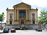
The hall of justice

Griffon Tower, the only remnant of the castle

The Church in Neufchâteau-town

The church in Longlier

View of part of the town


- The city hall, law courts, and main church
- The Griffon tower, last remnant of the medieval castle that gave the city its name
- The rural-life museum
- Lake Neufchâteau
Climate[]
| hideClimate data for Neufchateau | |||||||||||||
|---|---|---|---|---|---|---|---|---|---|---|---|---|---|
| Month | Jan | Feb | Mar | Apr | May | Jun | Jul | Aug | Sep | Oct | Nov | Dec | Year |
| Average high °C (°F) | 3 (37) |
4 (40) |
7 (44) |
12 (54) |
17 (63) |
21 (69) |
21 (70) |
21 (69) |
18 (64) |
12 (54) |
7 (44) |
3 (37) |
12 (54) |
| Average low °C (°F) | −4 (24) |
−3 (27) |
−2 (29) |
2 (36) |
7 (44) |
9 (48) |
10 (50) |
10 (50) |
7 (45) |
4 (40) |
1 (33) |
−3 (26) |
3 (38) |
| Average precipitation mm (inches) | 91 (3.6) |
41 (1.6) |
61 (2.4) |
61 (2.4) |
58 (2.3) |
79 (3.1) |
110 (4.4) |
81 (3.2) |
66 (2.6) |
120 (4.7) |
84 (3.3) |
100 (4.1) |
960 (37.8) |
| Source: Weatherbase [2] | |||||||||||||
References[]
- ^ "Wettelijke Bevolking per gemeente op 1 januari 2018". Statbel. Retrieved 9 March 2019.
- ^ "Weatherbase: Historical Weather for Neufchateau, Belgium". Weatherbase. 2011. Retrieved on November 24, 2011.
- Gourdet L. and Geubel A., Histoire du Pays de Neufchâteau, Gembloux, 1956, 467 p., in-8º, cited in fr:Carte d'Arenberg de la Prévôté de Neufchâteau en 1609.
External links[]
| Wikimedia Commons has media related to Neufchâteau (Luxembourg Province). |
| show Places adjacent to Neufchâteau, Luxembourg Province |
|---|
| show Municipalities of Luxembourg Province, Wallonia |
|---|

| Authority control |
|
|---|
- Neufchâteau, Luxembourg Province
- Cities in Wallonia
- Municipalities of Luxembourg (Belgium)