Étalle, Belgium
Étalle | |
|---|---|
 | |
 Flag  Coat of arms | |
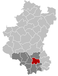
 Étalle Location in Belgium
show Location of Étalle in Luxembourg province | |
| Coordinates: 49°41′N 05°36′E / 49.683°N 5.600°ECoordinates: 49°41′N 05°36′E / 49.683°N 5.600°E | |
| Country | Belgium |
| Community | French Community |
| Region | |
| Province | Luxembourg |
| Arrondissement | Virton |
| Government | |
| • Mayor | Henry Thiry |
| • Governing party/ies | Mayeur |
| Area | |
| • Total | 78.10 km2 (30.15 sq mi) |
| Population (2018-01-01)[1] | |
| • Total | 5,855 |
| • Density | 75/km2 (190/sq mi) |
| Postal codes | 6740-6743 |
| Area codes | 063 |
| Website | etalle |

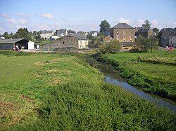
Étalle (Lorrain: Ètaule) is a municipality of Wallonia located in the province of Luxembourg, Belgium.
On 1 January 2007 the municipality, which covers 78.1 km2, had 5,389 inhabitants, giving a population density of 69 inhabitants per km2.
The municipality consists of the following districts: Buzenol, Chantemelle, Étalle, Sainte-Marie, Vance, and Villers-sur-Semois. Other population centers include: Croix Rouge, Fratin, Huombois, and Sivry.
See also[]
References[]
- ^ "Wettelijke Bevolking per gemeente op 1 januari 2018". Statbel. Retrieved 9 March 2019.
External links[]
 Media related to Étalle, Belgium at Wikimedia Commons
| show Places adjacent to Étalle, Belgium |
|---|
| show Municipalities of Luxembourg Province, Wallonia |
|---|

| show Authority control |
|---|
This Belgian Luxembourg location article is a stub. You can help Wikipedia by . |
Categories:
- Étalle, Belgium
- Municipalities of Luxembourg (Belgium)
- Belgian Luxembourg geography stubs