Saint-Léger, Belgium
Saint-Léger
Sint-Ldjir-e-Gåme (Walloon) | |
|---|---|
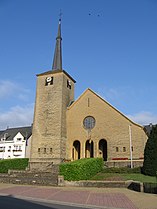 The church | |
 Flag  Coat of arms | |
 Saint-Léger Location in Belgium
show Location of Saint-Léger in Luxembourg province | |
| Coordinates: 49°37′N 05°39′E / 49.617°N 5.650°ECoordinates: 49°37′N 05°39′E / 49.617°N 5.650°E | |
| Country | Belgium |
| Community | French Community |
| Region | |
| Province | Luxembourg |
| Arrondissement | Virton |
| Government | |
| • Mayor | Alain Rongvaux (Avenir) |
| • Governing party/ies | Avenir |
| Area | |
| • Total | 35.86 km2 (13.85 sq mi) |
| Population (2018-01-01)[1] | |
| • Total | 3,592 |
| • Density | 100/km2 (260/sq mi) |
| Postal codes | 6747 |
| Area codes | 063 |
| Website | (in French) saint-leger.be |


Saint-Léger (also unofficial Saint-Léger-en-Gaume; Walloon: Sint-Ldjir-e-Gåme) is a municipality of Wallonia located in the province of Luxembourg, Belgium.
On 1 January 2007 the municipality, which covers 35.86 km2, had 3,225 inhabitants, giving a population density of 89.9 inhabitants per km2.
The municipality consists of the districts of Châtillon, Meix-le-Tige, and Saint-Léger.
References[]
- ^ "Wettelijke Bevolking per gemeente op 1 januari 2018". Statbel. Retrieved 9 March 2019.
External links[]
 Media related to Saint-Léger-en-Gaume at Wikimedia Commons
| show Places adjacent to Saint-Léger, Belgium |
|---|
| show Municipalities of Luxembourg Province, Wallonia |
|---|

| Authority control |
|
|---|
This Belgian Luxembourg location article is a stub. You can help Wikipedia by . |
Categories:
- Saint-Léger, Belgium
- Municipalities of Luxembourg (Belgium)
- Belgian Luxembourg geography stubs