Lety (Písek District)
Lety | |
|---|---|
Municipality | |
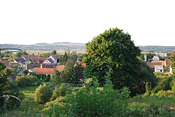 View on the part of the village | |
 Lety | |
| Coordinates: 49°31′1″N 14°5′16″E / 49.51694°N 14.08778°ECoordinates: 49°31′1″N 14°5′16″E / 49.51694°N 14.08778°E | |
| Country | |
| Region | South Bohemian |
| District | Písek |
| Area | |
| • Total | 13.92 km2 (5.37 sq mi) |
| Elevation | 450 m (1,480 ft) |
| Population (2005) | |
| • Total | 285 |
| • Density | 20/km2 (53/sq mi) |
| Postal code | 39807 |
| Website | http://www.lety-obec.cz/ |

Lety is a village and municipality (obec) in Písek District in the South Bohemian Region of the Czech Republic. The municipality covers an area of 13.92 square kilometres (5.37 sq mi), and has a population of 285 (as at 2005).
Lety lies approximately 25 kilometres (16 mi) north of Písek, 67 km (42 mi) north-west of České Budějovice, and 68 km (42 mi) south of Prague.
The hamlets Pukňov and Šerkov are administrative parts of Lety.
During World War II a concentration camp was established near Lety. The camp is most known for its role as a Gypsy camp. See concentration camps Lety and Hodonín for details.
References[]
| Wikimedia Commons has media related to Lety (Písek District). |
| show Authority control |
|---|
This South Bohemian Region location article is a stub. You can help Wikipedia by . |
Categories:
- Villages in Písek District
- South Bohemian Region geography stubs