Tálín
Tálín | |
|---|---|
Municipality | |
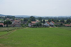 General view of the village | |
 Flag  Coat of arms | |
 Tálín | |
| Coordinates: 49°14′51″N 14°13′38″E / 49.24750°N 14.22722°ECoordinates: 49°14′51″N 14°13′38″E / 49.24750°N 14.22722°E | |
| Country | |
| Region | South Bohemian |
| District | Písek |
| Area | |
| • Total | 4.19 km2 (1.62 sq mi) |
| Elevation | 393 m (1,289 ft) |
| Population (2005) | |
| • Total | 158 |
| • Density | 38/km2 (98/sq mi) |
| Postal code | 398 11 |
| Website | http://www.talin.cz/ |

Tálín (German: Talin) is a village and municipality (obec) in Písek District in the South Bohemian Region of the Czech Republic.
The municipality covers an area of 4.19 square kilometres (1.62 sq mi), and has a population of 158 (as at 2005).
Tálín lies approximately 9 kilometres (6 mi) south-east of Písek, 36 km (22 mi) north-west of České Budějovice, and 95 km (59 mi) south of Prague.
References[]
| Wikimedia Commons has media related to Tálín. |
| Authority control: National libraries |
|---|
This South Bohemian Region location article is a stub. You can help Wikipedia by . |
Categories:
- Villages in Písek District
- South Bohemian Region geography stubs