Albrechtice nad Vltavou
Albrechtice nad Vltavou | |
|---|---|
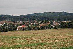 Panorama of Albrechtice nad Vltavou | |
 Flag  Coat of arms | |
 Albrechtice nad Vltavou Location in the Czech Republic | |
| Coordinates: 49°15′12″N 14°18′10″E / 49.25333°N 14.30278°ECoordinates: 49°15′12″N 14°18′10″E / 49.25333°N 14.30278°E | |
| Country | |
| Region | South Bohemian |
| District | Písek |
| First mentioned | 1352 |
| Area | |
| • Total | 36.71 km2 (14.17 sq mi) |
| Elevation | 428 m (1,404 ft) |
| Population (2021-01-01)[1] | |
| • Total | 946 |
| • Density | 26/km2 (67/sq mi) |
| Time zone | UTC+1 (CET) |
| • Summer (DST) | UTC+2 (CEST) |
| Postal code | 398 16 |
| Website | www |

Albrechtice nad Vltavou is a municipality and village in Písek District in the South Bohemian Region of the Czech Republic. It has about 900 inhabitants.
Albrechtice nad Vltavou lies approximately 14 kilometres (9 mi) south-east of Písek, 34 km (21 mi) north of České Budějovice, and 93 km (58 mi) south of Prague.
Administrative parts[]
Villages of Hladná, Chřešťovice, Jehnědno, Údraž and Újezd are administrative parts of Albrechtice nad Vltavou.
Sights[]
The major sight is a Romanesque Church of Saints Peter and Paul from the late 12th century with a churchyard. The walls of the churchyard have a unique arcade decoration with paintings and moralizing verses from the 19th century.[2]
Twin towns – sister cities[]
Albrechtice nad Vltavou is twinned with:[3]
 Siselen, Switzerland
References[]
- ^ "Population of Municipalities – 1 January 2021". Czech Statistical Office. 2021-04-30.
- ^ "Kostel sv. Petra a Pavla" (in Czech). Obec Albrechtice nad Vltavou. 2021-08-26.
- ^ "Návštěva v Siselenu" (in Czech). Obec Albrechtice nad Vltavou. Retrieved 2020-08-23.
External links[]
| Wikimedia Commons has media related to Albrechtice nad Vltavou. |
- Official website (in Czech)
| Authority control: National libraries |
|---|
This South Bohemian Region location article is a stub. You can help Wikipedia by . |
- Villages in Písek District
- South Bohemian Region geography stubs