Lewiston–Clarkston metropolitan area
Lewiston–Clarkston metropolitan area | |
|---|---|
| Lewiston, ID–WA Metropolitan Statistical Area | |
  A map of the Lewiston, ID-WA MSA. | |
| Coordinates: 46°N 117°W / 46°N 117°W | |
| Country | United States |
| State(s) | Idaho, Washington |
| Largest city | Lewiston (32,873) |
| Other cities | Clarkston (7,341) |
| Area | |
| • Total | 1,497 sq mi (3,880 km2) |
| Population | |
| • Total | 62,675 |
| • Rank | 380th in the U.S. |
| • Density | 41.9/sq mi (16.6/km2) |

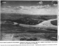
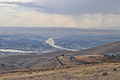
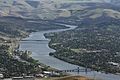
The Lewiston–Clarkston metropolitan area—colloquially referred to as the Lewiston–Clarkston Valley or Lewis–Clark Valley (often abbreviated as LC Valley), and officially known as the Lewiston, ID–WA Metropolitan Statistical Area—is an metropolitan area comprising Nez Perce County, Idaho and Asotin County, Washington. The metro is anchored by the cities of Lewiston, Idaho and Clarkston, Washington—named after Meriwether Lewis and William Clark,[A] respectively. As of the 2010 census, the MSA had a population of 60,888 (though a July 1, 2011 estimate placed the population at 61,476),[1] making it the 3rd smallest metropolitan area in the United States.
Geography[]
Counties[]
Communities[]
- Anatone, Washington (unincorporated)
- Asotin, Washington
- Clarkston Heights-Vineland, Washington (unincorporated)
- Clarkston, Washington
- Culdesac, Idaho
- Lapwai, Idaho
- Lewiston, Idaho (Principal city)
- Peck, Idaho
- Spalding, Idaho (unincorporated)
- West Clarkston-Highland, Washington (unincorporated)
Features[]
- Lewiston Hill
- Lower Granite Lake
- Snake River
- Clearwater River (Idaho)
- Bridges
- Highways
- U.S. Route 12 in Washington
- U.S. Route 12 in Idaho
- U.S. Route 95 in Idaho
Photos[]


Demographics[]
As of the census of 2000, there were 57,961 people, 23,650 households, and 15,803 families residing within the MSA. The racial makeup of the MSA was 93.01% White, 0.25% African American, 3.88% Native American, 0.60% Asian, 0.06% Pacific Islander, 0.55% from other races, and 1.66% from two or more races. Hispanic or Latino of any race were 1.94% of the population.
The median income for a household in the MSA was $34,903, and the median income for a family was $42,402. Males had a median income of $35,249 versus $24,616 for females. The per capita income for the MSA was $18,146.
See also[]
- Idaho census statistical areas
- Washington census statistical areas
Notes[]
- ^ of the Lewis and Clark Expedition
References[]
- ^ "Table 1. Annual Estimates of the Population of Metropolitan and Micropolitan Statistical Areas: April 1, 2010 to July 1, 2011 (CBSA-EST2011-01)". 2011 Population Estimates. United States Census Bureau, Population Division. 2012-09-14. Archived from the original (CSV) on April 27, 2012. Retrieved 2012-09-14.
- ^ Thain Road up to the "Lewiston Orchards" is often referred to as "Thain Grade": https://www.openstreetmap.org/way/256628692
| show |
|---|


| Authority control |
|
|---|
- Lewiston–Clarkston metropolitan area
- Regions of Idaho
- Regions of Washington (state)
- Metropolitan areas of Idaho
- Metropolitan areas of Washington (state)
- Twin cities