List of CTrain stations
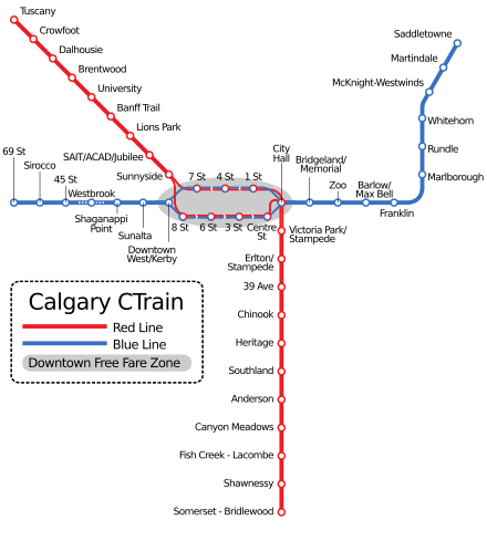
CTrain is a light rail system in Calgary, Alberta, Canada. It has been in operation since May 25, 1981.[1] The system is operated by Calgary Transit, as part of the Calgary municipal government's transportation department.[2] The CTrain system has two routes, with a combined route length of 59.9 kilometres (37.2 mi).[3] The Red Line (also known as Route 201) is 35 kilometres (22 mi) long and serves the southern and northwestern areas of the city. The Blue Line (also known as Route 202) is 25.7 kilometres (16.0 mi) long, and serves the northeastern and western sections of the city.[4]
Most CTrain track is at grade, within its own right-of-way. The downtown portion services both transit lines along the 7th Avenue South transit mall at street level, and is shared between the CTrain, Calgary Transit buses, and City of Calgary vehicles. This portion is a zero-fare zone and serves as a downtown people mover. The tracks split at the east and west ends of downtown into lines leading to the south, northeast, west and northwest residential neighbourhoods of Calgary. Six percent of the system is underground, and seven percent is grade-separated (elevated).[4] Trains are powered by overhead electric wires, using pantographs to draw power.
List of CTrain stations[]
- Key
| † | Terminus |
| * | 7 Avenue Free Fare Zone |
| R | Red Line |
| B | Blue Line |
Active stations[]
| Station | Route | Grade | Opened | Platform type | Parking spaces[5] |
|---|---|---|---|---|---|
| Tuscany† | R | At-grade | 2014 | Centre | 572 |
| Crowfoot | R | At-grade | 2009 | Centre | 1345 |
| Dalhousie | R | At-grade | 2003 | Centre | 740 |
| Brentwood | R | At-grade | 1990 | Centre | 980 |
| University | R | At-grade | 1987 | Centre | None |
| Banff Trail | R | At-grade | 1987 | Side-loading | 700 (at McMahon Stadium) |
| Lions Park | R | At-grade | 1987 | Side-loading | None |
| SAIT/AUArts/Jubilee | R | At-grade | 1987 | Centre | None |
| Sunnyside | R | At-grade | 1987 | Side-loading | None |
| 8 Street SW* | R B | At-grade | 1981 | Side-loading (eastbound) | None |
| 7 Street SW* | R B | At-grade | 1981 | Side-loading (westbound) | None |
| 6 Street SW* | R B | At-grade | 1981 | Side-loading (eastbound) | None |
| 4 Street SW* | R B | At-grade | 1981 | Side-loading (westbound) | None |
| 3 Street SW* | R B | At-grade | 1981 | Side-loading (eastbound) | None |
| 1 Street SW* | R B | At-grade | 1981 | Side-loading (westbound) | None |
| Centre St.* | R B | At-grade | 1981 | Side-loading (eastbound) | None |
| City Hall* | R B | At-grade | 1981 | Side-loading | None |
| Victoria Park/Stampede | R | At-grade | 1981 | Centre Side-loading (overflow) | None |
| Erlton/Stampede | R | At-grade | 1981 | Centre | None |
| 39 Avenue | R | At-grade | 1981 | Side-loading | 297 |
| Chinook | R | At-grade | 1981 | Centre | 320 |
| Heritage | R | At-grade | 1981 | Centre | 550 |
| Southland | R | At-grade | 1981 | Centre | 680 |
| Anderson | R | At-grade | 1981 | Centre | 1750 |
| Canyon Meadows | R | At-grade | 2001 | Centre | 260 |
| Fish Creek–Lacombe | R | At-grade | 2001 | Centre | 1130 |
| Shawnessy | R | At-grade | 2004 | Staggered side-loading | 200 |
| Somerset–Bridlewood† | R | At-grade | 2004 | Centre | 913 |
| 69 Street† | B | Trenched | 2012 | Centre | 827 |
| Sirocco | B | At-grade | 2012 | Side-loading | 365 |
| 45 Street | B | Trenched | 2012 | Side-loading | None |
| Westbrook | B | Underground | 2012 | Side-loading | None |
| Shaganappi Point | B | At-grade | 2012 | Side-loading | None |
| Sunalta | B | Elevated | 2012 | Side-loading | None |
| Downtown West–Kerby* | B | At-grade | 2012 | Side-loading | None |
| Bridgeland/Memorial | B | At-grade | 1985 | Centre | None |
| Zoo | B | At-grade | 1985 | Centre | 500 (at Calgary Zoo) |
| Barlow/Max Bell | B | At-grade | 1985 | Centre | 50 |
| Franklin | B | At-grade | 1985 | Centre | 578 |
| Marlborough | B | At-grade | 1985 | Centre | 480 |
| Rundle | B | At-grade | 1985 | Centre | 350 |
| Whitehorn | B | At-grade | 1985 | Centre | 824 |
| McKnight–Westwinds | B | At-grade | 2007 | Centre | 949 |
| Martindale | B | At-grade | 2012 | Side-loading | None |
| Saddletowne† | B | At-grade | 2012 | Centre | 130 |
Former stations[]
| Station | Route | Area | Open | Closed |
|---|---|---|---|---|
| 3 Street SE | B | Downtown | 1985 | 2010 |
| Olympic Plaza | R B | Downtown | 1981 | 2011 |
| 10 Street SW | B | Downtown | 1985 | 2012 |
Ghost station[]
| Station | Area | Open | Location |
|---|---|---|---|
| Calgary Municipal Building | Downtown | Future | Planned subway line under 8th Ave |
This underground station was built under the Municipal Building as part of a proposed future 8th Avenue subway. There is a short section of unused transit tunnel leading to it from the South leg that was blocked off after underground urban explorers started following it into the station.
References[]
- ^ "About Calgary Transit / Corporate Information / History". Calgary Transit. City of Calgary. 2014. Retrieved 2015-03-15.
- ^ "The City of Calgary Transportation Department". City of Calgary (website). Retrieved 2012-10-16.
- ^ "About Calgary Transit / Facts and Figures / Statistics". Calgary Transit. City of Calgary. 2015. Retrieved 2015-07-17.
- ^ a b "LRT Technical Data". Calgary Transit. City of Calgary. Archived from the original on 2014-07-14.
- ^ Calgary Transit. "Park & Ride Locations - Calgary Transit". www.calgarytransit.com. Retrieved 2 February 2018.
- CTrain
- Light rail in Canada
- Lists of railway stations in Canada
- Lists of metro stations
- Calgary-related lists