List of Indian states and union territories by highest point
This is the alphabetical list of the highest points of the Indian states and union territories.
States[]
| Rank | States | Peak | Range/Region | Height (m) | Height (ft) | Coordinates | Source |
|---|---|---|---|---|---|---|---|
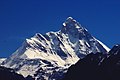
| 1 | Sikkim | Kangchenjunga (shared with Nepal) | Eastern Himalayas | 8,586 | 28,169 | 27°42′11″N 88°08′53″E / 27.703°N 88.148°E | Kangchenjunga lies on the India–Nepal border. It is the highest mountain peak located in India and the third highest mountain peak in the world after Mount Everest and K2.[1] |
| 2 | Uttarakhand | Nanda Devi | Garhwal Himalaya section of the Western Himalayas | 7,817 | 25,646 | 30°22′34″N 79°58′12″E / 30.376°N 79.970°E | Nanda Devi is the highest peak located entirely within India.[2] |
| 3 | Arunachal Pradesh | Kangto (shared with China) | Eastern Himalayas | 7,060 | 23,160 | Kangto lies along the Line of Actual Control between India and China. | |
| 4 | Himachal Pradesh | Reo Purgyil (shared with China) | Western Himalayas | 6,813 | 22,362 | 31°53′02″N 78°44′06″E / 31.884°N 78.735°E | Reo Purgyil lies along the Line of Actual Control between India and China. |
| 5 | Nagaland | Mount Saramati (shared with Myanmar) | Naga Hills section of the Purvanchal Range | 3,841 | 12,602 | 25°44′31″N 95°01′59″E / 25.742°N 95.033°E | Mount Saramati lies on the India–Myanmar border. It is the highest peak in the Purvanchal Range.[3] |
| 6 | West Bengal | Sandakphu (shared with Nepal) | Singalila Ridge section of the Eastern Himalayas | 3,636 | 11,929 | 27°06′22″N 88°00′07″E / 27.106°N 88.002°E | Sandakphu lies on the India–Nepal border.[4] |
| 7 | Manipur | Mount Tempü (also known as Mount Iso) | Naga Hills section of the Purvanchal Range | 2,994 | 9,823 | 25°31′52″N 94°05′06″E / 25.531°N 94.085°E | [5][6] |
| 8 | Kerala | Anamudi | Anamalai Hills section of the Western Ghats | 2,695 | 8,842 | 10°10′12″N 77°03′40″E / 10.170°N 77.061°E | Anamudi is the highest peak in the Western Ghats and highest in India outside the Himalayas.[7] |
| 9 | Tamil Nadu | Doddabetta | Nilgiri Hills section of the Western Ghats | 2,636 | 8,648 | 11°24′04″N 76°44′10″E / 11.401°N 76.736°E | [8] |
| 10 | Mizoram | Phawngpui | Lushai Hills section of the Purvanchal Range | 2,165 | 7,103 | 22°37′53″N 93°02′20″E / 22.6315°N 93.0388°E | [9] |
| 11 | Meghalaya | Khasi Hills section of the Shillong Plateau | 1,965 | 6,447 | 25°31′54″N 91°51′04″E / 25.5316°N 91.8512°E | Shillong Peak is the highest peak in the Shillong Plateau.[10] | |
| 12 | Assam | Unnamed peak | section of the Karbi Anglong Plateau | 1,960 | 6,430 | 25°19′17″N 93°27′10″E / 25.32135°N 93.4529°E | Located in Dima Hasao District.[11] |
| 13 | Karnataka | Mullayanagiri | section of the Western Ghats | 1,925 | 6,317 | 13°23′28″N 75°43′16″E / 13.391°N 75.721°E | [12] |
| 14 | Rajasthan | Guru Shikhar | Aravalli Range | 1,722 | 5,650 | 24°39′00″N 72°46′34″E / 24.650°N 72.776°E | Guru Shikhar is the highest peak in the Aravalli Range.[13] |
| 15 | Andhra Pradesh | Arma Konda | Eastern Ghats | 1,680 | 5,512 | 18°13′41″N 82°43′23″E / 18.228°N 82.723°E | Arma Konda is the highest peak in the Eastern Ghats.[14][15] |
| 16 | Odisha | Deomali | Eastern Ghats | 1,672 | 5,486 | 18°40′30″N 82°58′55″E / 18.675°N 82.982°E | [16] |
| 17 | Maharashtra | Kalsubai | Sahyadri Hills section of the Western Ghats | 1,646 | 5,400 | 19°36′01″N 73°42′40″E / 19.6003°N 73.711°E | [17] |
| 18 | Haryana | Karoh Peak | Morni Hills section of the Sivalik Hills | 1,499 | 4,918 | 30°44′37″N 77°04′37″E / 30.7437°N 77.0769°E | [18] |
| 19 | Jharkhand | Parasnath | Chota Nagpur Plateau | 1,382 | 4,482 | 23°57′48″N 86°07′44″E / 23.9634°N 86.129°E | Parasnath is the highest peak in the Chota Nagpur Plateau.[19] |
| 20 | Madhya Pradesh | Dhupgarh | Satpura Range | 1,352 | 4,435 | 22°26′56″N 78°22′16″E / 22.449°N 78.371°E | Dhupgarh is the highest peak in the Satpura Range.[20] |
| 21 | Chhattisgarh | Unnamed peak | Bailadila Range section of the Deccan Plateau | 1,276 | 4,186 | 18°39′53″N 81°13′33″E / 18.6646°N 81.2258°E | Located in Dantewada District. The highest named peak in Chhattisgarh is with the elevation of 1225 m (4019 ft).[21][22][23] |
| 22 | Gujarat | Girnar | Girnar Hills | 1,145 | 3,756 | 21°31′41″N 70°31′38″E / 21.5281°N 70.527199°E | Girnar is the highest peak in the Girnar Hills.[24] |
| 23 | Goa | Sonsogor | Western Ghats | 1,022 | 3,353 | 15°31′24″N 74°16′46″E / 15.5232°N 74.2795°E | [25] |
| 24 | Punjab | Unnamed peak | section of the Sivalik Hills | 1,000 | 3,281 | 31°15′32″N 76°36′04″E / 31.259°N 76.601°E | Located in Rupnagar District.[26] |
| 25 | Telangana | Doli Gutta | Deccan Plateau | 965 | 3,166 | 18°20′31″N 80°44′29″E / 18.34194°N 80.74139°E | [27] |
| 26 | Uttar Pradesh | section of the Sivalik Hills | 957 | 3,140 | 30°22′47″N 77°41′11″E / 30.3798°N 77.6865°E | [28] | |
| 27 | Tripura | Betlingchhip | Jampui Hills section of the Purvanchal Range | 930 | 3,051 | 23°48′35″N 92°15′39″E / 23.809782°N 92.260971°E | [29] |
| 28 | Bihar | Someshwar Fort | Sivalik Hills | 880 | 2,887 | 27°23′15″N 84°18′20″E / 27.3876°N 84.3055°E | [30] |

Union territories[]
| Rank | Union Territory | Peak | Range/Region | Height (m) | Height (ft) | Coordinates | Source |
|---|---|---|---|---|---|---|---|
| 1 | Ladakh | Saltoro Kangri (shared with Pakistan) | Saltoro Range section of the Karakoram | 7,742 | 25,400 | 35°23′56″N 76°50′56″E / 35.399°N 76.849°E | Saltoro Kangri lies along the Actual Ground Position Line between India and Pakistan on the Siachen Glacier. The highest peak claimed by India as part of Ladakh is K2 which has the elevation of 8,611 m (28,251 ft). K2 is located in the Pakistan-administered territory of Gilgit-Baltistan.[31][32][33] |
| 2 | Jammu and Kashmir | Nun Peak | Western Himalayas | 7,135 | 23,409 | 33°58′51″N 76°01′14″E / 33.9809°N 76.0205°E | [34] |
| 3 | Andaman and Nicobar Islands | Saddle Peak | North Andaman Island | 732 | 2,402 | 13°09′31″N 93°00′21″E / 13.1586°N 93.0058°E | [35] |
| 4 | Dadra and Nagar Haveli and Daman and Diu | Unnamed point | Western Ghats | 424 | 1,391 | Located in Dadra and Nagar Haveli District.[citation needed] | |
| 5 | Chandigarh | Unnamed point | Sivalik Hills | 383 | 1,257 | [citation needed] | |
| 6 | Delhi | Tughlaqabad Fort | Delhi Ridge section of the Aravalli Range | 319 | 1,047 | [citation needed] | |
| 7 | Puducherry | Unnamed point | Red Hills | 30 | 98 | [citation needed] | |
| 8 | Lakshadweep | Unnamed point | Agatti Island | 15 | 49 |
Gallery[]

Kangchenjunga (8,586 m)
Nanda Devi (7,816 m)
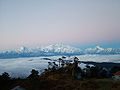
Sandakphu (3,636 m)
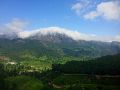
Anamudi (2,695 m)
Gurushikhar Mount Abu (1,722 m)

Kalsubai (1,646 m)


See also[]
- List of hill stations in India
- List of mountains in India
- List of the tallest statues in India
- List of tallest buildings in India
- List of tallest structures in India
- Rameswaram TV Tower, tallest Towers in India
- Tourism in India
References[]
- ^ "Kangchenjunga - Peakware". Archived from the original on 2009-02-20. Retrieved 2008-12-27.
- ^ "Nanda Devi - Peakware".
- ^ "Saramati". Peakbagger.com.
- ^ "Sandakphu". Archived from the original on 2008-12-25.
- ^ "Hills Of Manipur". Archived from the original on 2013-03-23.
- ^ "Manipur Tourism District:Senapati". Archived from the original on 2017-04-03. Retrieved 2014-10-14.
- ^ "Anai Mudi". Peakbagger.com.
- ^ "A Beautiful Green Hills". Archived from the original on 2007-09-29.
- ^ "Phawngpui, Mizoram". Archived from the original on 2009-05-02. Retrieved 2008-12-27.
- ^ The Rough Guide to India. Rough Guides. 1 October 2013. pp. 963–. ISBN 978-1-4093-4267-0.
- ^ "Assam Hills". Birdlife International.
- ^ Ganesh Prabhu (2014-03-19). "Udupi-Chikmagalur: A constituency that's beset by problems". The Hindu.
- ^ "Guru Shikhar, Mount Abu". Archived from the original on 2009-04-10.
- ^ The Geography of India: Sacred and Historic Places
- ^ The britannica Quiqmaster
- ^ "Deomali Peak in Koraput".
- ^ "Kalsubai". Archived from the original on 2011-07-22. Retrieved 2008-12-27.
- ^ Bijender K Punia (1994). Tourism Management: Problems and Prospects. APH Publishing. pp. 21–. ISBN 978-81-7024-643-5.
- ^ "Parasnath". Archived from the original on 2005-10-18.
- ^ M.S. Kohli (2002). Mountains of India: Tourism, Adventure and Pilgrimage. Indus Publishing. p. 39. ISBN 978-81-7387-135-1.
- ^ छत्तीसगढ़ के सर्वोच्च शिखर गौरलाटा पर 5 वर्ष की एडविना कांत
- ^ "National Mineral Development Corporation, Dantewada district, Chhattisgarh". Archived from the original on 2017-03-01. Retrieved 2014-11-06.
- ^ Bailadila Hills, Dantewada district, Chhattisgarh
- ^ Background Information about the State of Gujarat Archived 2017-08-20 at the Wayback Machine, dgfasli.nic.in
- ^ "The tiger in the tale". The Times of India. 2011-12-12.
- ^ "GAZETTEER RUPNAGAR". Archived from the original on 2016-07-16. Retrieved 2014-09-25.
- ^ "Wikimapia - Doli Gutta (965m) - Telangana Chhattisgarh border. Possibly highest point in Telangana".
- ^ "Highest Peaks in India".
- ^ "Peakbagger - Betalongchhip, India".
- ^ Fort Someshwar, West Champaran district, Bihar
- ^ "Saltoro Kangri, Pakistan/India". Peakbagger.com.
- ^ "Top 10 highest Himalaya mountain peaks in India".
- ^ "Top 10 highest peaks of India".
- ^ "Nun, India". Peakbagger.com.
- ^ "Saddle Peak -- Britannica".
| hide | |
|---|---|
| By state |
|
| Types |
|
| Organisations |
|
| See also |
|
| |
Categories:
- States and union territories of India-related lists
- India geography-related lists
- Highest points of Indian states and union territories
- Lists of subdivisions of India
- Lists of highest points in Asia