List of Indiana state historical markers in Clay County

Location of Clay County in Indiana
This is a list of the Indiana state historical markers in Clay County.
This is intended to be a complete list of the official state historical markers placed in Clay County, Indiana, United States by the Indiana Historical Bureau. The locations of the historical markers and their latitude and longitude coordinates are included below when available, along with their names, years of placement, and topics as recorded by the Historical Bureau. There are 3 historical markers located in Clay County.[1]
Historical markers[]
| Marker title | Image | Year placed | Location | Topics |
|---|---|---|---|---|
| Crosscut Canal/Eel River Feeder Dam[2] | 
|
1999 | 4 miles north of Clay City at the northwestern corner of the State Road 59 bridge over the Eel River 39°20′22″N 87°6′36″W / 39.33944°N 87.11000°W |
Transportation, Business, Industry, and Labor |
| Crosscut Canal[3] | 1999 | 6.5 miles south of Clay City on State Road 59 at County Road 1300S, at the northwestern corner of the old K and E Canal bridge 39°11′42″N 87°7′43″W / 39.19500°N 87.12861°W |
Business, Industry, and Labor, Transportation | |
| Clay County Courthouse[4] | 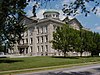
|
2001 | 609 E. National Road/U.S. Route 40 in Brazil 39°31′28″N 87°7′10″W / 39.52444°N 87.11944°W |
Government Institutions, Buildings and Architecture |

See also[]
- List of Indiana state historical markers
- National Register of Historic Places listings in Clay County, Indiana
References[]
- ^ "Indiana Historical Markers by County". State of Indiana. Retrieved 2012-03-15.
- ^ Crosscut Canal/Eel River Feeder Dam, Indiana Historical Bureau, n.d. Accessed 2012-03-14.
- ^ Crosscut Canal, Indiana Historical Bureau, n.d. Accessed 2012-03-14.
- ^ Clay County Courthouse, Indiana Historical Bureau, n.d. Accessed 2012-03-14.
External links[]
Municipalities and communities of Clay County, Indiana, United States | ||
|---|---|---|
| City | ||
| Towns | ||
| Townships | ||
| CDP | ||
| Other unincorporated communities |
| |
| Ghost towns | ||
| Footnotes | ‡This populated place also has portions in an adjacent county or counties | |
| ||
Categories:
- Indiana state historical markers
- Tourist attractions in Clay County, Indiana