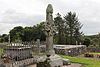
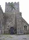
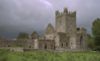
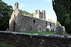
List of National Monuments in County Kilkenny
The Irish state has officially approved the following List of National Monuments in County Kilkenny. In the Republic of Ireland, a structure or site may be deemed to be a "National Monument", and therefore worthy of state protection, if it is of national importance. If the land adjoining the monument is essential to protect it, this land may also be protected.
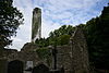
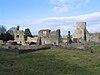
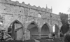
National Monuments[]


See also[]
- List of National Monuments of Ireland
References[]
- "National Monuments in State Care: Ownership & Guardianship 4th March 2009 - Kilkenny" (PDF). Ireland: National Monuments Service. Retrieved 12 October 2020.
- "National Monuments in State Care: Ownership & Guardianship Kilkenny" (PDF). archaeology.ie. National Monuments Service. 2009.

Categories:
- National Monuments in County Kilkenny
- Archaeological sites in County Kilkenny
- Lists of National Monuments of Ireland
- County Kilkenny-related lists