NM#
Monument name
Description
Image
Townland
Location
Alexander Reid mound Barrow mound 53°39′04″N 6°37′48″W / 53.651231°N 6.629919°W / 53.651231; -6.629919 546 Ardmulchan Passage Tomb Passage Tomb 53°40′58″N 6°36′35″W / 53.682740°N 6.609606°W / 53.682740; -6.609606 496 Ardmulchan Fort Ringfort 53°40′28″N 6°37′36″W / 53.674472°N 6.626735°W / 53.674472; -6.626735 239 Cannistown Church Church 53°37′07″N 6°40′05″W / 53.618507°N 6.667935°W / 53.618507; -6.667935 539 Athcarne Castle Castle 53°37′19″N 6°26′29″W / 53.621945°N 6.441283°W / 53.621945; -6.441283 287 Athlumney Castle Castle 53°39′01″N 6°40′30″W / 53.650258°N 6.675125°W / 53.650258; -6.675125 186, 468 The Yellow Steeple & Nangle Castle Priory (Augustinian) & Castle Trim 53°33′23″N 6°47′19″W / 53.556454°N 6.788628°W / 53.556454; -6.788628 356 Balrath Cross Cross 53°37′25″N 6°29′18″W / 53.623686°N 6.488256°W / 53.623686; -6.488256 187 Bective Abbey Abbey (Cistercian) Bective 53°34′58″N 6°42′10″W / 53.582653°N 6.702748°W / 53.582653; -6.702748 469 Sheep Gate Town Defences Trim 53°33′19″N 6°47′16″W / 53.555280°N 6.787879°W / 53.555280; -6.787879 637 Calliaghstown Well (St. Columcille's Well)Holy Well 53°40′17″N 6°19′46″W / 53.671492°N 6.329380°W / 53.671492; -6.329380 544 Carrickdexter Cross (Baronstown Cross)Stone cross (early 17th century) 53°42′11″N 6°34′57″W / 53.702968°N 6.582497°W / 53.702968; -6.582497 676,148 Hill of Tara Ritual & burial site, church & graveyard and
53°35′03″N 6°36′53″W / 53.584038°N 6.614793°W / 53.584038; -6.614793 107 Castlekeeran Crosses Crosses Castlekeeran 53°44′28″N 6°57′16″W / 53.741042°N 6.954343°W / 53.741042; -6.954343 199 St. Patrick's Church Church Duleek 53°39′19″N 6°25′12″W / 53.655341°N 6.419963°W / 53.655341; -6.419963 179 Duleek Church Church & Crosses 53°39′18″N 6°25′08″W / 53.655128°N 6.418852°W / 53.655128; -6.418852 440 Dowdall Cross (Duleek)Cross 53°39′15″N 6°25′09″W / 53.654063°N 6.419194°W / 53.654063; -6.419194 290, 155 Loughcrew Passage Tomb Cemetery & Other Monuments, Cairn & Standing Stone Oldcastle 53°44′34″N 7°08′08″W / 53.742881°N 7.135447°W / 53.742881; -7.135447 264 Cruicetown Church Church & Cross 53°48′16″N 6°47′37″W / 53.804411°N 6.793726°W / 53.804411; -6.793726 309 Danestown Fort Ringfort/Ringwork 53°37′27″N 6°31′24″W / 53.624071°N 6.523253°W / 53.624071; -6.523253 106 Donaghmore Church Church & Round Tower 53°40′13″N 6°39′44″W / 53.670415°N 6.66224°W / 53.670415; -6.66224 232 Donore Castle Castle (Lune barony)
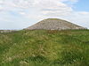
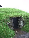
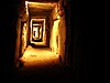
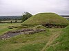
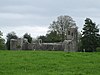
53°29′37″N 6°56′31″W / 53.493631°N 6.941964°W / 53.493631; -6.941964 410 Dowth Mound Mound, Standing Stone Dowth 53°42′13″N 6°27′01″W / 53.703650°N 6.450267°W / 53.703650; -6.450267 652 Dowth Passage Tomb Passage Tomb Dowth 53°42′14″N 6°27′02″W / 53.703841°N 6.450629°W / 53.703841; -6.450629 482 Dunmoe Castle Castle 53°40′27″N 6°38′13″W / 53.674094°N 6.636899°W / 53.674094; -6.636899 489 Church of St. Nicholas Church 53°32′11″N 6°37′03″W / 53.536281°N 6.617540°W / 53.536281; -6.617540 400 St. Seachnail's Church Church Dunshaughlin 53°30′52″N 6°32′22″W / 53.514344°N 6.539433°W / 53.514344; -6.539433 472 Fourknocks Passage Tomb Passage Tomb 53°35′48″N 6°19′35″W / 53.596739°N 6.326369°W / 53.596739; -6.326369 541 Gaulstown Barrow Round barrow Gaulstown 53°37′43″N 6°27′25″W / 53.628660°N 6.456907°W / 53.628660; -6.456907 257 Killeen Church Church 53°32′10″N 6°35′41″W / 53.536074°N 6.594700°W / 53.536074; -6.594700 409 Knowth Passage Tomb Cemetery Knowth 53°42′04″N 6°29′29″W / 53.701216°N 6.491398°W / 53.701216; -6.491398 549 Knowth Mound Enclosure & Mound Knowth 53°42′04″N 6°29′29″W / 53.701216°N 6.491398°W / 53.701216; -6.491398 543 Loughbracken Fort Mound and bailey 53°50′09″N 6°40′38″W / 53.835872°N 6.677293°W / 53.835872; -6.677293 514 Trim Castle Castle Trim 53°33′15″N 6°47′23″W / 53.554299°N 6.789731°W / 53.554299; -6.789731 651 Mountfortescue Hillfort Ringditch, Tumulus & Hillfort 53°45′43″N 6°34′34″W / 53.762048°N 6.576048°W / 53.762048; -6.576048 147.03 Newgrange Passage Tomb Newgrange 53°41′41″N 6°28′26″W / 53.694608°N 6.474026°W / 53.694608; -6.474026 110 Newtown Abbey Cathedral Newtown (Trim)
53°33′20″N 6°46′21″W / 53.555616°N 6.772612°W / 53.555616; -6.772612 551 Ninch Barrow Ninch 53°40′37″N 6°14′38″W / 53.676840°N 6.243921°W / 53.676840; -6.243921 261 Rath Meave Ritual Enclosure (Henge) ,
53°34′00″N 6°36′33″W / 53.566703°N 6.609245°W / 53.566703; -6.609245 289 Rathmore Church Church, Cross & Base 53°38′35″N 6°52′21″W / 53.643171°N 6.872439°W / 53.643171; -6.872439 495 Realtogue Fort Ringfort (Realtoge)
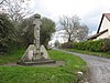
53°38′33″N 6°35′00″W / 53.642534°N 6.583406°W / 53.642534; -6.583406 322 Athcarne Cross Wayside cross (c. 1700) Gaulstown 53°37′39″N 6°26′58″W / 53.627487°N 6.449429°W / 53.627487; -6.449429 25 Robertstown Castle Castle (17th century) 53°48′06″N 6°48′33″W / 53.801668°N 6.809086°W / 53.801668; -6.809086 542 Robertstown Fort Bivallate ingfort 53°47′39″N 6°49′13″W / 53.794130°N 6.820141°W / 53.794130; -6.820141 553 Newtown Trim St. John's Priory 53°33′18″N 6°46′05″W / 53.555101°N 6.767919°W / 53.555101; -6.767919 547 Sarsfieldstown Cross Wayside cross (c. 1500) 53°39′14″N 6°15′27″W / 53.653951°N 6.257573°W / 53.653951; -6.257573 109 Skryne Church Church & Crosses Skryne 53°35′10″N 6°33′47″W / 53.586035°N 6.563158°W / 53.586035; -6.563158 666,188 Hill of Slane Church & College Slane 53°43′02″N 6°32′35″W / 53.71715°N 6.543149°W / 53.71715; -6.543149 108 St. Columb's House Church Kells 53°43′42″N 6°52′51″W / 53.728253°N 6.880766°W / 53.728253; -6.880766 158 Kells Round Tower Round Tower & High Crosses Kells 53°43′39″N 6°52′46″W / 53.727401°N 6.879579°W / 53.727401; -6.879579 679 Porch Fields Town gate & medieval roadway Trim 53°33′19″N 6°47′16″W / 53.555281°N 6.787865°W / 53.555281; -6.787865 150 Hill of Ward Earthworks 53°37′26″N 6°53′10″W / 53.624°N 6.886°W / 53.624; -6.886