From Wikipedia, the free encyclopedia
The Irish state has officially approved the following List of National Monuments in County Wicklow . In the Republic of Ireland , a structure or site may be deemed to be a "National Monument ", and therefore worthy of state protection, if it is of national importance. If the land adjoining the monument is essential to protect it, this land may also be protected.
National Monuments [ ]
NM#
Monument name
Description
Image
Townland
Location
137 Aghowle Church Church & Cross (Shillelagh
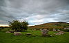
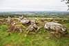
52°46′04″N 6°37′13″W / 52.767899°N 6.620402°W / 52.767899; -6.620402 416 Piper's Stones Stone Circle 53°04′19″N 6°36′46″W / 53.071899°N 6.612791°W / 53.071899; -6.612791 203 Baltinglass Abbey Abbey (Cistercian) Baltinglass 52°56′38″N 6°42′35″W / 52.943886°N 6.709747°W / 52.943886; -6.709747 418 Crossoona Rath Ringfort & Ogham Stone 52°56′39″N 6°36′51″W / 52.944262°N 6.614062°W / 52.944262; -6.614062 134 Glendalough Cathedral, Round Tower, Churches, Priory (Augustinian), Crosses, ringfort, hut site & cave Glendalough 53°00′37″N 6°19′39″W / 53.010278°N 6.3275°W / 53.010278; -6.3275 (Glendalough ) 280 St. Mark's Cross High Cross 53°09′41″N 6°32′29″W / 53.161499°N 6.54141°W / 53.161499; -6.54141 442 Castleruddery Motte Motte 52°59′34″N 6°38′40″W / 52.992817°N 6.644379°W / 52.992817; -6.644379 441 Castleruddery Stone Circle Stone Circle 52°59′28″N 6°38′12″W / 52.991092°N 6.636715°W / 52.991092; -6.636715 304 Castletimon Ogham Stone Ogham Stone52°54′16″N 6°04′13″W / 52.904307°N 6.070199°W / 52.904307; -6.070199 662 Rath Turtle Moat Ringfort 53°10′46″N 6°33′28″W / 53.179395°N 6.557808°W / 53.179395; -6.557808 449 Dwyer–McAllister Cottage House with historical associations (Donard )
52°57′44″N 6°33′53″W / 52.962126°N 6.564607°W / 52.962126; -6.564607 337 Fassaroe Cross Cross , Bray
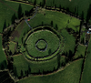
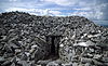
53°11′45″N 6°08′25″W / 53.195928°N 6.140404°W / 53.195928; -6.140404 267 Kilcoole Church Church Kilcoole 53°06′26″N 6°03′46″W / 53.107089°N 6.062804°W / 53.107089; -6.062804 417 Kilcroney Church Church 53°11′10″N 6°08′20″W / 53.186146°N 6.138794°W / 53.186146; -6.138794 323 Kindlestown Castle Castle 53°08′28″N 6°05′20″W / 53.141190°N 6.089022°W / 53.141190; -6.089022 419 Lemonstown Motte Motte 53°05′07″N 6°39′27″W / 53.085262°N 6.657435°W / 53.085262; -6.657435 368 Moylisha Wedge Tomb Wedge Tomb 52°45′05″N 6°37′20″W / 52.751400°N 6.622294°W / 52.751400; -6.622294 262 Raheenachluig Church Church 53°11′38″N 6°05′26″W / 53.19379°N 6.090503°W / 53.19379; -6.090503 328 Rathcoran Passage Tomb & Hillfort , ,
52°56′49″N 6°41′00″W / 52.946997°N 6.683220°W / 52.946997; -6.683220 422 Rathgall Hill Fort 52°48′08″N 6°39′47″W / 52.80224°N 6.663131°W / 52.80224; -6.663131 317 Seefin Passage Tomb Passage Tomb 53°11′10″N 6°23′42″W / 53.186168°N 6.394889°W / 53.186168; -6.394889 491 Threecastles Castle Castle Threecastles 53°10′54″N 6°29′14″W / 53.181654°N 6.487324°W / 53.181654; -6.487324 531 Tornant Moat Ringfort & Barrows 53°02′43″N 6°42′04″W / 53.045350°N 6.701020°W / 53.045350; -6.701020 135 St. Mary's Church, Downsmill Church (11th century) 53°07′47″N 6°06′38″W / 53.129729°N 6.110652°W / 53.129729; -6.110652
Sources [ ]
Categories :
National Monuments in County Wicklow Archaeological sites in County Wicklow Lists of National Monuments of Ireland County Wicklow-related lists Hidden categories:
Lists of coordinates Geographic coordinate lists Articles with Geo Use dmy dates from November 2020 Use Hiberno-English from November 2020 All Wikipedia articles written in Hiberno-English