List of State Register of Heritage Places in the Town of Claremont
The State Register of Heritage Places is maintained by the Heritage Council of Western Australia. As of 2021, 824 places are heritage-listed in the Town of Claremont,[1] of which 20 are on the State Register of Heritage Places.[2]
List[]
The Western Australian State Register of Heritage Places, as of 2021, lists the following 20 state registered places within the Town of Claremont:
| Place name | Place # | Street number | Street name | Suburb or town | Co-ordinates | Notes & former names | Photo |
|---|---|---|---|---|---|---|---|
| Claremont Teachers College (former) | 482 | 50 | Goldsworthy Road | Claremont | 31°59′14″S 115°47′17″E / 31.987167°S 115.788128°E | Edith Cowan University Claremont Campus, UWA Claremont | 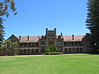
|
| Claremont Post Office | 483 | 36 | Gugeri Street | Claremont | 31°58′53″S 115°46′54″E / 31.9813°S 115.7816°E | Claremont Post Office & quarters, Dome Cafe | 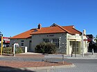
|
| Claremont Council Offices & Surroundings | 484 | 308 | Stirling Highway | Claremont | 31°59′00″S 115°46′55″E / 31.983261°S 115.781809°E | Council Offices | 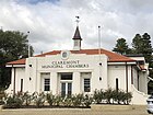
|
| Claremont Railway Station | 486 | 39 | Gugeri Street | Claremont | 31°58′51″S 115°46′53″E / 31.980706°S 115.781415°E | 
| |
| Congregational Hall & Congregational Church | 487 | 262-264 | Stirling Highway | Claremont | 31°58′57″S 115°47′06″E / 31.982589°S 115.785117°E | 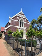
| |
| St Aidan's Uniting Church and Hall | 489 | 26 | Princess Road | Claremont | 31°59′12″S 115°47′02″E / 31.986665°S 115.783848°E | Claremont Presbyterian Church, St Aidan's Presbyterian Church | 
|
| Christ Church and Rectory, Claremont | 491 | 2 & 2A | Queenslea Drive | Claremont | 31°59′04″S 115°46′43″E / 31.984376°S 115.778509°E | 
| |
| Coronado Hotel | 492 | 206 | Stirling Highway | Claremont | 31°58′54″S 115°47′25″E / 31.981796°S 115.790167°E | Highway Hotel (former) | 
|
| Pillar Box | 495 | 256 | Stirling Highway | Claremont | 31°58′57″S 115°47′07″E / 31.982433°S 115.785307°E | Site of Halfway Tree | 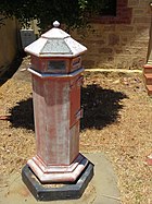
|
| Claremont Museum | 497 | 66 | Victoria Avenue | Claremont | 31°59′25″S 115°47′13″E / 31.990393°S 115.787080°E | Freshwater Bay School | 
|
| Colwyn, Claremont | 2080 | 50 & 50A | Victoria Avenue | Claremont | 31°59′23″S 115°47′06″E / 31.989709°S 115.785118°E | Colwyn | 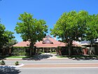
|
| Claremont School of Art Building | 4097 | 7 | Princess Road | Claremont | 31°59′10″S 115°46′57″E / 31.986166°S 115.782582°E | Former Claremont Infants School, Former State Primary School | 
|
| Claremont Primary School Precinct | 7596 | Bay View Terrace | Claremont | 31°59′11″S 115°46′56″E / 31.986259°S 115.782123°E | Freshwater Bay Primary School | 
| |
| House & Former Milk Depot | 7647 | 47 | Claremont Crescent | Swanbourne | 31°58′52″S 115°46′32″E / 31.981162°S 115.775682°E | House, 47 Claremont Crescent | 
|
| Oldham Residence, Swanbourne | 8091 | 11 | Saladin Street | Swanbourne | 31°58′53″S 115°46′13″E / 31.981376°S 115.770231°E | 11 Saladin Street, Oldham House | |
| ANZAC Cottage, Claremont | 8094 | 16 | Saunders Street | Claremont | 31°58′47″S 115°46′22″E / 31.979627°S 115.772730°E | 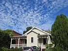
| |
| Barrett's House, Scotch College | 11977 | 76 | Shenton Road | Swanbourne | 31°58′51″S 115°46′20″E / 31.980695°S 115.772284°E | Collegiate House, Administration Building, Scotch College | 
|
| Christ Church Claremont Honour Roll | 15684 | Corner | Queenslea Drive & Stirling Highway | Claremont | 31°59′04″S 115°46′43″E / 31.984376°S 115.778509°E | 
| |
| Claremont Teachers' College War Memorial | 15686 | Goldsworthy Road | Claremont | 31°59′14″S 115°47′17″E / 31.987167°S 115.788128°E | 
| ||
| Claremont Teachers' College Roll of Honour | 15687 | Goldsworthy Road | Claremont | 31°59′14″S 115°47′17″E / 31.987167°S 115.788128°E | In entrance hall of original college building |

References[]
- ^ "Town of Claremont Heritage Places". inherit.stateheritage.wa.gov.au. Heritage Council of Western Australia. Retrieved 6 March 2021.
- ^ "Town of Claremont State Register of Heritage Places". inherit.stateheritage.wa.gov.au. Heritage Council of Western Australia. Retrieved 6 March 2021.
Categories:
- Lists of State Register of Heritage Places
- State Register of Heritage Places in the Town of Claremont