List of State Register of Heritage Places in the Shire of Carnarvon
The State Register of Heritage Places is maintained by the Heritage Council of Western Australia. As of 2021, 110 places are heritage-listed in the Shire of Carnarvon,[1] of which 14 are on the State Register of Heritage Places.[2]
List[]
The Western Australian State Register of Heritage Places, as of 2021, lists the following 14 state registered places within the Shire of Carnarvon:
| Place name | Place # | Location | Suburb or town | Co-ordinates | Built | Stateregistered | Notes | Photo |
|---|---|---|---|---|---|---|---|---|
| St George's Anglican Church | 460 | 10 Francis Street | Carnarvon | 24°53′07″S 113°39′26″E / 24.885144°S 113.657353°E | 1907 | 15 October 1999 |
|
|
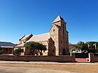
| St Mary's Star of the Sea Church | 461 | 21 Johnston Street | Carnarvon | 24°53′09″S 113°39′29″E / 24.885901°S 113.658104°E | 1910 | 17 February 2006 |
|
|
| Babbage Island Lighthouse | 462 | Annear Place, Babbage Island | Carnarvon | 24°52′33″S 113°37′51″E / 24.875941°S 113.630913°E | 1897 | 24 March 2000 |
|
|
| Site of the Gascoyne River Bridge | 463 | Carnarvon | 24°49′38″S 113°46′08″E / 24.827155°S 113.768910°E | 1931 | 15 August 2003 |
|
| |
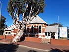
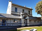
| ANZ Bank Building | 465 | 16 Robinson Street | Carnarvon | 24°53′04″S 113°39′25″E / 24.884498°S 113.656928°E | 1905 | 24 March 2000 |
|
|
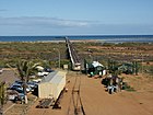
| One Mile Jetty | 467 | Babbage Island | Carnarvon | 24°52′50″S 113°37′02″E / 24.880606°S 113.617145°E | 1904 |
|
| |
| Homeswest Building | 468 | 30 Robinson Street | Carnarvon | 24°53′02″S 113°39′27″E / 24.883855°S 113.657462°E | 1929 | 07 January 2000 |
|

|
| Overseas Telecommunications Satellite Earth Station | 472 | Mahony Avenue Brown Range | 24°52′09″S 113°42′19″E / 24.869086°S 113.705155°E | 1964 | 4 May 2001 |
|

| |
| One Mile Jetty and Tramway | 4566 | Carnarvon | 24°52′50″S 113°37′02″E / 24.880606°S 113.617145°E | 1898 | 07 February 1997 | 
| ||
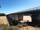
| Babbage Island Causeway Bridge | 4590 | Babbage Island Road | Carnarvon | 24°53′04″S 113°39′07″E / 24.884443°S 113.651932°E | 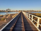
| |||
| Carnarvon Pioneer Cemetery | 4598 | Richardson Street | 24°53′35″S 113°39′36″E / 24.893054°S 113.659956°E | 1880 | 2 September 1998 |
|

| |
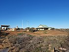
| Gascoyne Research Station | 6839 | South River Road corner Research Road | Carnarvon | 24°51′08″S 113°43′47″E / 24.852293°S 113.729840°E | 1940 | 20 April 2007 |
|
|
| Babbage Island Lighthouse | 25484 | Annear Place, Babbage Island | Carnarvon | 24°52′33″S 113°37′51″E / 24.875941°S 113.630913°E |
|

| ||
| Tramway Bridge and Tramway | 26316 | off Olivia Terrace | Carnarvon | 24°52′02″S 113°39′40″E / 24.867222°S 113.661111°E |
|

|

References[]
- ^ "Shire of Carnarvon Heritage Places". inherit.stateheritage.wa.gov.au. Heritage Council of Western Australia. Retrieved 6 March 2021.
- ^ "Shire of Carnarvon State Register of Heritage Places". inherit.stateheritage.wa.gov.au. Heritage Council of Western Australia. Retrieved 6 March 2021.
Categories:
- Lists of State Register of Heritage Places
- State Register of Heritage Places in the Shire of Carnarvon
- State Register of Heritage Places in the Gascoyne