List of State Register of Heritage Places in the Shire of Irwin
The State Register of Heritage Places is maintained by the Heritage Council of Western Australia. As of 2021, 157 places are heritage-listed in the Shire of Irwin,[1] of which 16 are on the State Register of Heritage Places.[2]
List[]
The Western Australian State Register of Heritage Places, as of 2021, lists the following 16 state registered places within the Shire of Irwin:
| Place name | Place # | Location | Suburb or town | Co-ordinates | Built | Stateregistered | Notes | Photo |
|---|---|---|---|---|---|---|---|---|
| Royal Steam Roller Flour Mill | 1210 | Waldeck Street, corner Brand Highway | Dongara | 29°14′47″S 114°55′57″E / 29.246264°S 114.932557°E | 1894 | 2 July 1993 | 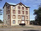
| |
| St John the Baptist Anglican Church | 1212 | 15 Waldeck Street | Dongara | 29°15′04″S 114°55′50″E / 29.251159°S 114.930578°E | 1884 | 11 December 1998 | 
| |
| The Grange | 1215 | Yardarino Road | 29°13′35″S 115°02′00″E / 29.226324°S 115.033349°E | 1850 | 20 December 2002 | |||
| Old East End | 1217 | Brand Highway, 3 km E of townsite | Dongara | 29°15′06″S 114°57′30″E / 29.251703°S 114.958256°E | 1868 | 24 November 2000 |
|
|
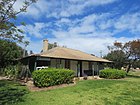
| Dr Bartlett's Residence (former) & Surrounds | 1221 | Ocean Drive | Port Denison | 29°15′14″S 114°55′38″E / 29.253846°S 114.927095°E | 1860 | 16 December 2003 |
|
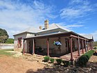
|
| Irwin Roads Board Office (former) including two Moreton Bay Fig Trees | 1227 | Point Leander Drive | Dongara | 29°15′07″S 114°56′07″E / 29.251933°S 114.935285°E | 1910 | 12 July 2002 |
|
|
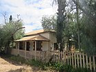
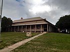
| Russ Cottage | 1230 | 260 Point Leander Drive | Port Denison | 29°15′17″S 114°56′05″E / 29.254767°S 114.934842°E | 1867 | 17 October 2003 |
|
|
| Dongara Schoolmaster's House (former) | 1233 | 22 Waldeck Street | Dongara | 29°15′02″S 114°55′52″E / 29.250501°S 114.931128°E | 1893 | 1 October 2002 |
|

|
| Dongara Uniting Church | 1234 | 12 Waldeck Street | Dongara | 29°15′06″S 114°55′52″E / 29.251625°S 114.931216°E | 1884 | 21 January 1997 |
|

|
| Dongara Police Station, Courthouse & Gaol (former) | 1235 | 3 Waldeck Street | Dongara | 29°15′09″S 114°55′50″E / 29.252446°S 114.930480°E | 1870 | 16 December 1994 |
|
|
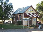
| Dongara Post Office & Quarters (former) | 1236 | 7 Waldeck Street | Dongara | 29°15′08″S 114°55′50″E / 29.252222°S 114.930606°E | 1894 | 5 November 1999 |
|

|
| Seventh Day Adventist Church (former) | 1240 | Corner Brand Highway & Bookara East Road | 29°02′55″S 114°51′07″E / 29.048645°S 114.851964°E | 1905 | 16 December 2003 | 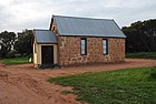
| ||
| Two Obelisks and Commemorative Plaques | 1242 | Location 592 Leander Point | Port Denison | 29°16′38″S 114°54′55″E / 29.277329°S 114.915347°E | 1896 | 24 April 2003 |
|

|
| Yardarino School (ruin) | 1245 | Short Street | 29°13′58″S 115°03′30″E / 29.232889°S 115.058257°E | 1878 | 21 January 2005 |
|

| |
| Moreton Terrace & Point Leander Drive Fig Trees | 4367 | Moreton Terrace & Point Leander Drive | Dongara | 29°15′05″S 114°55′59″E / 29.251341°S 114.932924°E | 1906 | 27 February 2004 | 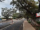
| |
| Irwin House Group | 12245 | Location 474 Midlands Road | 29°13′19″S 115°06′26″E / 29.222072°S 115.107291°E | 1850 | 20 September 2002 |
|

References[]
- ^ "Shire of Irwin Heritage Places". inherit.stateheritage.wa.gov.au. Heritage Council of Western Australia. Retrieved 12 March 2021.
- ^ "Shire of Irwin State Register of Heritage Places". inherit.stateheritage.wa.gov.au. Heritage Council of Western Australia. Retrieved 12 March 2021.
Categories:
- Lists of State Register of Heritage Places
- Shire of Irwin
- State Register of Heritage Places in the Mid West (Western Australia)