| Crossing
|
Carries
|
Location
|
Built
|
Coordinates
|
Image
|
Tolls
|
| New Jersey – New York
|
| Downtown Hudson Tubes
|
Port Authority Trans-Hudson PATH
|
Jersey City – Manhattan
|
1909
|
|
|
|
| Holland Tunnel
|
  I-78 / Route 139 I-78 / Route 139
|
1927
|
40°43′39″N 74°01′16″W / 40.72750°N 74.02111°W / 40.72750; -74.02111
|

|
$16.00 (eastbound)
|
| Uptown Hudson Tubes
|
Port Authority Trans-Hudson PATH
|
1908
|
|
|
|
| North River Tunnels
|
Amtrak and New Jersey Transit
|
North Bergen – Manhattan
|
1910
|
40°45′32″N 74°00′46″W / 40.75889°N 74.01278°W / 40.75889; -74.01278
|
|
|
| Lincoln Tunnel
|
  Route 495 / NY 495 Route 495 / NY 495
|
Weehawken – Manhattan
|
1937 (Center Tube)
1945 (North Tube)
1957 (South Tube)
|
40°45′47″N 74°00′36″W / 40.76306°N 74.01000°W / 40.76306; -74.01000
|
|
$16.00 (eastbound)
|
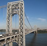
| George Washington Bridge
|
   I-95 / US 1-9 / US 46 / BR 9 I-95 / US 1-9 / US 46 / BR 9
|
Fort Lee – Manhattan
|
1931 (Upper Level)
1962 (Lower Level)
|
40°51′05″N 73°57′09″W / 40.85139°N 73.95250°W / 40.85139; -73.95250
|
|
$16.00 (eastbound)
|
| New York
|
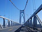
| Tappan Zee Bridge
|
   I-87 / I-287 / New York Thruway I-87 / I-287 / New York Thruway
|
South Nyack – Tarrytown
|
1955-2017 (demolished)
|
41°04′12″N 73°53′40″W / 41.07000°N 73.89444°W / 41.07000; -73.89444
|

|
|
| New Tappan Zee Bridge
|
2017 (Westbound) 2018 (Eastbound)
|
41°04′17″N 73°53′40″W / 41.07139°N 73.89444°W / 41.07139; -73.89444
|

|
$5.00 (eastbound)
|
| Bear Mountain Bridge
|
  US 6 / US 202 / Appalachian Trail / BR 9 US 6 / US 202 / Appalachian Trail / BR 9
|
Highlands – Cortlandt
|
1924
|
41°19′11″N 73°59′00″W / 41.31972°N 73.98333°W / 41.31972; -73.98333
|

|
$1.50 (eastbound)
|
| Newburgh–Beacon Bridge
|
  I-84 / NY 52 I-84 / NY 52
|
Newburgh – Beacon
|
1963 (westbound)
1980
|
41°31′11″N 73°59′50″W / 41.51972°N 73.99722°W / 41.51972; -73.99722
|

|
$1.50 (eastbound)
|
| Mid-Hudson Bridge
|
  US 44 / NY 55 US 44 / NY 55
|
Lloyd – Poughkeepsie
|
1930
|
41°42′10″N 73°56′45″W / 41.70278°N 73.94583°W / 41.70278; -73.94583
|
|
$1.50 (eastbound)
|
| Poughkeepsie Railroad Bridge
|
Former railroad bridge, now pedestrian/bicycle
|
Highland – Poughkeepsie
|
1889 (rail)
2009 (pedestrian)
|
41°42′37″N 73°56′22″W / 41.71028°N 73.93944°W / 41.71028; -73.93944
|

|
|
| Kingston-Rhinecliff Bridge
|
 NY 199 NY 199
|
Ulster – Rhinebeck
|
1957
|
41°58′38″N 73°56′43″W / 41.97722°N 73.94528°W / 41.97722; -73.94528
|

|
$1.50 (eastbound)
|
| Rip Van Winkle Bridge
|
 NY 23 NY 23
|
Catskill – Greenport
|
1935
|
42°13′24″N 73°51′01″W / 42.22333°N 73.85028°W / 42.22333; -73.85028
|
|
$1.50 (eastbound)
|
| Alfred H. Smith Memorial Bridge
|
CSX Castleton Subdivision
|
Selkirk – Castleton-on-Hudson
|
1924
|
42°30′31″N 73°46′30″W / 42.50861°N 73.77500°W / 42.50861; -73.77500
|

|
|
| Castleton Bridge
|
Berkshire Connector
|
Coeymans – Schodack
|
1959
|
42°30′33″N 73°46′24″W / 42.50917°N 73.77333°W / 42.50917; -73.77333
|

|
$1.05 (both directions, tolled as part of Thruway cost)
|
| Maiden Lane Bridge (demolished 1960s)
|
Rail
|
Albany – Rensselaer
|
1871
|
|
|
|
| Dunn Memorial Bridge
|
  US 9 / US 20 US 9 / US 20
|
1969
|
42°38′35″N 73°44′51″W / 42.64306°N 73.74750°W / 42.64306; -73.74750
|

|
| Hudson River Bridge (demolished)
|
Rail
|
|
|
|
| Livingston Avenue Bridge
|
CSX Hudson Subdivision and Amtrak
|
1901
|
42°39′16″N 73°44′30″W / 42.65444°N 73.74167°W / 42.65444; -73.74167
|

|
| Patroon Island Bridge
|
 I-90 I-90
|
1968
|
42°39′53″N 73°43′44″W / 42.66472°N 73.72889°W / 42.66472; -73.72889
|

|
| Menands Bridge
|
 NY 378 NY 378
|
Menands – Troy
|
1933
|
42°42′04″N 73°42′08″W / 42.70111°N 73.70222°W / 42.70111; -73.70222
|

|
| Congress Street Bridge
|
 NY 2 NY 2
|
Watervliet – Troy
|
N/A
|
42°43′43″N 73°41′50″W / 42.72861°N 73.69722°W / 42.72861; -73.69722
|

|
| Green Island Bridge
|
|
Green Island – Troy
|
1981
|
42°44′07″N 73°41′23″W / 42.73528°N 73.68972°W / 42.73528; -73.68972
|

|
| Collar City Bridge
|
 NY 7 NY 7
|
1981
|
42°44′25″N 73°41′18″W / 42.74028°N 73.68833°W / 42.74028; -73.68833
|

|
| 112th Street Bridge
|
 NY 470 NY 470
|
Cohoes – Troy
|
1922
1996
|
42°46′17″N 73°40′53″W / 42.77139°N 73.68139°W / 42.77139; -73.68139
|

|
| Troy-Waterford Bridge
|
 US 4 US 4
|
Waterford – Troy
|
1909
|
42°47′19″N 73°40′26″W / 42.78861°N 73.67389°W / 42.78861; -73.67389
|

|
| Albany Northern Railroad Bridge (demolished)
|
|
|
|
|
| Mechanicville Bridge
|
 NY 67 NY 67
|
Mechanicville – Schaghticoke
|
1888 (original)
1950 (replaced)
|
42°54′19″N 73°40′57″W / 42.90528°N 73.68250°W / 42.90528; -73.68250
|
|
| Rail bridge
|
Pan Am Southern Railroad
|
Stillwater – Schaghticoke
|
|
42°55′10″N 73°40′19″W / 42.91944°N 73.67194°W / 42.91944; -73.67194
|
|
| Stillwater Bridge
|
 / CR 125 / CR 125
|
Stillwater – Schaghticoke
|
1930
|
42°56′16″N 73°39′02″W / 42.93778°N 73.65056°W / 42.93778; -73.65056
|
|
| Schuylerville Bridge
|
 NY 29 NY 29
|
Schuylerville – Easton
|
|
43°05′53″N 73°34′25″W / 43.09806°N 73.57361°W / 43.09806; -73.57361
|
|
| Dix Bridge
|
  / /
|
Schuylerville – Greenwich
|
1900 (original)
2013 (pedestrian)[1]
|
43°07′00″N 73°34′53″W / 43.11667°N 73.58139°W / 43.11667; -73.58139
|
|
| Hudson Valley Railway Bridge (demolished)
|
|
Northumberland – Greenwich
|
|
43°07′13″N 73°34′50″W / 43.12028°N 73.58056°W / 43.12028; -73.58056
|
|
| Greenwich and Johnsonville Railway Bridge (demolished)
|
|
Northumberland – Greenwich
|
|
43°07′17″N 73°35′01″W / 43.12139°N 73.58361°W / 43.12139; -73.58361
|
|
| Northumberland Bridge
|
US 4
|
Northumberland – Greenwich
|
1917
|
43°07′43″N 73°35′14″W / 43.12861°N 73.58722°W / 43.12861; -73.58722
|
|
| Rail bridge
|
Canadian Pacific Rail and Amtrak
|
Moreau – Fort Edward
|
|
43°15′50″N 73°35′21″W / 43.26389°N 73.58917°W / 43.26389; -73.58917
|
|
| Bridge
|
 NY 197 NY 197
|
Moreau – Fort Edward
|
|
43°15′52″N 73°35′25″W / 43.26444°N 73.59028°W / 43.26444; -73.59028
|
|
Sandy Hill Bridge
(abandoned)
|
|
South Glens Falls – Hudson Falls
|
|
|

|
| Bridge
|

|
|
43°17′50″N 73°35′23″W / 43.29722°N 73.58972°W / 43.29722; -73.58972
|
|
| Cooper's Cave Bridge
|
 US 9 / NY 32 US 9 / NY 32
|
South Glens Falls – Glens Falls
|
2004
|
43°18′20″N 73°38′28″W / 43.30556°N 73.64111°W / 43.30556; -73.64111
|
|
| Saratoga-Warren county Bridge
|
I-87
|
Moreau – Queensbury
|
|
43°15′48″N 73°40′35″W / 43.26333°N 73.67639°W / 43.26333; -73.67639
|
|
| Irving H. Densmore Memorial Bridge[2]
|
  CR 9 / CR 16 CR 9 / CR 16
|
Corinth – Lake Luzerne
|
|
43°14′55″N 73°49′56″W / 43.24861°N 73.83222°W / 43.24861; -73.83222
|
|
| Bridge
|
 NY 9N NY 9N
|
Hadley – Lake Luzerne
|
|
43°18′17″N 73°49′58″W / 43.30472°N 73.83278°W / 43.30472; -73.83278
|
|
| County Road 44 Bridge
|
 CR 44 CR 44
|
1931[3]
|
43°19′00.9″N 73°50′32.7″W / 43.316917°N 73.842417°W / 43.316917; -73.842417
|
|
| Rail bridge (not in use)
|
Former Delaware and Hudson Railroad line
|
Thurman – Warrensburg
|
1905[4]
|
43°28′43″N 73°49′22″W / 43.47861°N 73.82278°W / 43.47861; -73.82278
|
|
| Thurman Station Bridge
|
 NY 418 NY 418
|
Thurman – Warrensburg
|
1941
|
43°28′47″N 73°49′06″W / 43.47972°N 73.81833°W / 43.47972; -73.81833
|

|
| The Glen Bridge
|
 NY 28 NY 28
|
Johnsburg – Chester
|
1959
|
43°34′57″N 73°51′36″W / 43.58250°N 73.86000°W / 43.58250; -73.86000
|

|
| Riparius Bridge
|
 NY 8 NY 8
|
Johnsburg – Chester
|
2003
|
43°39′42″N 73°53′53″W / 43.66167°N 73.89806°W / 43.66167; -73.89806
|

|
| North Creek Bridge
|
 NY 28N NY 28N
|
Johnsburg – Chester
|
1930
|
43°42′01″N 73°58′59″W / 43.70028°N 73.98306°W / 43.70028; -73.98306
|
|
| Adirondack Railway bridge
|
Saratoga and North Creek Railroad
|
|
|
43°47′51″N 74°03′05″W / 43.79750°N 74.05139°W / 43.79750; -74.05139
|
|
| Finch Pruyn Bridge
|
Pedestrian
|
Newcomb
|
1993[5]
|
43°53′40″N 74°09′51″W / 43.89444°N 74.16417°W / 43.89444; -74.16417
|
|
| Newcomb Bridge
|
NY 28N
|
Newcomb
|
|
43°57′57″N 74°07′54″W / 43.96583°N 74.13167°W / 43.96583; -74.13167
|
|
| Bridge
|
Campsite Road
|
Newcomb
|
|
43°58′08″N 74°06′57″W / 43.96889°N 74.11583°W / 43.96889; -74.11583
|
|
| Bridge
|
 CR 25 CR 25
|
Newcomb
|
|
43°57′57″N 74°03′00″W / 43.96583°N 74.05000°W / 43.96583; -74.05000
|
|
| Bridge
|
Opolescent Road
|
Newcomb
|
|
44°00′58″N 74°03′14″W / 44.01611°N 74.05389°W / 44.01611; -74.05389
|
|
| Bridge
|

|
Tahawus
|
|
44°02′37″N 74°03′29″W / 44.04361°N 74.05806°W / 44.04361; -74.05806
|
|
| Fill with culverts
|
Adirondack Park Reserve Road
|
Tahawus
|
|
44°03′04″N 74°03′45″W / 44.05111°N 74.06250°W / 44.05111; -74.06250
|
|
| Wooden foot bridge just east of Henderson Lake outlet
|
Upper Works Trail
|
Tahawus
|
|
44°05′31″N 74°03′28″W / 44.09194°N 74.05778°W / 44.09194; -74.05778
|

|


