| Crossing
|
Carries
|
Location
|
Image
|
Coordinates
|
Pennsylvania[]
|
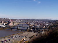
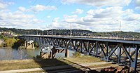
| Fort Pitt Bridge
|
 
   I-376 / US 19 Truck / US 22 / US 30 I-376 / US 19 Truck / US 22 / US 30
|
Pittsburgh
|

|
 40°26′20″N 80°00′40″W / 40.4388°N 80.0111°W / 40.4388; -80.0111 40°26′20″N 80°00′40″W / 40.4388°N 80.0111°W / 40.4388; -80.0111
|
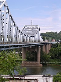
| Smithfield Street Bridge
|
Smithfield Street
|

|
40°26′06″N 80°00′07″W / 40.4351°N 80.0020°W / 40.4351; -80.0020
|
| Panhandle Bridge
|
Port Authority T Light Rail Line
|

|
40°25′59″N 79°59′53″W / 40.43306°N 79.99806°W / 40.43306; -79.99806
|
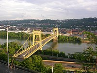
| Liberty Bridge
|
|
|
40°25′58″N 79°59′48″W / 40.4328°N 79.9968°W / 40.4328; -79.9968
|
| Philip Murray Bridge (South Tenth Street Bridge)
|
South Tenth Street
|
|
40°25′57″N 79°59′21″W / 40.43250°N 79.98917°W / 40.43250; -79.98917
|
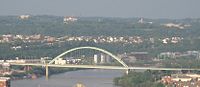
| Birmingham Bridge
|
|
|
40°26′00″N 79°58′25″W / 40.433361°N 79.973499°W / 40.433361; -79.973499
|
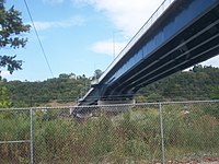
| Hot Metal Bridge
|
Hot Metal Street
|
|
Part of the Great Allegheny Passage rail/bike trail.
|
| Glenwood Bridge
|
 PA 885 PA 885
|

|
|
| Glenwood B&O Railroad Bridge
|
Allegheny Valley Railroad
|

|
|
| Homestead Grays Bridge (Homestead High Level Bridge)
|
 Blue Belt Blue Belt
|
Pittsburgh and Homestead
|

|
|
| Munhall P&LE Railroad Bridge (Pinkerton's Landing Bridge)
|
CSX Pittsburgh Subdivision
|
Rankin and Munhall
|

|
|
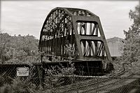
| Carrie Furnace Hot Metal Bridge (abandoned)
|
former Pennsylvania Union Railroad line
|
Rankin and Whitaker
|

|
|
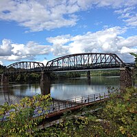
| George Rankin, Jr. Memorial Bridge (Rankin Bridge)
|
 Green Belt Green Belt
|
|
|
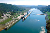
| Braddock Locks & Dam
|
|
Braddock and West Mifflin
|

|
|
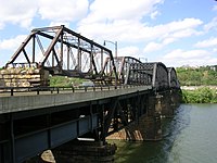
| Union Railroad Port Perry Bridge
|
Pennsylvania Union Railroad
|
North Braddock and Duquesne
|
|
40°23′17″N 79°51′08″W / 40.3880°N 79.8522°W / 40.3880; -79.8522
|
| PRR Port Perry Bridge
|
Norfolk Southern Railway Port Perry Branch
|
North Versailles Twp and Duquesne
|

|
40°23′14″N 79°51′05″W / 40.3871°N 79.8513°W / 40.3871; -79.8513
|
| McKeesport-Duquesne Bridge
|
Green Belt
|
McKeesport and Duquesne
|

|
40°21′28″N 79°50′38″W / 40.3579°N 79.8440°W / 40.3579; -79.8440
|
| McKeesport Connecting Railroad Bridge (rails removed)
|
Great Allegheny Passage bike trail
|
McKeesport and West Mifflin
|
|
40°21′25″N 79°50′51″W / 40.3569°N 79.8474°W / 40.3569; -79.8474
|
| W.D. Mansfield Memorial Bridge (Dravosburg Bridge)
|
 Yellow Belt Yellow Belt
|
McKeesport and Dravosburg
|
|
40°20′43″N 79°53′08″W / 40.3452°N 79.8856°W / 40.3452; -79.8856
|
| Senator Edward P. Zemprelli Bridge (Clairton-Glassport Bridge)
|
|
Glassport and Clairton
|

|
40°18′47″N 79°53′13″W / 40.3131°N 79.8870°W / 40.3131; -79.8870
|
| Union Railroad Clairton Bridge (Clairton Coke Works Bridge) (abandoned)
|
former Pennsylvania Union Railroad line
|
Lincoln and Clairton
|
|
40°17′40.1″N 79°52′01.3″W / 40.294472°N 79.867028°W / 40.294472; -79.867028
|
| Regis R. Malady Bridge (Elizabeth Bridge)
|
 PA 51 PA 51
|
Elizabeth and West Elizabeth
|

|
|
| Elizabeth Locks & Dam
|
|
|
|
| General Carl E. Vuono Bridge (Monongahela City Bridge)
|
 PA 136 PA 136
|
Forward Twp and Monongahela
|
|
|
| Stan Musial Bridge (Donora-Monessen Bridge)
|
C. Vance DieCas Highway
|
Monessen and Donora
|

|
| John K. Tener Memorial Bridge (Charleroi-Monessen Bridge)
|
Lock Street
|
Monessen and North Charleroi
|
|
|
| Charleroi Locks & Dam
|
|
Monessen and Charleroi
|
|
|
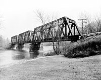
| Speers Railroad Bridge
|
Wheeling and Lake Erie Railway
|
North Belle Vernon and Speers
|

|
|
| Belle Vernon Bridge
|
 Interstate 70 Interstate 70
|

|
|
| West Brownsville Junction Bridge
|
Norfolk Southern Railway Monongahela Subdivision
|
Brownsville Twp and West Brownsville
|
|
|
| Lane Bane Bridge
|
 US 40 US 40
|
Brownsville and West Brownsville
|
|
|
| Brownsville Bridge
|
Bridge Boulevard
|
|
|
| Maxwell Lock & Dam
|
|
Luzerne Twp and Centerville
|

|
|
| Ronald C. "Smokey" Bakewell Memorial Bridge (Mon-Fayette Expressway Bridge)
|
 PA Turnpike 43 PA Turnpike 43
|
|
|
| Masontown Bridge
|
 PA 21 PA 21
|
Masontown and Monongahela Twp
|
|
|
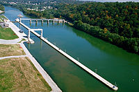
| Grays Landing Lock & Dam
|
|
Nicholson Twp and Monongahela Twp
|
|
|
| New Geneva Bridge
|
Norfolk Southern Railway Monongahela Subdivision
|

|
|
| Albert Gallatin Memorial Bridge (Point Marion Bridge)
|
 PA 88 PA 88
|
Point Marion and Dunkard Twp
|

|
|
| Point Marion Lock & Dam
|
|
Springhill Twp and Dunkard Twp
|
|
|
West Virginia[]
|
| Edith Barill Bridge (Star City Bridge)
|
 US 19 / WV 7 US 19 / WV 7
|
Star City and Granville
|

|
39°39′28″N 79°59′32″W / 39.65778°N 79.99222°W / 39.65778; -79.99222
|
|
|
US 19 (Pleasant Street)
|
Morgantown and Westover
|
|
39°37′51″N 79°57′36″W / 39.63083°N 79.96000°W / 39.63083; -79.96000
|
|
| Morgantown Lock and Dam
|
|

|
39°37′10″N 79°58′03″W / 39.61944°N 79.96750°W / 39.61944; -79.96750
|
|
|
 I-79 I-79
|
Uffington
|
|
39°35′17″N 79°58′45″W / 39.58806°N 79.97917°W / 39.58806; -79.97917
|
| Hildebrand Lock and Dam
|
|
Hilderbrand
|

|
39°34′58″N 80°00′40″W / 39.58278°N 80.01111°W / 39.58278; -80.01111
|
| Opekiska Lock and Dam
|
|
|

|
39°33′45″N 80°03′05″W / 39.56250°N 80.05139°W / 39.56250; -80.05139
|
| (abandoned)
|
former B&O Railroad line
|
Everettville
|
|
|
| Fairmont Railroad Bridge
|
CSX Fairmont Subdivision
|
Fairmont
|
|
39°30′24″N 80°07′48″W / 39.50667°N 80.13000°W / 39.50667; -80.13000
|
| Robert H. Mollohan-Jefferson St. Bridge (High Level Bridge)
|
 CR 1973 (Jefferson Street) CR 1973 (Jefferson Street)
|

|
39°28′57″N 80°08′26″W / 39.48250°N 80.14056°W / 39.48250; -80.14056
|
| David Morgan Bridge (Third Street Bridge)
|
 WV 310 (Merchant Street) WV 310 (Merchant Street)
|
|
39°28′45″N 80°08′39″W / 39.47917°N 80.14417°W / 39.47917; -80.14417
|
|
|
CSX Fairmont Subdivision
|
|
|


 Transport portal
 Engineering portal
 Pennsylvania portal