List of crossings of the Ohio River
This is a complete list of current bridges and other crossings of the Ohio River from the mouth at the Mississippi River at Cairo, Illinois to the confluence of the Allegheny and Monongahela Rivers at Pittsburgh, Pennsylvania.
Illinois–Kentucky[]


Indiana–Kentucky[]


Ohio–Kentucky[]


Ohio–West Virginia[]
| Image | Crossing | Carries | Location | Opened | Coordinates |
|---|---|---|---|---|---|

|
Norfolk Southern Bridge | Norfolk Southern Railway | South Point and Kenova | 1913 | 38°24′19″N 82°34′24″W / 38.40528°N 82.57333°W |
| West Huntington Bridge | Union Township and Huntington | 1970 | 38°24′47″N 82°29′11″W / 38.41306°N 82.48639°W | ||
| Robert C. Byrd Bridge | Chesapeake and Huntington | 1994 | 38°25′28″N 82°27′05″W / 38.42444°N 82.45139°W | ||

|
Frank Gatski Memorial Bridge | Proctorville and Huntington | 1985 | 38°26′01″N 82°23′23″W / 38.43361°N 82.38972°W | |
| Robert C. Byrd Lock and Dam | Clay Township and Gallipolis Ferry | 38°40′54″N 82°11′04″W / 38.68167°N 82.18444°W | |||

|
Silver Memorial Bridge | Addison Township and Henderson | 1969 | 38°50′04″N 82°08′51″W / 38.83444°N 82.14750°W | |
| Point Pleasant Rail Bridge | Norfolk Southern Railway | Addison Township and Point Pleasant | 38°50′46″N 82°08′29″W / 38.84611°N 82.14139°W | ||
|
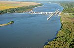
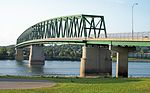
Pomeroy–Mason Bridge | Middleport and Mason | 2008 | 39°00′48″N 82°02′29″W / 39.01333°N 82.04139°W | |
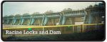
|
Racine Locks and Dam | Letart Township and Letart | |||

|
Ravenswood Bridge | Lebanon Township and Ravenswood | 1981 | ||

|
Belleville Locks and Dam | Olive Township and Belleville | |||

|
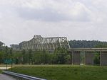
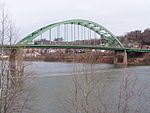
Blennerhassett Island Bridge | Belpre and Lubeck | 2008 | 39°16′36″N 81°38′49″W / 39.27667°N 81.64694°W | |
|
Parkersburg–Belpre Bridge | Belpre and Parkersburg | 1980 | ||
| Parkersburg CSX Bridge | CSX Transportation Marietta Subdivision | Belpre and Parkersburg | 1871, 1905 | ||
| Memorial Bridge | Belpre and Parkersburg | 1954 | 39°17′00″N 81°33′47″W / 39.28333°N 81.56306°W | ||
|
Williamstown Bridge | Marietta and Williamstown | 1992 | 39°24′30″N 81°26′52″W / 39.40833°N 81.44778°W | |
| Marietta–Williamstown Interstate Bridge | Marietta and Williamstown | 1967 | 39°24′11″N 81°25′52″W / 39.40306°N 81.43111°W | ||
| Willow Island Locks and Dam | Newport Township and Eureka Island | ||||

|
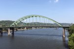
Hi Carpenter Memorial Bridge | Newport Township and St. Marys | 1973 | 39°23′16″N 81°12′51″W / 39.38778°N 81.21417°W | |
| Sistersville Ferry | Jackson Township and Sistersville | ||||

|
New Martinsville Bridge | Ohio Township and New Martinsville | 1961 | 39°39′33″N 80°51′48″W / 39.65917°N 80.86333°W | |

|
Hannibal Locks and Dam | Ohio Township and New Martinsville | 1975 | ||

|
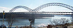
Moundsville Bridge | Mead Township and Moundsville | 1986 | 39°54′48″N 80°45′15″W / 39.91333°N 80.75417°W | |

|
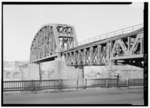
B & O Railroad Viaduct | CSX Baltimore and Ohio Railroad line | Bellaire and Benwood | 1870 | |
|
Bellaire Bridge (Closed, Demolition planned) | Bellaire and Benwood | 1926 | ||
|
Vietnam Veterans Memorial Bridge | Brookside and Wheeling | 1985 | ||

|
Wheeling Suspension Bridge (crosses main channel only) | Wheeling Island (WV) and Wheeling (crosses the main channel entirely within the state of West Virginia) | 1849 | 40°04′13″N 80°43′38″W / 40.07028°N 80.72722°W | |
|
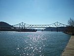
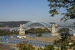
Fort Henry Bridge | Bridgeport, Wheeling Island and Wheeling | 1955 | 40°04′19″N 80°43′39″W / 40.07194°N 80.72750°W | |
| Military Order of the Purple Heart Bridge (crosses back channel only) | Bridgeport and Wheeling Island | 1998 | |||

|
Aetnaville Bridge (crosses back channel only) | Pedestrian | Martin's Ferry and Wheeling Island | 1891 | |

|
Pike Island Locks and Dam | Yorkville and Clearview | |||
| Wellsburg and Brilliant | scheduled for completion in October 2022 | 40°15′22″N 80°38′12″W / 40.25611°N 80.63667°W | |||

|
Wabash Bridge | CSX Pittsburgh and West Virginia Railway line | Mingo Junction and Follansbee | 1904 | |
| Wheeling and Lake Erie Railway | Steubenville and Coketown | 1917 | |||

|
Market Street Bridge | Steubenville and East Steubenville | 1905 | ||
| Norfolk Southern Railway | Steubenville and Weirton | ||||

|
Veterans Memorial Bridge | Steubenville and Weirton | 1990 | ||

|
Fort Steuben Bridge (demolished, 1928–2012) | Steubenville and Weirton | 40°22′47″N 80°36′48″W / 40.379824°N 80.613289°W | ||

|
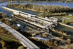
New Cumberland Locks and Dam | Knox Township and New Cumberland | |||
| Newell Bridge | East Liverpool and Newell | 1905 | |||
| Chester Bridge (1897-1970) | East Liverpool and Chester | 1897 | |||
| East Liverpool Railroad Bridge (abandoned) | Former Pittsburgh, Cincinnati, Chicago and St. Louis Railroad line | East Liverpool and Chester | |||
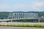
|
Jennings Randolph Bridge | East Liverpool and Chester | 1977 |
Pennsylvania[]


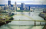
The source of the Ohio River is at the confluence of the Allegheny River and the Monongahela River (40°26′31″N 80°00′50″W / 40.44194°N 80.01389°W) at Pittsburgh, Pennsylvania.
See also[]
- List of crossings of the Allegheny River
- List of crossings of the Monongahela River
- List of crossings of the Tennessee River
- List of crossings of the Lower Mississippi River
- List of crossings of the Upper Mississippi River
References[]
- ^ West Virginia Department of Transportation: General Highway Map, Marshall County West Virginia, January 2004.
Categories:
- Crossings of the Ohio River
- Illinois transportation-related lists
- Indiana transportation-related lists
- Ohio transportation-related lists
- Lists of river crossings in the United States
- Lists of river crossings in Kentucky
- Lists of river crossings in Pennsylvania