List of impact craters in Australia

From Wikipedia, the free encyclopedia
World map in equirectangular projection of the craters on the Earth Impact Database as of November 2017 (in the SVG file, hover over a crater to show its details)
Map all coordinates using: OpenStreetMap 
Download coordinates as: KML

This list includes all 27 confirmed impact craters in Australia as listed in the Earth Impact Database.[1]

Impact craters - confirmed[]

List of impact craters in Australia is located in Australia
List of impact craters in Australia
class=notpageimage|
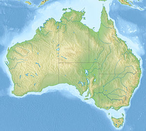
Locations of confirmed impact craters in Australia, maximum ages:
Orange mark2.svg Cenozoic
Map pointer green.svg Mesozoic
Map pointer.svg Paleozoic
Map pointer black.svg Precambrian
Name State Diameter
(km)
Age (years) Coordinates
Acraman South Australia 90 about 590 million 32°1′S 135°27′E / 32.017°S 135.450°E / -32.017; 135.450 (Acraman)
Amelia Creek Northern Territory 20 1660 - 600 million 20°55′S 134°50′E / 20.917°S 134.833°E / -20.917; 134.833 (Amelia Creek)
Boxhole Northern Territory 0.17 5,400 ± 1,500 22°37′S 135°12′E / 22.617°S 135.200°E / -22.617; 135.200 (Boxhole)
Connolly Basin Western Australia 9 < 60 million 23°32′S 124°45′E / 23.533°S 124.750°E / -23.533; 124.750 (Connolly Basin)
Crawford South Australia 8.5 > 35 million 34°43′S 139°2′E / 34.717°S 139.033°E / -34.717; 139.033 (Crawford)
Dalgaranga Western Australia 0.02 about 3000 27°38′S 117°17′E / 27.633°S 117.283°E / -27.633; 117.283 (Dalgaranga)
Flaxman South Australia 10 > 35 million 34°37′S 139°4′E / 34.617°S 139.067°E / -34.617; 139.067 (Flaxman)
Foelsche Northern Territory 6 > 545 million 16°40′S 136°47′E / 16.667°S 136.783°E / -16.667; 136.783 (Foelsche)
Glikson Western Australia 19 < 508 million 23°59′S 121°34′E / 23.983°S 121.567°E / -23.983; 121.567 (Glikson)
Goat Paddock Western Australia 5 < 50 million 18°20′S 126°40′E / 18.333°S 126.667°E / -18.333; 126.667 (Goat Paddock)
Gosses Bluff Northern Territory 22 142.5 ± 0.8 million 23°49′S 132°19′E / 23.817°S 132.317°E / -23.817; 132.317 (Gosses Bluff)
Goyder Northern Territory 3 < 1.4 billion 13°9′S 135°2′E / 13.150°S 135.033°E / -13.150; 135.033 (Goyder)
Henbury Northern Territory 0.16 4200 ± 1900 24°34′S 133°09′E / 24.567°S 133.150°E / -24.567; 133.150 (Henbury)
Kelly West Northern Territory 10 > 550 million 19°56′S 133°57′E / 19.933°S 133.950°E / -19.933; 133.950 (Kelly West)
Lawn Hill Queensland 18 > 515 million 18°40′S 138°39′E / 18.667°S 138.650°E / -18.667; 138.650 (Lawn Hill)
Liverpool Northern Territory 1.6 1000 - 543 million 12°24′S 134°3′E / ���12.400°S 134.050°E / -12.400; 134.050 (Liverpool)
Matt Wilson Northern Territory 7.5 < 1402 ± 440 million 15°30′4″S 131°10′43″E / 15.50111°S 131.17861°E / -15.50111; 131.17861 (Wilson)
Mount Toondina South Australia 4 < 110 million 27°57′S 135°22′E / 27.950°S 135.367°E / -27.950; 135.367 (Mount Toondina)
Piccaninny Western Australia 7 < 360 million 17°26′S 128°26′E / 17.433°S 128.433°E / -17.433; 128.433 (Piccaninny)
Shoemaker
(formerly Teague)
Western Australia 30 Proterozoic 25°52′S 120°53′E / 25.867°S 120.883°E / -25.867; 120.883 (Shoemaker)
Spider Western Australia 13 > 570 million 16°44′S 126°5′E / 16.733°S 126.083°E / -16.733; 126.083 (Spider)
Strangways Northern Territory 25 646 ± 42 million 15°12′S 133°35′E / 15.200°S 133.583°E / -15.200; 133.583 (Strangways)
Tookoonooka Queensland 55 128 ± 5 million 27°7′S 142°50′E / 27.117°S 142.833°E / -27.117; 142.833 (Tookoonooka)
Veevers Western Australia 0.08 < 20 thousand 22°58′S 125°22′E / 22.967°S 125.367°E / -22.967; 125.367 (Veevers)
Wolfe Creek Western Australia 0.87 300,000 19°10′S 127°48′E / 19.167°S 127.800°E / -19.167; 127.800 (Wolfe Creek)
Woodleigh Western Australia 60–120 364 ± 8 million 26°3′S 114°40′E / 26.050°S 114.667°E / -26.050; 114.667 (Woodleigh)
Yarrabubba[2] Western Australia 70 > 2 billion 27°10′S 118°50′E / 27.167°S 118.833°E / -27.167; 118.833 (Yarrabubba)
Western

Australia

5 100 million 30°38′S 121°06′E / 30.633°S 121.100°E / -30.633; 121.100 (Ora Banda)


Unconfirmed impact craters[]

The following craters are officially considered "unconfirmed" because they are not listed in the Earth Impact Database. Due to stringent requirements regarding evidence and peer-reviewed publication, newly discovered craters or those with difficulty collecting evidence generally are known for some time before becoming listed. However, entries on the unconfirmed list could still have an impact origin disproven.

Name State Diameter Age Coordinates
Bedout Indian Ocean, Western Australia 200 km 250 million 18°S 119°E / 18°S 119°E / -18; 119 (Bedout)
Darwin Crater Tasmania 1.2 km 800 thousand 42°19′S 145°40′E / 42.317°S 145.667°E / -42.317; 145.667 (Darwin crater)
Diamantina River ring feature[3] Upper Diamantina River, Queensland 130 km 300 million 22°09′S 141°54′E / 22.15°S 141.9°E / -22.15; 141.9 (?)
East Warburton Basin South Australia 200 km[4] about 300-360 million 27°0′S 140°5′E / 27.000°S 140.083°E / -27.000; 140.083 (East Warburton Basin)
South Australia 200 km[4] about 300-360 million
Hickman Crater Newman, Western Australia 0.27 km 10 - 100 thousand 23°2′13.4″S 119°40′59.3″E / 23.037056°S 119.683139°E / -23.037056; 119.683139 (Hickman Crater)
Unnamed impact[5] Cooper Basin, South Australia 80 km - 160 km 300 million (impact centre is unknown)

See also[]

Notes[]

  1. ^ Bevan, Alex. and Ken McNamara (2009) Australia's meteorite craters Welshpool, W. A. : Western Australian Museum, 2nd ed. ISBN 978-1-920843-96-0 (pbk.) and other sources provide a contrast in methodology and limitations to the information in the EID
  2. ^ Precise radiometric age establishes Yarrabubba, Western Australia, as Earth’s oldest recognised meteorite impact structure
  3. ^ "Potential asteroid impact identified in western Queensland". Geoscience Australia. Retrieved 26 June 2016.
  4. ^ a b World's largest asteroid impact zone found in Australia: Meteorite broke in two, leaving two craters each 200 km across. Mar 24, 2015
  5. ^ UQ Researcher Discovers Giant Asteroid Impact

External links[]

Retrieved from ""