List of possible impact structures on Earth
This is a list of possible impact structures on Earth. More than 130 geophysical features on the surface of the Earth have been proposed as candidate sites for impact events by appearing several times in the literature and/or being endorsed by the Impact Field Studies Group (IFSG)[1] and/or Expert Database on Earth Impact Structures (EDEIS).[2] For the purposes of this list and the List of impact craters on Earth, the terminology of "confirmed" as defined by the Earth Impact Database (EID) is considered authoritative.[3] The list below includes those features which remain unconfirmed, each of which is ranked according to a three-step confidence level as indicated by the Russian Academy of Sciences, by Anna Mikheeva:[4] 1 for "probable", 2 for "potential", and 3 for "questionable". Level 4 is given to discredited structures, which hence represent geological features other than impact craters.[4] Structures with confidence 0 are considered "confirmed" (EID) or "proven" (Mikheeva) and should be placed in the lists of confirmed craters according to continent.
List of possible impact structures[]
The following tables list geological features on Earth that some individuals have associated with impact events, but for which there is currently no confirming scientific evidence in the peer-reviewed literature. In order for a structure to be confirmed as an impact crater, it must meet a stringent set of well-established criteria. Some proposed impact structures are likely to eventually be confirmed, whereas others are likely to be shown to have been misidentified (see below). Recent extensive surveys have been done for Australian (2005),[5] African (2014),[6] and South American (2015)[7] craters, as well as those in the Arab world (2016).[8] A book review by A. Crósta and U. Reimold disputes some of the evidence presented for several of the South American structures.[9]
| Confidence[4] | 0 - proven[note 1] |
| 1 – probable | |
| 2 – potential | |
| 3 – questionable | |
| 4 – discredited | |
| Diameter | Kilometers |
| Age | Approximate |


Overview[]
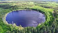
Russia's Lake Cheko is thought by one research group to be the result of the famous Tunguska event, although sediments in the lake have been dated back more than 5,000 years. There is highly speculative conjecture about the supposed Sirente impact (c. 320 ± 90 AD) having caused the Roman emperor Constantine's vision at Milvian Bridge.[323][better source needed]
The Burckle crater and Umm al Binni structure are proposed to be behind the floods that affected Sumerian civilization.[324][325] The Kachchh impact may have been witnessed by the Harappan civilization and mentioned as a fireball in Sanskrit texts.[148]
The ages of the Bloody Creek crater[326] and Hiawatha crater are uncertain.
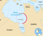
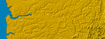
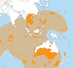
As the trend in the Earth Impact Database for about 26 confirmed craters younger than a million years old shows that almost all are less than two km (1.2 mi) in diameter (except the three km (1.9 mi) Agoudal and four km (2.5 mi) Rio Cuarto), the suggestion that two large craters, Mahuika (20 km (12 mi)) and Burckle (30 km (19 mi)), formed only within the last few millennia has been met with skepticism.[327][328][329] However, the source of the young (less than a million years old) and enormous Australasian strewnfield (c. 790 ka) is suggested to be a crater about 100 km (62 mi) across somewhere in Indochina,[330][331] with Hartung and Koeberl (1994) proposing the elongated 100 km × 35 km (62 mi × 22 mi) Tonlé Sap lake in Cambodia (visible in the map at the side) as a suspect structure.[332]
The Decorah crater has been conjectured as being part of the Ordovician meteor event.[333][better source needed]
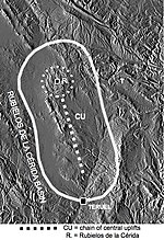
Several twin impacts have been proposed, such as the Rubielos de la Cérida and Azuara (30–40 Ma),[334] Cerro Jarau and Piratininga (c. 117 Ma),[69] and Warburton East and West (300–360 Ma).[335] However, adjacent craters may not necessarily have formed at the same time, as demonstrated by the case of the confirmed Clearwater East and West lakes.
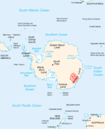
Some confirmed impacts like Sudbury or Chicxulub are also sources of magnetic anomalies[336] and/or gravity anomalies. The magnetic anomalies Bangui and Jackpine Creek,[137] the gravity anomalies Wilkes Land crater and Falkland Islands,[337] and others have been considered as being of impact origin. Bangui apparently has been discredited,[26][338] but appears again in a 2014 table of unconfirmed structures in Africa by Reimold and Koeberl.[6]
Several anomalies in Williston Basin were identified by Swatzky in the 1970s as astroblemes including Viewfield, Red Wing Creek, Eagle Butte, , and , of which only the last two are unconfirmed.[86]
The Eltanin impact has been confirmed (via an iridium anomaly and meteoritic material from ocean cores) but, as it fell into the Pacific Ocean, apparently no crater was formed. The age of Silverpit and the confirmed Boltysh crater (65.17 ± 0.64 Ma), as well as their latitude, has led to the speculative hypothesis that there may have been several impacts during the KT boundary.[339][340] Of the five oceans in descending order by area, namely the Pacific, Atlantic, Indian, Antarctic, and Arctic, only the smallest (the Arctic) does not yet have a proposed unconfirmed impact crater.
Craters larger than 100 kilometres (62 mi) in the Phanerozoic (after 541 Ma) are notable for their size as well as for the possible coeval events associated with them especially the major extinction events.
For example, the Ishim impact structure[133] is conjectured to be bounded by the late Ordivician-early Silurian (c. 445 ± 5 Ma),[134] the two Warburton basins have been linked to the Late Devonian extinction (c. 360 Ma),[305] both Bedout and the Wilkes Land crater have been associated with the severe Permian–Triassic extinction event (c. 252 Ma),[341][342] Manicouagan (c. 215 Ma) was once thought to be connected to the Triassic–Jurassic extinction event (c. 201 Ma)[343] but more recent dating has made it unlikely, while the consensus is the Chicxulub impact caused the one for Cretaceous–Paleogene (c. 66 Ma).
However, other extinction theories employ coeval periods of massive volcanism such as the Siberian Traps (Permian-Triassic) and Deccan Traps (Cretaceous-Paleogene).
Undiscovered but inferred[]
There is geological evidence for impact events having taken place on Earth on certain specific occasions, which should have formed craters, but for which no impact craters have been found. In some cases this is because of erosion and Earth's crust having been recycled through plate tectonics, in others likely because exploration of the Earth's surface is incomplete. Typically the ages are already known and the diameters can be estimated.
| Parent crater of | Expected crater diameter | Age | Notes |
|---|---|---|---|
| Dakhleh glass | 0.4 km | 150 ka | [344][345] |
| 5 km | 480 ka | [346] | |
| Australasian tektites | 32–114 km | 780 ka | [331] |
| 14 km | 820 ka | [347][348] | |
| Unknown | 60 Ma | [349] | |
| Stac Fada Member | 40 km | 1.2 Ga | [350] |
| Barberton Greenstone Belt microtektites | 500 km | 3.2 Ga | [351] |
| "hundreds of kilometers" | 3.4 Ga | [352][better source needed] |
Mistaken identity[]
Some geological processes can result in circular or near-circular features that may be mistaken for impact craters. Some examples are calderas, maars, sinkholes, glacial cirques, igneous intrusions, ring dikes, salt domes, geologic domes, ventifacts, tuff rings, forest rings, and others. Conversely, an impact crater may originally be thought as one of these geological features, like Meteor Crater (as a maar) or Upheaval Dome (as a salt dome).
The presence of shock metamorphism and shatter cones are important criteria in favor of an impact interpretation, though massive landslides (such as the Köfels landslide of 7800 BC which was once thought to be impact-related) may produce shock-like fused rocks called "frictionite".[353]
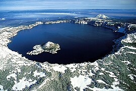
Crater Lake, Oregon (a caldera)

Three maars in Germany

Great Blue Hole, Belize (a sinkhole)
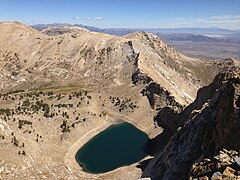
Verdi Lake (a glacial cirque)

Kondyor Massif or Konder (an igneous intrusion)[354]

Salt domes on Melville Island

Richat structure (and the similar Semsiyat)[355] as a geologic dome[356]

The Arkenu structures are now considered as a ventifact
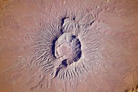
Brukkaros Mountain as a tuff ring

A forest ring from Ontario.

The Köfels landslide


See also[]
- Earth Impact Database
- Gliese 710 – example of gravitational perturbations (in mega-year scale) of the Solar System
- Impact Field Studies Group
- Impact craters
- Impact events
- List of impact craters on Earth
- List of meteor air bursts
- Tollmann's hypothetical bolide
- Traces of Catastrophe, 1998 book from Lunar and Planetary Institute – comprehensive reference on impact crater science
Notes and references[]
Notes[]
References[]
- ^ Impact Field Studies Group
- ^ Expert Database on Earth Impact Structures
- ^ "Earth Impact Database". Archived from the original on 2015-02-07. Retrieved 2016-06-02.
- ^ Jump up to: a b c d Mikheeva, 2017
- ^ Jump up to: a b Haines, P. W. (2005). "Impact cratering and distal ejecta: The Australian record". Australian Journal of Earth Sciences. 52 (4–5): 481–507. Bibcode:2005AuJES..52..481H. doi:10.1080/08120090500170351. S2CID 128705406.
- ^ Jump up to: a b c d Reimold, Wolf Uwe; Koeberl, Christian (2014). "Impact structures in Africa: A review". Journal of African Earth Sciences. 93: 57–175. Bibcode:2014JAfES..93...57R. doi:10.1016/j.jafrearsci.2014.01.008. PMC 4802546. PMID 27065753.
- ^ Acevedo, R.; Rocca, M. C.; Ponce, J.; Stinco, S. (2015). Impact Craters in South America. SpringerBriefs in Earth Sciences. Springer. ISBN 978-3-319-13092-7.
- ^ Chabou, M. C. (2016). "An updated inventory of meteorite impact structures in the Arab world". 1st ArabGU International Conference, Feb 2016, Algeria.
- ^ Crósta, Alvaro P.; Reimold, Wolf Uwe (2016). "Impact Craters in South America, by Acevedo R. D., Rocca M. C. L., Ponce J. F., and Stinco S. G. Heidelberg: Springer, 2015. 104 p. SpringerBriefs in Earth Sciences: South America and the Southern Hemisphere. ISBN 978-3-319-13092-7". Meteoritics & Planetary Science. 51 (5): 996–999. doi:10.1111/maps.12632.
- ^ List of confirmed impact craters by name - Earth Impact Database
- ^ Rampino, M.R; Volk, T. (1996). "Multiple impact event in the Paleozoic: Collision with a string of comets or asteroids?" (PDF). Geophysical Research Letters. 23 (1): 49–52. Bibcode:1996GeoRL..23...49R. doi:10.1029/95GL03605. Retrieved 2019-04-06.
- ^ Jump up to: a b c d e f g h i j k l m n Expert Database on Earth Impact Structures (EDEIS), Accessed May 2016
- ^ Murgab
- ^ Meteorite crater site of Ak-Bura
- ^ Bacharev, A (1952), The Murgab meteorite crater. Astron. Tsirk., No 122, pp. 8–10
- ^ Al Madafi
- ^ Garvin, James B.; Blodget, Herbert W. (1986). "Suspected Impact Crater Near Al Madafi, Saudi Arabia". Meteoritics. 21: 366. Bibcode:1986Metic..21..366G.
- ^ Roger Weller. Al Madafi crater
- ^ Alamo
- ^ Henry Brean (2015). New study ranks Nevada crater among world's largest, Las Vegas Review Journal
- ^ Anefis
- ^ Jump up to: a b c A. Rossi (2002). Seven Possible New Impact Structures In Western Africa Detected On Aster Imagery, Lunar and Planetary Science XXXIII
- ^ Roger Weller Anefis crater
- ^ Aorounga
- ^ Ocampo, A. C.; Pope, K. O. (1996). "Shuttle Imaging Radar (SIR-C) Images Reveal Multiple Impact Craters at Aorounga, Northern Chad". Lunar and Planetary Science. 27: 977. Bibcode:1996LPI....27..977O.
- ^ Jump up to: a b c S. Master & W. Reimold (2000). The impact cratering record of Africa: An updated inventory of proven, probable, possible, and discredited impact structures on the African continent, Catastrophic Events Conference 2000.
- ^ Arganaty
- ^ Zeilik, B. S. (1987). "The Arganaty cosmogenic crater in southern Kazakhstan and the ring structures associated with it". Akademiia Nauk SSSR, Doklady. 297 (4): 925–928. Bibcode:1987DoSSR.297..925Z.
- ^ Barash, M. (2012). "Mass Extinction of Ocean Organisms at the Paleozoic–Mesozoic Boundary: Effects and Causes". Oceanology. 52 (2): 238–248. Bibcode:2012Ocgy...52..238B. doi:10.1134/s000143701201002x. S2CID 129822484.
- ^ Unnamed ("Arlit")
- ^ David Rajmon (2010). Impact Field Studies Group
- ^ Marc Fokker (2008). Astroforum Netherlands
- ^ Azuara
- ^ Bajada del Diablo
- ^ R. D. Acevedo, J. Rabassa, M. J. Orgeira, et al. (2010) Bajada Del Diablo Impact Crater Strewn-Field, Patagonia, Argentina: The Largest Crater Field In The World? 73rd Annual Meteoritical Society Meeting
- ^ Acevedo, R.D.; Rabassa, J.; Ponce, J.F.; Martínez, O.; Orgeira, M.J.; Prezzi, C.; Corbella, H.; González-Guillot, M.; Rocca, M.; Subías, I.; Vásquez, C. (2012). "The Bajada del Diablo astrobleme-strewn field, central Patagonia Argentina: Extending the exploration to surrounding areas". Geomorphology. 169–170: 151–164. Bibcode:2012Geomo.169..151A. doi:10.1016/j.geomorph.2012.04.020.
- ^ Bajo Hondo
- ^ M. C. Rocca (2005). BAJO HONDO, CHUBUT, PATAGONIA, ARGENTINA: A NEW METEORITE IMPACT CRATER IN BASALT?, 68th Annual Meteoritical Society Meeting
- ^ Bangui
- ^ Girdler, R.; Taylor, P.; Frawley, J. (1992). "A possible impact origin for the Bangui magnetic anomaly (Central Africa)". Tectonophysics. 212 (1): 45–58. Bibcode:1992Tectp.212...45G. doi:10.1016/0040-1951(92)90139-w.
- ^ Bateke
- ^ S. Master, G.R.J. Cooper and K. Klajnik (2013). The Bateke Plateau Structure – A New Possible 7 Km Diameter Quaternary Meteorite Impact Structure In Gabon: A Remote Sensing Study, 13th SAGA Biennial Conference & Exhibition
- ^ Bedout
- ^ Becker, L.; Poreda, R. J.; Basu, A. R.; Pope, K. O.; Harrison, T. M.; Nicholson, C.; Iasky, R. (2004). "Bedout: A Possible End-Permian Impact Crater Offshore of Northwestern Australia". Science. 304 (5676): 1469–1476. Bibcode:2004Sci...304.1469B. doi:10.1126/science.1093925. PMID 15143216. S2CID 17927307.
- ^ Bee Bluff
- ^ R. A. Graham (2005) Reinvestigation of the Bee Bluff Structure South of Uvalde, Texas, 'The Uvalde Crater'. Lunar and Planetary Science XXXVI (2005)
- ^ Bee Bluff
- ^ Björkö
- ^ H. Henkel, A. Bäckström, B. Bergman, O. Stephansson, and M. Lindström (2005). Geothermal Energy from Impact Craters? The Björkö Study, Proceedings World Geothermal Congress 2005
- ^ Bloody Creek
- ^ Bohemia
- ^ Papagiannis, Michael D. (1989). "Photographs from geostationary satellites indicate the possible existence of a huge 300 KM impact crater in the Bohemian region of Czechoslovakia". Meteoritics. 24: 313. Bibcode:1989Metic..24R.313P.
- ^ Rajlich, P. (1992). "Bohemian Circular Structure, Czechoslovakia: Search for the Impact Evidence". Abstracts of Papers Presented to the International Conference on Large Meteorite Impacts and Planetary Evolution. Held August 31 – September 2, 1992, in Sudbury, Ontario, Canada. Large Meteorite Impacts and Planetary Evolution. 790. Lunar and Planetary Institute. p. 57. Bibcode:1992LPICo.790...57R. LPI Contribution 790.
- ^ Bow City
- ^ Bowers
- ^ Jump up to: a b L. P. Hrjanina (Khryanina), 2006. "Once again about Kainozoic meteorite structures in the Ross Sea, Antarctica" (PDF).
- ^ Gerard-Little, P., Abbott, D., Breger, D. and Burckle, L (2006). "Evidence for a Possible Late Pliocene Impact in the Ross Sea, Antarctica".CS1 maint: uses authors parameter (link)
- ^ Paul Rincon (2006). Space impact clue in Antarctica, BBC News
- ^ Heinrich, P.V. (2003) Possible Meteorite Impact Crater in St. Helena Parish, Louisiana Search and Discovery Article. no. 50006. American Association of Petroleum Geologist, Tulsa, Oklahoma. Retrieved March 27, 2011.
- ^ King, D.T., Jr., and Petruny, L.W.. 2007. Impact structures and craters of the U.S. Gulf coastal states. Gulf Coast Association of Geological Societies Transactions. v. 57, p. 409-425.
- ^ Matherne, C., Karunatillake, S., Hood, D.R., Duxbury, J., Herr, A., Heinrich, P., Horn, M., Webb, A. and Sivils, A., 2020. Planar Deformation Features Found Within a Possible Impact Structure, the Brushy Creek Feature, St. Helena Parish, LA. Lunar and Planetary Science Conference No. 2326, p. 2361.
- ^ Burckle
- ^ Jump up to: a b Abbott, Dallas H., Martos, Suzanne, Elkinton, Hannah, Bryant, Edward F., Gusiakov, Viacheslav, and Breger, Dee (2006). Impact craters as sources of megatsunami generated chevron dunes. 2006 Philadelphia Annual Meeting (22–25 October 2006)
- ^ Masse W. B., Bryant E., Gusiakov V., Abbott D., Rambolamanana G., Raza H., Courty M.A. (2006). Holocene Indian ocean cosmic impacts – the megatsunami chevron evidence from southern Madagascar. AGU, San Francisco
- ^ Catalina
- ^ Legg, Mark R.; Nicholson, Craig; Goldfinger, Chris; Milstein, Randall; Kamerling, Marc (2004). "Large enigmatic crater structures offshore southern California". Geophys. J. Int. 159 (2): 803–815. Bibcode:2004GeoJI.159..803L. doi:10.1111/j.1365-246x.2004.02424.x.
- ^ Brandsma Dan, Lund Steve P.; Henyey Thomas, L. (1989). "Paleomagnetism of Late Quaternary marine sediments from Santa Catalina basin, California continental borderland ". J. Geophys. Res. B. 94 (1): 547–564. Bibcode:1989JGR....94..547B. doi:10.1029/JB094iB01p00547.
- ^ Jarau
- ^ Jump up to: a b c d A. Crósta, R. Romano (2004). Brazilian Impact Craters: A Review, 35th Lunar and Planetary Science Conference
- ^ Jump up to: a b c d A. Crósta, M. Vasconcelos (2013). Update On The Current Knowledge Of The Brazilian Impact Craters, 44th Lunar and Planetary Science Conference
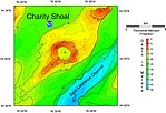
- ^ Charity Shoal
- ^ Holcombe, T.L., J. S. Warren, D. F. Reid, W. T. Virden, and D. L. Divins, 2001, Small Rimmed Depression in Lake Ontario: An Impact Crater? Journal of Great Lakes Research. vol. 27, no. 4, pp. 510–517.
- ^ Holcombe, T.L., S. Youngblut, and N. Slowey, 2013, Geological structure of Charity Shoal crater, Lake Ontario, revealed by multi beam bathymetry. Geo-Marine Letters. vol. 33, no. 4, pp. 245–252.
- ^ Suttak, P.A., 2013, High-resolution lake-based magnetic mapping and modeling of basement structures, with examples from Küçükçekmece Lagoon, Turkey and Charity Shoal, Lake Ontario. unpublished MS thesis, School of Geography and Earth Sciences, McMaster University, Hamilton, Ontario. 113 pp.
- ^ Corossol
- ^ Higgins, M.D., P. Lajeunesse, G. St-Onge, R. Sanfacon, and M. Duchesne, 2013, Impact Breccia Clast from the Corossol Crater, Canada. 76th Annual Meteoritical Society Meeting. Meteoritics and Planetary Science Supplement. id.5190.
- ^ Lajeunesse, P., St‐Onge, G., Locat, J., Duchesne, M.J., Higgins, M.D., Sanfaçon, R. and Ortiz, J., 2013. The Corossol structure: A possible impact crater on the seafloor of the northwestern Gulf of St. Lawrence, Eastern Canada. Meteoritics & Planetary Science, 48(12), pp. 2542–2558.
- ^ Lajeunesse, P., Duchesne, M.J., St-Onge, G., Locat, J., Higgins, M., Sanfaçon, R. and Ortiz, J., 2016. The Corossol Structure: a glaciated crater of possible impact origin in the northwestern Gulf of St Lawrence, eastern Canada. In Dowdeswell, J. A., Canals, M., Jakobsson, M., Todd, B. J., Dowdeswell, E. K. & Hogan, K. A. (eds) 2016. Atlas of Submarine Glacial Landforms: Modern, Quaternary and Ancient. Geological Society, London, Memoirs, 46(1), pp.127–128.
- ^ Darwin
- ^ Decorah
- ^ Briggs, D.E.; Liu, H.P.; McKay, R.M.; Witzke, B.J. (2018). "The Winneshiek biota: exceptionally well-preserved fossils in a Middle Ordovician impact crater". Journal of the Geological Society. 175 (6): 865–874. Bibcode:2018JGSoc.175..865B. doi:10.1144/jgs2018-101. S2CID 85450625.
- ^ French, B.M., McKay, R.M., Liu, H.P., Briggs, D.E. and Witzke, B.J., 2018. "The Decorah structure, northeastern Iowa: geology and evidence for formation by meteorite impact." Geological Society of America Bulletin, 130(11–12), pp. 2062–2086.
- ^ "Potential asteroid impact identified in western Queensland". Geoscience Australia. 2015-03-17. Retrieved 26 June 2016.
- ^ Glikson, A.; Korsch, R.J.; Milligan, P. (2016). "The Diamantina River ring feature, Winton region, western Queensland". Australian Journal of Earth Sciences. 63 (5): 1–11. Bibcode:2016AuJES..63..653G. doi:10.1080/08120099.2016.1220978. S2CID 132501378. Retrieved 2019-04-06.
- ^ Dumas
- ^ Jump up to: a b c Gubins, A. & Strangway, D. (1978). "Magnetic Fields Associated with a Probable Late Cretaceous Astrobleme at Dumas, Saskatchewan", Lunar and Planetary Science IX, pp. 433–435
- ^ Duolun
- ^ Wu Siben (1989). (1989). "Geologic feature of the Duolun impact crater". Lunar and Planetary Science Conference. 20: 1219. Bibcode:1989LPI....20.1219W.
- ^ El-Baz
- ^ El-Baz, F (1981). "Circular Feature Among Dunes of the Great Sand Sea, Egypt". Science. 213 (4506): 439–440. Bibcode:1981Sci...213..439E. doi:10.1126/science.213.4506.439. PMID 17760189.
- ^ Eltanin
- ^ Shuvalov V.V. (2006). Numerical modeling of the Eltanin impact: determination of projectile size and tsunami amplitude. 40 ESLAB Symposium: 1 International Conference on Impact Cratering in the Solar System, Noordwijk, 8–12 May 2006, Noordwijk: ESA, pp. 201-202
- ^ Weiss Rober, Lynett Patrick; Wunnemann Kai (2015). The Eltanin impact and its tsunami along the coast of South America: Inigshts for potential deposits Earth and Planet. Sci. Lett. Vol. 409. pp. 175–181
- ^ Faya Basin
- ^ M. Schmieder and E. Buchner (2010). The Faya Basin (Chad) revisited – structural insights from central peak morphology and potential Martian analogs, Nördlingen Ries Crater Workshop (2010).
- ^ Rocca, Maximiliano C. L.; Presser, Jaime Leonardo Báez; (2015) "A possible new very large impact structure in Falkland Islands", Historia Natural, Tercera Series, Volumen 5(2)
- ^ Rocca, Maximiliano C. L.; Rampino, Michael R.; Presser, Jaime Leonardo Báez (2017). "Geophysical evidence for a large impact structure on the Falkland Plateau". Terra Nova. 29 (4): 233–37. Bibcode:2017TeNov..29..233R. doi:10.1111/ter.12269.
- ^ Reimold, W.U.; Crósta, A.P.; Koeberl, C.; Hauser, N. (2017). "Comment on "Geophysical evidence for a large impact structure on the Falkland (Malvinas) Plateau"". Terra Nova. 29 (6): 409–410. Bibcode:2017TeNov..29..233R. doi:10.1111/ter.12284.
- ^ McCarthy, D.; Aldiss, Michael D.; Arsenikos, S.; Stone, P.; Richards, P. (2017). "Comment on "Geophysical evidence for a large impact structure on the Falkland (Malvinas) Plateau"" (PDF). Terra Nova. 29 (6): 411–415. Bibcode:2017TeNov..29..233R. doi:10.1111/ter.12285.
- ^ Acevedo, R. D.; Rocca, M. C. L.; Ponce, J.; Stinco, S. G. (2015). Impact Craters in South America. Springer. p. 23. ISBN 978-3-319-13093-4.
- ^ Fried Egg
- ^ Amos, J (2009) 'Fried Egg' may be impact crater BBC News.
- ^ Garet El Lefet
- ^ Roger Weller. Garet El Lefet crater
- ^ Jump up to: a b Classen, J. (1977). "Catalogue of 230 Certain, Probable, Possible, and Doubtful Impact Structures". Meteoritics. 12 (1): 61–78. Bibcode:1977Metic..12...61C. doi:10.1111/j.1945-5100.1977.tb00332.x.
- ^ Tornabene, L.L., 2001 The Gatun Structure: A geological assessment of a newly recognized impact structure near Lake Gatun in the Republic de Panama. Master of Science thesis. University of South Florida, Tampa, Florida, USA.
- ^ Heckadon-Moreno, S, 2013. Livio Tornabene y el meteorito de Gatun. Epocas. 28 (11):10–11.
- ^ LeBlanc, J., 2021. Stratigraphic Lexicon: The Onshore Cenozoic Sedimentary Formations of The Republic of Panama. Biosis: Biological Systems, 2(1), pp.1-173.
- ^ General San Martín
- ^ Jump up to: a b Harris, R. S.; Schultz, P. H.; Zárate, M. A. (2007) La Dulce Crater: Evidence For A 2.8 Km Impact Structure In The Eastern Pampas Of Argentina, 38th Lunar and Planetary Science Conference
- ^ R. D. Acevedo, M. Rocca, J. Rabassa and J. F. Ponce Meteorite Impact Craters In South America: A Brief Review. 74th Annual Meteoritical Society Meeting (2011)
- ^ Gnargoo
- ^ Iasky, R. P.; Glikson, A. Y. (2005). "Gnargoo: A possible 75 km-diameter post-Early Permian – pre-Cretaceous buried impact structure, Carnarvon Basin, Western Australia". Australian Journal of Earth Sciences. 52 (4–5): 575–586. Bibcode:2005AuJES..52..575I. doi:10.1080/08120090500170377. S2CID 128814897.
- ^ Monteiro, J. F. (1991). "The Guarda Circular Structure: A Possible Complex Impact Crater". Abstracts of the Lunar and Planetary Science Conference. 22: 915–916. Bibcode:1991LPI....22..915M.
- ^ Van Zalinge, M. E. (2012). "The Guarda structure, NE-Portugal: a meteorite impact crater or not?". Thesis, Utrecht University, Utrecht: 83.
- ^ Van Zalinge, M. E.; Hamers, M. F.; Drury, M. R. (2012). "The Guarda structure (Portugal): impact structure or not? Microstructural studies of quartz, zircon and monazite". Meteoritics and Planetary Science Supplement. 75: 5045–5046.
- ^ Hartney
- ^ Anderson, C. (1980). "A Seismic Reflection Study of a Probable Astrobleme near Hartney, Manitoba" (PDF). Canadian Journal of Exploration Geophysics. 16: 7.
- ^ Hiawatha
- ^ Kjær, Kurt H.; et al. (2018). "A large impact crater beneath Hiawatha Glacier in northwest Greenland". Science Advances. 4 (11): eaar8173. Bibcode:2018SciA....4.8173K. doi:10.1126/sciadv.aar8173. PMC 6235527. PMID 30443592.
- ^ Hickman
- ^ Hico
- ^ J. Glidewell (2009). SEISMIC DATA THROUGH THE HICO STRUCTURE: A POSSIBLE IMPACT FEATURE IN NORTHCENTRAL TEXAS, 40th Lunar and Planetary Science Conference
- ^ Wiberg Leanne (1982). The Hico Structure: a possible impact structure in north-central Texas, USA. Lunar and Planet. Sci. 13: Abstr. Pap. 13th Lunar and Planet. Sci. Conf., Houston, Tex., March 15–19, Pt 2., Houston, Tex., pp. 863–864
- ^ Hotchkiss
- ^ M. Mazur and R. Stewart (1998). Interpreting the Hotchkiss structure: A possible meteorite impact feature in northwestern Alberta, Consortium for Research in Elastic Wave Exploration Seismology (CREWES).
- ^ Howell
- ^ B. Deane, P. Lee, K. Milam, J. Evenick, and R.Zawislak (2004). THE HOWELL STRUCTURE, LINCOLN COUNTY, TENNESSEE: A REVIEW OF PAST AND CURRENT RESEARCH, Lunar and Planetary Science XXXV
- ^ Milam, K. A., Henderson, T., Deane, B. (2014). An Assessment Of Shock Metamorphism In Breccias From The Howell Structure, Lincoln County, Tennessee, US, Abstracts of the 2014 GSA Annual Meeting, Geological Society of America
- ^ Ibn-Batutah
- ^ Ghoneim, Eman M. (2009). "Ibn-Batutah: A possible simple impact structure in southeastern Libya, a remote sensing study". Geomorphology. 103 (3): 341–350. Bibcode:2009Geomo.103..341G. doi:10.1016/j.geomorph.2008.07.005.
- ^ Ishim
- ^ Jump up to: a b Frank Dachille (1976). (1976). "Frequency of the formation of large terrestrial impact craters". Meteoritics. 11: 270. Bibcode:1976Metic..11..270D.
- ^ Jump up to: a b Zeylik B. S.; Seytmuratova E. Yu, 1974: A meteorite-impact structure in central Kazakhstan and its magmatic-ore controlling role. Doklady Akademii Nauk SSSR: 1, pp. 167–170
- ^ Iturralde
- ^ Jackpine Creek
- ^ Jump up to: a b S. Goussev, R. Charters, J. Peirce and W. Glenn (2002). Jackpine Creek Magnetic Anomaly: A Case of the HRAM Prospect Scale Interpretation. CSEG: The Canadian Society of Exploration Geophysicists
- ^ Jalapasquillo
- ^ Maupome, L. (1974). "Possible Meteorite Crater in Mexico". Revista Mexicana de Astronomía y Astrofísica. 1: 81–. Bibcode:1974RMxAA...1...81M.
- ^ Jebel Hadid
- ^ Schmieder, Martin; Buchner, Elmar; Le Heron, Daniel Paul (2009). "The Jebel Hadid structure (Al Kufrah Basin, SE Libya) – A possible impact structure and potential hydrocarbon trap?". Marine and Petroleum Geology. 26 (3): 310–318. doi:10.1016/j.marpetgeo.2008.04.003.
- ^ Jeptha Knob
- ^ Snows Island
- ^ Talwani, Pradeep; Wildermuth, Eric; Parkinson, Chris D. (2003). "An impact crater in northeast South Carolina inferred from potential field data". Geophysical Research Letters. 30 (7): 1366. Bibcode:2003GeoRL..30.1366T. doi:10.1029/2003GL017051.
- ^ Jwaneng South
- ^ Sharad Master, Brad Pitts and Marek Wendorff (2009). Jwaneng South Structure, Botswana: a New 1.3 km Diameter Buried Cenozoic Impact Crater Discovered by Airship-mounted Gravity Gradometer, 11th SAGA Biennial Technical Meeting and Exhibition
- ^ Kachchh
- ^ Jump up to: a b R. V. Karanth, P. Thakker, and M. Gadhavi 2006. A preliminary report on the possible impact crater of Kachchh, Current Science, vol. 91, no. 7, October 2006
- ^ Kebira
- ^ Reimold, W.U.; Ch, Koeberl (2014). "Impact structures in Africa: A review". J. Afr. Earth. Sci. 93: 57–175. Bibcode:2014JAfES..93...57R. doi:10.1016/j.jafrearsci.2014.01.008. PMC 4802546. PMID 27065753.
- ^ Kilmichael
- ^ M.S. Huber, D.T. King, Jr., L.W. Petruny, and C. Koeberl (2013). REVISITING KILMICHAEL (MISSISSIPPI), A POSSIBLE IMPACT STRUCTURE, 44th Lunar and Planetary Science Conference
- ^ Robertson P.B., Butler M.D. (1982). New evidence for the impact origin of Kilmichael Mississippi. Lunar and Planet. Sci. 13: Abstr. Pap. 13th Lunar and Planet. Sci. Conf., Houston, Tex., March 15–19, 1982. Pt 2, Houston, Tex., pp. 653–654
- ^ King D.T. Petruny Jr. and L.W. (2002). COSMIC IMPACT IN THE COASTAL PLAIN OF MISSISSIPPI? THE RIDDLE THE OF THE KILMICHAEL STRUCTURE 65th Annual Meteoritical Society Meeting
- ^ Krk
- ^ T. Marjanac, A. Tomša, Lj. Marjanac, M. Calogovic & S. Fazinic (2015). Krk impact structure ejecta breccia and melt rocks on the islands of Krk and Rab, Croatian Adriatic: A clue on the impact target lithology, Bridging the Gap III (2015)
- ^ Kurai Basin
- ^ S. A. Vishnevsky (2007). The Kurai Basin, Altai mountains (Russia): First evidences of impact origin, Lunar and Planetary Science XXXVIII (2007)
- ^ La Dulce
- ^ Labynkyr
- ^ Dietz, Robert S.; McHone, John (1974). "Impact structures from ERTS imagery". Meteoritics. 9: 329. Bibcode:1974Metic...9..329D.
- ^ Roger Weller. Labynkyr ring
- ^ Lac Iro
- ^ James B. Garvin (1986). POSSIBLE IMPACT STRUCTURES IN CENTRAL AFRICA
- ^ Lairg
- ^ (in Russian) Lake Cheko
- ^ Tai Hu
- ^ Roger Weller. Tai Hu crater
- ^ Wang, K.; Geldsetzer, H. H. J. (1992). "A late Devonian impact event and its association with a possible extinction event on Eastern Gondwana". Lunar and Planetary Inst., International Conference on Large Meteorite Impacts and Planetary Evolution: 77. Bibcode:1992lmip.conf...77W.
- ^ Loch Leven
- ^ B. J. Hamill (2003). The Loch Leven Crater: Anatomy Of A Low-Angle Oblique Impact Structure, Large Meteorite Impacts
- ^ Lorne
- ^ Tonkin, P. C. (1998). "Lorne Basin, New South Wales: Evidence for a possible impact origin?". Australian Journal of Earth Sciences. 45 (5): 669–671. Bibcode:1998AuJES..45..669T. doi:10.1080/08120099808728423.
- ^ Lycksele 2
- ^ D. Nisca, H. Thunehed, L.J. Pesonen, S-Å. Elming (1997). The Lycksele structure, a huge ring formation in northern Sweden: result of an impact?, Large Meteorite Impacts and Planetary Evolution
- ^ Pesonen, L. J. (1996). "The impact cratering record of Fennoscandia". Earth, Moon, and Planets. 72 (1–3): 377–393. Bibcode:1996EM&P...72..377P. doi:10.1007/BF00117542. hdl:2060/19930000983. S2CID 125579093.
- ^ Madagascar 3
- ^ Roger Weller. Madagascar structure
- ^ Magyarmecske
- ^ Tamas Bodoky et al. (2007). Is the Magyarmecske telluric conductivity anomaly a buried impact structure?
- ^ Bodoky Tamas, Kis Marta, Kummer Istvan, Don Gyorgy (2006). The telluric conductivity anomaly at magyarmecske: is it a buried impact crater?. 40th ESLAB First International Conference on Impact Cratering in the Solar System, Noordwijk, The Netherlands
- ^ Bodoky T., Kis M., Kummer I., Don Gy. (2006). Geophysical signatures indicate a possible impact crater in Sw-Hungary. 40 ESLAB Symposium: 1 International Conference on Impact Cratering in the Solar System, Noordwijk, 8–12 May 2006, Noordwijk: ESA, p. 111
- ^ Mahuika
- ^ Abbott, D.H., A. Matzen, E.A. Bryant, and S.F. Pekar (2003). Did a bolide impact cause catastrophic tsunamis in Australia and New Zealand?. Geological Society of America Abstracts with Programs, 35:168
- ^ Maniitsoq
- ^ Garde, Adam A.; McDonald, Iain; Dyck, Brendan; Keulen, Nynke (2012). "Searching for giant, ancient impact structures on Earth: The Mesoarchaean Maniitsoq structure, West Greenland". Earth and Planetary Science Letters. 337–338: 197–210. Bibcode:2012E&PSL.337..197G. doi:10.1016/j.epsl.2012.04.026.
- ^ Scherst, Anders; Garde, Adam A. (30 July 2013). "Complete hydrothermal re-equilibration of zircon in the Maniitsoq structure, West Greenland: A 3001 Ma minimum age of impact?". Meteoritics & Planetary Science. 48 (8): 1472–1498. Bibcode:2013M&PS...48.1472S. doi:10.1111/maps.12169.
- ^ Mejaouda
- ^ Roger Weller. Mejaouda crater
- ^ Merewether crater
- ^ J. B. Garvin and J. J. Frawley (2008). Geometric Properties Of The Merewether Structure, Newfoundland, Canada.Lunar and Planetary Science XXXIX (2008)
- ^ Meseta de la Barda Negra
- ^ A.C. Ocampo, A.C. Garrido, J. Rabassa, M.C. Rocca, J.C. Echaurren, and E. Mazzoni (2005). A Possible Impact Crater In Basalt At Meseta De La Barda Negra, Neuquen, Argentina, 68th Annual Meteoritical Society Meeting
- ^ Middle Urals
- ^ G. Burba (1991). Middle-Urals Ring structure, USSR: Definition, description, possible planetary analogues, Lunar and Planetary Science conference XXII.
- ^ G. Burba (2003). The geologic evolution of the Ural Mountains: A supposed exposure to a giant impact. Microsymposium 38, MS011
- ^ Mistassini
- ^ S. Genest and F. Robert The Mistassini-Otish impact structure, Northern Quebec, Canada: an update – 1987
- ^ Mount Ashmore
- ^ Glikson, A.; Jablonski, D.; Westlake, S. (2010). "Origin of the Mt Ashmore structural dome, west Bonaparte Basin, Timor Sea". Australian Journal of Earth Sciences. 57 (4): 411–430. Bibcode:2010AuJES..57..411G. doi:10.1080/08120099.2010.481327. S2CID 129839418.
- ^ Examining a new asteroid crater found in the Timor Sea. ScienceWise 2010, Australian National Uni
- ^ Mousso
- ^ Elmar Buchner, Martin Schmieder (2007). Mousso structure: a deeply eroded, medium-sized complex impact crater in northern Chad?, Journal of African Earth Sciences 49, 71–78
- ^ Oikeyama
- ^ Sakamoto, Masao; Gucsik, Arnold; Nishido, Hirotsugu; Ninagawa, Kiyotaka; Okumura, Tasuku; Toyoda, Shin (2010), "Micro Raman spectroscopy of anomalous planar microstructures in quartz from Mt. Oikeyama: Discovery of a probable impact crater in Japan", Meteoritics and Planetary Science, 45 (1): 32, Bibcode:2010M&PS...45...32S, doi:10.1111/j.1945-5100.2009.01003.x
- ^ Mulkarra
- ^ J. B. Plescia (1999). Mulkarra Impact Structure, South Australia: A Complex Impact Structure, Lunar and Planetary Science XXX
- ^ Nastapoka
- ^ Dietz R.S., McHone J.F. (1990). Chesterfield structure (Hudson Bay): possible astrobleme. Lunar and Planet. Sci.: Abstr. Pap. 21st Lunar and Planet. Sci. Conf., March 12–16. Vol. 21, Houston (Tex.), p. 286
- ^ Brookfield Michael (2006). The great arc of eastern Hudson Bay, Canada: part of a multi-ringed impact basin. 40 ESLAB Symposium: 1 International Conference on Impact Cratering in the Solar System, Noordwijk, 8–12 May 2006, Noordwijk: ESA, p. 35
- ^ Ouro Ndia
- ^ Pantasma
- ^ Panther Mountain
- ^ Isachsen, Y.W. (1988). "Metallic spherules and a microtektite support the interpretation of a buried impact crater beneath Panther Mountain in the central Catskill Mountains, New York". 33 (4): 74. Bibcode:1998M&PSA..33R..74I. Cite journal requires
|journal=(help) - ^ Isachsen Y.W., Wright S.F., Revetta F.A., Dineen R.J. (1992). The Panther mountain circular structure, a possible buried meteorite crater. Pap. Present. Int. Conf. Large Meteorite Impacts and Planet. Evol., Sudbury, Aug. 31 – Sept. 2, 1992, Houston (Tex.), p. 40
- ^ Peerless
- ^ J.M. Comstock and J.R. Morrow (2000). PEERLESS STRUCTURE SOUTHWESTERN DANIELS COUNTY, MONTANA: A PROBABLE MIDORDOVICIAN IMPACT EVENT, Lunar and Planetary Science XXXI
- ^ Piratininga
- ^ Hachiro J. (2000). Four impact cratering on the Parana sedimentary Basin (South America). The 31st International Geological Congress, Rio de Janeiro, Aug. 6–17, 2000. Rio de Janeiro: Geol. Surv. Braz., p. 6424
- ^ Praia Grande
- ^ Ramgarh
- ^ Nayak V.K. (1997). The circular structure at Ramgarh, India: an astrobleme(?). LPI Contrib., No. 922, p. 31
- ^ Master, S.; Pandit, M.K. (1999). "New evidence for an impact origin of the Ramgarh structure, Rajasthan, India ". Meteoritics & Planetary Science. 34 (4): 79. Bibcode:1999M&PSA..34R..79M.
- ^ Ross
- ^ Berg J.H. (1991). Crustal xenoliths from Cape McCormick crater, Northern Victoria Land . 6th Int. Symp. Antarct. Earth Eci., Ranran-machi, 9–13 Sept., 1991, Abstr. - [Tokyo], p. 49
- ^ Rubielos de la Cérida
- ^ Bohor B.F., Foord E.E., Modreski P.J. (1985). Extraterrestrially-derived magnesioferrite at the K-T boundary, Caravaca, Spain. Lunar and Planet. Sci. Vol. 16: Abstr. Pap. 16th Conf., March 11–15, 1985. Pt 1, Houston, Tex., pp. 77–78
- ^ Langenhorst F., Deutsch A. (1996). The Azuara and Rubielos strictures, Spain: Twin impact craters of Alpine thrust systems? TEM investigation on deformed quartz disprove shock origin. Lunar and Planet. Sci., Vol.27, pp. 725–726
- ^ Sakhalinka
- ^ B. Levin, E. Gretskaya, G. Nemchenko (2006). A new astrobleme in the Pacific Ocean, Doklady Earth Sciences, 2006, Vol. 411, No. 8, pp. 1336–1338.
- ^ Bostwick Jennifer A., Kyte Frank T. (1993). Impact mineralogy and chemistry of the cretaceous-tertiary boundary at DSDP site 576. Lunar and Planet. Sci. Vol. 24. Abstr. Pap. 24th Lunar and Planet. Sci. Conf., March 15–19, 1993. Pt 1., Houston (Tex.), p. 157
- ^ Kyte Frank T., Bostwick Jennifer A. (1995). Magnesioferrite spinel in cretaceous/tertiary boundary sediments of the Pacific basin: remnants of hot, early ejecta from the chicxulub impact?. Earth and Planet. Sci. Lett., Vol. 132, No. 1, pp. 113–123
- ^ Kyte Frank T. (1996). A piece of the KT bolide?. Lunar and Planet. Sci. Vol. 27. Abstr. Pap. 27th Lunar and Planet. Sci. Conf., March 18–22, 1996. Pt 2, Houston (Tex.), p. 717
- ^ São Miguel do Tapuio
- ^ W. D. MacDonald, A. P. Crosta, J. Francolin (2006) Structural Dome At São Miguel do Tapuio, Piaui, Brazil, 69th Annual Meteoritical Society Meeting
- ^ Castelo Branco R.M.G. (2000). Some evidences on northeast Brazilian impact structures (astroblemes). The 31st International Geological Congress, Rio de Janeiro, Aug. 6–17, 2000, Rio de Janeiro: Geol. Surv. Braz., p. 4479
- ^ Castelo Branco R.M.G., Lopes de Castro D. (2004). Geological, geophysical and imaging data of Sao Miguel do Tapuio (SMT) astrobleme, Brazil. 67th Annual Meteoritical Society Meeting
- ^ Shanghewan
- ^ Dietz, R. S.; McHone, J. F. (1991). "Astroblemes Recently Confirmed with Shatter Cones". 54Th Annual Meeting of the Meteoritical Society. 54: 56. Bibcode:1991LPICo.766...56D.
- ^ Wu, S. (1988). "The Shanghewan Impact Crater, China". Lunar and Planetary Science Conference. 19: 1296. Bibcode:1988LPI....19.1296W.
- ^ Shiva
- ^ Shiyli
- ^ S. A. Vishnevsky (2007). Shiyli Dome, Kazakhstan: Origin Of Central Uplift By Elastic Response, Workshop on Impact Cratering II
- ^ Silverpit
- ^ Stewart SA, Allen PJ (2002). "A 20-km-diameter multi-ringed impact structure in the North Sea". Nature. 418 (6897): 520–523. Bibcode:2002Natur.418..520S. doi:10.1038/nature00914. PMID 12152076. S2CID 4381323.
- ^ Smith Kevin (2004). The North Sea Silverpit Crater: impact structure of pull-apart basin?. J. Geol. Soc., Vol. 161, No. 4, pp. 593–602
- ^ Collins G.S., Turtle E.P., Melosh H.J. (2003). Numerical simulations of silverpit crater collapse: a comparison of Tekton and SALES . LPI Contrib., No. 1155, p. 18
- ^ Stratford R. (2004). Bombarded Britain: A Search for British Impact Structures // Imperial College Press, London
- ^ Collins G., Pain C. C., Wilson C. (2006) MODELLING IMPACT CRATER COLLAPSE IN THREE DIMENSIONS
- ^ Conway Z.K., Haszeldine S., Rider M. (2006). Determining the origin of the Silverpit crater, UK southern North Sea: can you prove the existence of a meteorite crater without geochemical or mineralogical data?. 40 ESLAB Symposium: 1 International Conference on Impact Cratering in the Solar System, Noordwijk, 8–12 May 2006, Noordwijk: ESA, P. 53
- ^ Cartwright J., Davies R., Stewart S., Wall M. (2006) BURIAL OF THE SILVERPIT METEORITE CRATER
- ^ Sirente
- ^ Speranza, F.; Nicolosi, I.; Ricchetti, N.; Etiope, G.; Rochette, P.; Sagnotti, L.; De Ritis, R.; Chiappani, M. (2009). "The "Sirente crater field", Italy". J. Geophys. Res. B. 114 (3): B03103/1. doi:10.1029/2008JB005759.
- ^ Mikheeva, A.V., 2019. Sithylemenkat Lake (Sythylemenkat) USA, Alaska, The Complete Catalog of the Earth's Impact structures, ICM&MG SB RAS
- ^ Cannon, P.J. (1977). "Meteorite impact crater discovered in central Alaska with Landsat imagery". Science. 196 (4296): 1322–1324. Bibcode:1977Sci...196.1322C. doi:10.1126/science.196.4296.1322. PMID 17831748. S2CID 40015482.
- ^ Patton Jr, W.W., Miller, T.P. and Cannon, P.J., 1978. Meteorite impact crater in central Alaska. Science, 201(4352), pp. 279–279.
- ^ Rajmon, D., 2012. David Rajmon Global Impact Crater GIS Project AAPG Datapages, Tulsa Oklahoma: American Association of Petroleum Geologists.
- ^ Smerdyacheye
- ^ L. L. Kashkarov, D. D. Badjukov, A. I. Ivliev, G. V. Kalinina, and M. A. Nazarov, Vernadsky (2005). The Smerdyacheye Lake: New Evidence For Impact Origin And Formation Age, Lunar and Planetary Science XXXVI
- ^ Bayuda
- ^ A. Sparavigna (2010) Crater-Like Landform in Bayuda Desert (A Processing of Satellite Images)
- ^ A. Sparavigna Craters and ring complexes of the North-East Sudanese country
- ^ Red Sea Hills
- ^ G. Di Achille (2005). A New Candidate Impact Site In Northeastern Sudan Detected From Remote Sensing, Lunar and Planetary Science XXXVI
- ^ Chabou M.Ch. (2016). AN UPDATED INVENTORY OF METEORITE IMPACT STRUCTURES IN THE ARAB WORLD // Conference: First ArabGU International Conference (AIC-1). February 17–18, 2016. At: FSTGAT-USTHB, Algiers, ALGERIA.
- ^ Svetloyar Lake
- ^ V. Feldman, A. Kiselev (2008). Shock-melted impactites at the Svetloyar meteorite crater Volga area, Russia, Lunar and Planetary Science XXXIX
- ^ Takamatsu
- ^ Y. Miura (2007) Analyses Of Surface And Underground Data Of Takamatsu Crater In Japan. Lunar and Planetary Science XXXVIII
- ^ Miura, Y.; Okamoto, M.; Fukuchi, T.; Sato, H.; Kono, Y.; Furumoto, M. (1995). "Takamatsu Crater Structure: Preliminary Report of Impact Crater in Active Orogenic Region". Lunar and Planetary Science Conference. 26: 987. Bibcode:1995LPI....26..987M.
- ^ Miura Y. (2002). Shocked quartz materials found in Japan. 18 General Meeting of the International Mineralogical Association "Mineralogy for the New Millennium", Edingurgh, 1–6 Sept., 2002, Edinburgh: IMA, p.105
- ^ Miura Y., Hirota A. (2002). Impact-related glasses in Japan. Bull. liaison Soc. fr. mineral. et cristallogr., Vol. 14, No. 1, pp. 18–19
- ^ Tarek
- ^ Philippe Paillou et al. (2006).An extended field of crater-shaped structures in the Gilf Kebir region, Egypt: Observations and hypotheses about their origin, Journal of African Earth Sciences
- ^ Roger Weller. Tarek crater
- ^ Tatarsky North
- ^ Jump up to: a b B. W. Levin, S. A. Vishnevsky, and N. A. Palchik (2010). Underwater depressions on the bottom of the Tatarsky Strait, the Sea of Japan (western coast of the Sakhalin Island, Russia): possible marine impact craters, 41st Lunar and Planetary Science Conference
- ^ Tatarsky South
- ^ Tefé
- ^ J. de Menezes, C. de Souza, F. Fortes, and C. Filho (1999). Geophysical Evidence Of A Possible Impact Structure At The K-T Boundary Of The Solimões Basin, Brazil, 6th International Congress of the Brazilian Geophysical Society
- ^ Talundilly
- ^ K. Bron (2015) The Tookoonooka-Talundilly tsunami sequence: constraining marine impact stratigraphy, Australian School of Petroleum, The University of Adelaide
- ^ Gostin, V. A.; Therriault, A. M. (1997). "Tookoonooka, a large buried Early Cretaceous impact structure in the Eromanga Basin of southwestern Queensland, Australia". Meteoritics and Planetary Science. 32 (4): 593–599. Bibcode:1997M&PS...32..593G. doi:10.1111/j.1945-5100.1997.tb01303.x. PMID 11540422.
- ^ Temimichat
- ^ Roger Weller. Temimichat crater
- ^ Tsenkher
- ^ G. Komatsu et al. (2015)The Tsenkher structure, Gobi-Altai, Mongolia: A probable impact crater with well-preserved rampart ejecta. 46th Lunar and Planetary Science Conference (2015)
- ^ Khosbayar P., Ariunbileg Kh. (2000). Impact structure in Mongolia . The 31st International Geological Congress, Rio de Janeiro, Aug. 6–17, 2000, Rio de Janeiro: Geol. Surv. Braz, p. 6429
- ^ Toms Canyon
- ^ Glass B.P. (1987). Coesite associated with North American tektite debris in DSDP site 612 on the continental slope off NEW Jersey . Lunar and Planet. Sci. Houston (Tex.), s.a.. Vol. 18: 18th Conf., Houston Tex., March 16–20, 1987: Abstr. Pap., pp. 328–329
- ^ Poag C.Wylie, Poppe Lawrence J. (1998). The Toms Canyon structure, New Jersey outer continental shelf: A possible late Eocene impact crater . Mar. Geol., Vol. 145, No. 1, pp. 23–60
- ^ Obasi, Christian C.; Terry, Dennis O.(Jr); Myer, George H.; Grandstaff, David E. (2011). Glauconite composition and morphology, shocked quartz, and the origin of the Cretaceous(?) Main Fossiliferous Layer (MFL) in Southern New Jersey J. Sediment. Res., Vol. 81, No. 7, pp. 479–494
- ^ Master, S. and Woldai, T., 2007. Umm al Binni structure, southern Iraq, as a postulated Late Holocene meteorite impact crater. In Comet/Asteroid Impacts and Human Society (pp. 89-103). Springer, Berlin, Heidelberg.
- ^ Sissakian, V.K. and Al-Bahadily, H.A., 2018. The geological origin of the Umm Al-Binni Lake within the Ahwar of Southern Mesopotamia, Iraq. Arabian Journal of Geosciences, 11(21), pp.1-11.
- ^ Ust-Kara
- ^ C. Koeberl (1990). The Kara/Ust-Kara twin impact structure. Geological Society of America, special paper.
- ^ Vélingara
- ^ S. Wade, M. Barbieri, J. Lichtenegger (2001) The Velingara Circular Structure Esa Bulletin June 2001
- ^ Versailles
- ^ Harris, James B.; Jones, Daniel R.; Street, R. L. (1991). "A Shallow Seismic Refraction Study of the Versailles Cryptoexplosion Structure, Central Kentucky". Meteoritics. 26 (1): 47. Bibcode:1991Metic..26...47H. doi:10.1111/j.1945-5100.1991.tb01014.x.
- ^ Vichada
- ^ Victoria Island
- ^ Jump up to: a b Glikson, A.Y., Meixner, A.J., Radke, B., Uysal, I.T., Saygin, E., Vickers, J. and Mernagh, T.P., 2015. Geophysical anomalies and quartz deformation of the Warburton West structure, central Australia. Tectonophysics, 643, pp.55-72.
- ^ Jump up to: a b Glikson, A.Y. and Pirajno, F., 2018. The World’s Largest Late to Post-Archaean Asteroid Impact Structures. In Asteroids Impacts, Crustal Evolution and Related Mineral Systems with Special Reference to Australia (pp. 61-78). Springer, Cham.,
- ^ Jump up to: a b Stephen Luntz (2013). Huge Asteroid Impact Identified. Australasian Science
- ^ Glikson, A.Y., 2018. Structure and origin of Australian ring and dome features with reference to the search for asteroid impact events. Tectonophysics, 722, pp.175-196.
- ^ Dulin S. and Elmore R. D. 2008. Paleomagnetism of the Weaubleau structure, southwestern Missouri. In The sedimentary record of meteorite impacts. (pp. 55-64). Geological Society of America Special Paper No. 437.
- ^ Evans, K.R., Mickus, K.L., Rovey II, C.W. and Davis, G.H., 2003. Field Trip I: The Weaubleau-Osceola Structure: Evidence of a Mississippian Meteorite Impact in Southwestern Missouri. Association of Missouri Geologists Field Trip Guidebook. 50th Annual Meeting Springfield, Missouri September 26-27, 2003, Missouri Department of Natural Resources, Rollo, MIssouri.
- ^ Beauford, R.E., 2015. Physical records of impacts in the early and modern solar system. PhD thesis, University of Arkansas, Fayetteville, Arkansas, 174 p.
- ^ Wembo-Nyama
- ^ G. Monegato; M. Massironi & E. Martellato (2010). "The Ring Structure of Wembo-Nyama (Eastern Kasai, R.D. Congo): A Possible Impact Crater in Central Africa" (PDF). Lunar and Planetary Science. XLI (1533): 1601. Bibcode:2010LPI....41.1601M.
- ^ "Ring may be giant 'impact crater'". BBC News. 2010-03-10. Retrieved 2010-05-08.
- ^ Wilkes Land 2
- ^ Woodbury
- ^ E. F. Albin and R. S. Harris (2016). WOODBURY ASTROBLEME: FURTHER EVIDENCE FOR A LATE PROTEROZOIC IMPACT STRUCTURE IN WEST-CENTRAL GEORGIA, US, 47th Lunar and Planetary Science Conference
- ^ Yallalie
- ^ Dentith, M.; Bevan, A.; Backhouse, J.; Featherstone, W.; Koeberl, C. (1999). "Yallalie: a Buried Structure of Possible Impact Origin in the Perth Basin, Western Australia". Geological Magazine. 136 (6): 619–632. Bibcode:1999GeoM..136..619D. doi:10.1017/s0016756899003386. hdl:20.500.11937/10289.
- ^ Grant, B. The Yallalie Impact Structure.
- ^ Dodson J.R., Ramrath A. (2001). An Upper Pliocene lacustrine environmental record from south-Western Australia - preliminary results. Palaeogeogr., Palaeoclimatol., Palaeoecol., Vol. 167, No. 3, pp. 309–320
- ^ Dodson J.R., Macphail M.K. (2004). Palynological evidence for aridity events and vegetation change during the Middle Pliocene, a warm period in Southwestern Australia . Glob. and Planet. Change, Vol. 41, No. 3, pp. 285-307
- ^ Jump up to: a b Zerelia East & West
- ^ Jump up to: a b Dietrich, V. J; Lagios, E; Reusser, E; Sakkas, V; Gartzos, E; Kyriakopoulos, K (2013). "The enigmatic Zerelia twin-lakes (Thessaly, Central Greece): two potential meteorite impact Craters". Solid Earth Discussions. 5 (2): 1511–1573. Bibcode:2013SolED...5.1511D. doi:10.5194/sed-5-1511-2013. S2CID 56034694.
- ^ Whitehouse, David (2003-06-23). "Space impact 'saved Christianity'". BBC News. British Broadcasting Corporation. Retrieved 2009-09-10.
- ^ Sandra Blakeslee (2006). Ancient Crash, Epic Wave
- ^ Master, S. (2002) Umm al Binni lake, a possible Holocene impact structure in the marshes of southern Iraq. In: Leroy, S. and Stewart, I.S. (Eds.), Environmental Catastrophes and Recovery in the Holocene, Abstracts Volume, Brunel University, UK, 29 August – 2 September 2002, pp. 56–57
- ^ Stevens, G; Spooner, I; Morrow, J; Pufahl, P; Raeside, R; Grieve, RAF; Stanley, CR; Barr, SM; McMullin, D (2008). "Physical evidence of a late-glacial (Younger Dryas?) impact event in southwestern Nova Scotia". Atlantic Geology. 44: 42.
- ^ Goff, James; et al. (2010). "Analysis of the Mahuika comet impact tsunami hypothesis". Marine Geology. 271 (3/4): 292–296. Bibcode:2010MGeol.271..292G. doi:10.1016/j.margeo.2010.02.020.
- ^ Bourgeois, Joanne; Weiss, Robert (2009). "'Chevrons' are not mega-tsunami deposits – A sedimentologic assessment" (PDF). Geology. 37 (5): 403–406. Bibcode:2009Geo....37..403B. doi:10.1130/G25246A.1.
- ^ Pinter, Nicholas; Ishman, Scott E. (2008). "Impacts, mega-tsunami, and other extraordinary claims" (PDF). GSA Today. 18: 37. doi:10.1130/GSAT01801GW.1.
- ^ Povenmire H., Liu W. and Xianlin I. (1999) "Australasian tektites found in Guangxi Province, China", 30th Annual Lunar and Planetary Science Conference, Houston, March 1999.
- ^ Jump up to: a b Glass, B. P.; Pizzuto, J. E. (1994). "Geographic variation in Australasian microtektite concentrations: Implications concerning the location and size of the source crater". Journal of Geophysical Research. 99 (E9): 19075. Bibcode:1994JGR....9919075G. doi:10.1029/94JE01866.
- ^ Hartung, Jack; Koeberl, Christian (1994). "In search of the Australasian tektite source crater: The Tonle Sap hypothesis". Meteoritics. 29 (3): 411–416. Bibcode:1994Metic..29..411H. doi:10.1111/j.1945-5100.1994.tb00606.x.
- ^ Vastag, Brian (18 February 2013). "Crater found in Iowa points to asteroid break-up 470 million years ago". Washington Post. Retrieved 19 February 2013.
- ^ Ernstson, K.; Claudin, F.; Schüssler, U.; Hradil, K. (2002). "The mid-Tertiary Azuara and Rubielos de la Cérida paired impact structures (Spain)" (PDF). Treb. Mus. Geol. Barcelona. 11: 5–65.
- ^ World's largest asteroid impact zone found in Australia: Meteorite broke in two, leaving two craters each 200 km across. Mar 24, 2015
- ^ Magnetic anomaly map, Sudbury, Ontario and Quebec. Natural Resources Canada
- ^ Rocca, M.; Presser, J. (2015). "A possible new very large impact structure in Malvinas Islands". Historia Natural, Tercera Series. 5 (2).
- ^ L. Antoine, W. Reimold, and A. Tessema (1999) The Bangui Magnetic Anomaly Revisited, 62nd Annual Meteoritical Society Meeting
- ^ Howard Falcon-Lang (2010). Double space strike 'caused dinosaur extinction', BBC News
- ^ Jolley, D.; Gilmour, I.; Gurov, E.; Kelley, S.; Watson, J. (2010). "Two large meteorite impacts at the Cretaceous-Paleogene boundary". Geology. 38 (9): 835–838. Bibcode:2010Geo....38..835J. doi:10.1130/G31034.1.
- ^ Becker L., Shukolyukov A., Macassic C., Lugmair G. & Poreda R. 2006. Extraterrestrial Chromium at the Graphite Peak P/Tr boundary and in the Bedout Impact Melt Breccia. Lunar and Planetary Science XXXVII (2006), abstract # 2321.PDF
- ^ Gorder, Pam Frost (June 1, 2006). "Big Bang in Antarctica – Killer Crater Found Under Ice". Ohio State University Research News. Archived from the original on March 6, 2016.
- ^ Hodych, J.P.; G.R.Dunning (1992). "Did the Manicouagan impact trigger end-of-Triassic mass extinction?". Geology. 20 (1): 51.54. Bibcode:1992Geo....20...51H. doi:10.1130/0091-7613(1992)020<0051:DTMITE>2.3.CO;2.
- ^ Haldemann, A. F. C.; Kleindienst, M. R.; Churcher, C. S.; Smith, J. R.; Schwarcz, H. P.; Markham, K.; Osinski, G. (August 2005). "Mapping Impact Modified Sediments: Subtle Remote-Sensing Signatures of the Dakhleh Oasis Catastrophic Event, Western Desert, Egypt". Bulletin of the American Astronomical Society. 37: 648. Bibcode:2005DPS....37.1703H.
- ^ G. Osinski, A. Haldemann, et al. (2007). Impact Glass At The Dakhleh Oasis, Egypt: Evidence For A Cratering Event Or Large Aerial Burst?, Lunar and Planetary Science XXXVIII
- ^ Bland, P. A.; De Souza Filho, C. R.; Jull, A. J.; Kelley, S. P.; Hough, R. M.; Artemieva, N. A.; Pierazzo, E.; Coniglio, J.; Pinotti, L.; Evers, V.; Kearsley, A. T. (2002). "A Possible Tektite Strewn Field in the Argentinian Pampa". Science. 296 (5570): 1109–1111. Bibcode:2002Sci...296.1109B. doi:10.1126/science.1068345. PMID 12004127. S2CID 41279356.
- ^ H. Povenmire, R. S. Harris, and J. H. Cornec (2011). The New Central American Tektite and Strewn Field. 42nd Lunar and Planetary Science Conference, Houston, Texas. abstract no. 1224.
- ^ H. Povenmire, B. Burrer, J. H. Cornec, and R. S. Harris (2012). The New Central American Tektite Strewn Field Update. 43rd Lunar and Planetary Science Conference, Houston, Texas. abstract no. 1260.
- ^ Drake, Simon M.; Beard, Andrew D.; Jones, Adrian P.; Brown, David J.; Fortes, A. Dominic; Millar, Ian L.; Carter, Andrew; Baca, Jergus; Downes, Hilary (2017). "Discovery of a meteoritic ejecta layer containing unmelted impactor fragments at the base of Paleocene lavas, Isle of Skye, Scotland". Geology. 46 (2): 171. Bibcode:2018Geo....46..171D. doi:10.1130/g39452.1.
- ^ Simms, Michael J. (December 2015). "The Stac Fada impact ejecta deposit and the Lairg Gravity Low: evidence for a buried Precambrian impact crater in Scotland?". Proceedings of the Geologists' Association. 126 (6): 742–761. doi:10.1016/j.pgeola.2015.08.010. Retrieved 5 April 2017.
- ^ “Scientists reconstruct ancient impact that dwarfs dinosaur-extinction blast”, American Geophysical Union, April 9, 2014
- ^ McKirdy, Euan (18 May 2016). "This apocalyptic asteroid's impact was bigger than one that killed dinosaurs". CNN. Retrieved 19 May 2016.
- ^ Weidinger JT, Korup O (2008). "Frictionite as evidence for a large Late Quaternary rockslide near Kanchenjunga, Sikkim Himalayas, India – Implications for extreme events in mountain relief destruction". Geomorphology. 103 (1): 57–65. Bibcode:2009Geomo.103...57W. doi:10.1016/j.geomorph.2007.10.021.
- ^ Mika McKinnon (2015). This Is Not A Crater, So What Is It? at space.gizmodo.com
- ^ Roger Weller. Semsiyat crater
- ^ Dietz, R.S.; Fudali, R.; Cassidy, W. (1969). "Richat and Semsiyat Domes (Mauritania): Not Astroblemes". Geological Society of America. 80 (7): 1367–1372. Bibcode:1969GSAB...80.1367D. doi:10.1130/0016-7606(1969)80[1367:rasdmn]2.0.co;2.
Bibliography[]
- . 2019. The Complete Catalog of the Earth's Impact structures, 1. Institute of Computational Mathematics and Mathematical Geophysics SB RAS. Accessed 2019-04-02.
External links[]
- Earth Impact Database – List of confirmed earth impact sites at the Planetary and Space Science Centre, University of New Brunswick
- Impact Database (formerly Suspected Earth Impact Sites list) maintained by David Rajmon for Impact Field Studies Group, US


- Lists of impact craters on Earth
- Possible impact craters on Earth