List of mountain peaks of California

This article comprises three sortable tables of major mountain peaks[1] of the U.S. State of California.
The summit of a mountain or hill may be measured in three principal ways:
- The topographic elevation of a summit measures the height of the summit above a geodetic sea level.[2][3] The first table below ranks the 50 highest major summits of California by elevation.
- The topographic prominence of a summit is a measure of how high the summit rises above its surroundings.[4][3] The second table below ranks the 50 most prominent summits of California.
- The topographic isolation (or radius of dominance) of a summit measures how far the summit lies from its nearest point of equal elevation.[5] The third table below ranks the 50 most isolated major summits of California.
Highest major summits[]
Of the highest major summits of California, 16 peaks exceed 4000 meters (13,123 feet) elevation and 46 peaks exceed 3000 meters (9843 feet) elevation.

Most prominent summits[]
Of the most prominent summits of California, only Mount Whitney exceeds 3000 meters (9843 feet) of topographic prominence. Five peaks exceed 2000 meters (6562 feet), nine peaks are ultra-prominent summits with more than 1500 meters (4921 feet), and 35 peaks exceed 1000 meters (3281 feet) of topographic prominence.
Most isolated major summits[]
Of the most isolated major summits of California, Mount Whitney exceeds 2000 kilometers (1243 miles) of topographic isolation, Mount Shasta exceeds 500 kilometers (310.7 miles), four peaks exceed 200 kilometers (124.3 miles), and nine peaks exceed 100 kilometers (62.14 miles) of topographic isolation.
Gallery[]

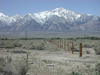
Mount Whitney is the highest summit of the Sierra Nevada, the State of California, and the contiguous United States.
Mount Williamson is the second highest mountain peak of California.
White Mountain Peak is the highest summit of the White Mountains and is the highest point within the Great Basin.

North Palisade is the highest summit of the Palisades of the Sierra Nevada.

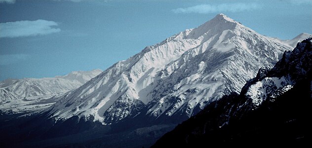
The stratovolcano Mount Shasta is the second most topographically prominent California mountain peak.

Mount Humphreys in the Sierra Nevada.

Mount Darwin is the highest summit of the Evolution Peaks of the Sierra Nevada.
Mount Tom in the Sierra Nevada.

San Gorgonio Mountain is the highest summit of the San Bernardino Mountains and the third most topographically isolated California peak.

Telescope Peak is the highest summit of the Panamint Range.

San Jacinto Peak is the highest summit of the San Jacinto Mountains.

Mount San Antonio is the highest summit of the San Gabriel Mountains.


See also[]
- List of mountain peaks of North America
- List of mountain peaks of Greenland
- List of mountain peaks of Canada
- List of mountain peaks of the Rocky Mountains
- List of mountain peaks of the United States
- List of mountain peaks of Alaska
- List of mountain peaks of Arizona
- List of mountains of California
- List of California fourteeners
- List of mountain ranges of California
- List of mountain peaks of Colorado
- List of mountain peaks of Hawaiʻi
- List of mountain peaks of Idaho
- List of mountain peaks of Montana
- List of mountain peaks of Nevada
- List of mountain peaks of New Mexico
- List of mountain peaks of Oregon
- List of mountain peaks of Utah
- List of mountain peaks of Washington (state)
- List of mountain peaks of Wyoming
- List of mountain peaks of México
- List of mountain peaks of Central America
- List of mountain peaks of the Caribbean
- California
- Geography of California
- Category:Mountains of California
- Geography of California
- Physical geography
- Topography
Notes[]
- ^ Jump up to: a b c The summit of Mount Whitney is the highest point of the Sierra Nevada, the State of California, and the contiguous United States.
- ^ Jump up to: a b c Mount Whitney is the southernmost and easternmost summit of its elevation in United States.
- ^ The elevation of Mount Williamson includes an adjustment of +1.807 m (5.93 ft) from NGVD 29 to NAVD 88.
- ^ Jump up to: a b c The summit of White Mountain Peak is the highest point of the White Mountains.
- ^ Jump up to: a b c The summit of North Palisade is the highest point of the Palisades.
- ^ Jump up to: a b c The elevation of North Palisade includes an adjustment of +1.867 m (6.13 ft) from NGVD 29 to NAVD 88.
- ^ Jump up to: a b c The summit of Mount Shasta is the highest point of the southern Cascade Range.
- ^ Jump up to: a b c The elevation of Mount Humphreys includes an adjustment of +1.842 m (6.04 ft) from NGVD 29 to NAVD 88.
- ^ The elevation of Mount Keith includes an adjustment of +1.795 m (5.89 ft) from NGVD 29 to NAVD 88.
- ^ The elevation of Mount Darwin includes an adjustment of +1.886 m (6.19 ft) from NGVD 29 to NAVD 88.
- ^ The summit of Mount Kaweah is the highest point of the Great Western Divide.
- ^ Mount Kaweah is the southernmost summit of its elevation in United States.
- ^ The elevation of Mount Kaweah includes an adjustment of +1.652 m (5.42 ft) from NGVD 29 to NAVD 88.
- ^ Jump up to: a b The elevation of Mount Gabb includes an adjustment of +1.958 m (6.42 ft) from NGVD 29 to NAVD 88.
- ^ The elevation of Mount Tom includes an adjustment of +1.379 m (4.52 ft) from NGVD 29 to NAVD 88.
- ^ The elevation of Mount Dubois includes an adjustment of +1.879 m (6.16 ft) from NGVD 29 to NAVD 88.
- ^ The elevation of Mount Pinchot includes an adjustment of +1.81 m (5.94 ft) from NGVD 29 to NAVD 88.
- ^ Jump up to: a b c The summit of Mount Ritter is the highest point of the Ritter Range.
- ^ Jump up to: a b c The elevation of Mount Ritter includes an adjustment of +1.786 m (5.86 ft) from NGVD 29 to NAVD 88.
- ^ The elevation of Red Slate Mountain includes an adjustment of +1.893 m (6.21 ft) from NGVD 29 to NAVD 88.
- ^ The elevation of Needham Mountain includes an adjustment of +1.602 m (5.26 ft) from NGVD 29 to NAVD 88.
- ^ The elevation of Twin Peaks includes an adjustment of +1.717 m (5.63 ft) from NGVD 29 to NAVD 88.
- ^ Jump up to: a b c The summit of Olancha Peak is the highest point of the southern Sierra Nevada.
- ^ The elevation of Tower Peak includes an adjustment of +1.644 m (5.39 ft) from NGVD 29 to NAVD 88.
- ^ Jump up to: a b c The summit of Mount Patterson is the highest point of the Sweetwater Mountains.
- ^ Jump up to: a b c The elevation of Mount Patterson includes an adjustment of +1.734 m (5.69 ft) from NGVD 29 to NAVD 88.
- ^ The summit elevation of San Joaquin Mountain includes a vertical offset of +0.61 m (2 ft) from the station benchmark.
- ^ Jump up to: a b c The summit of San Gorgonio Mountain is the highest point of the San Bernardino Mountains.
- ^ Jump up to: a b c The elevation of San Gorgonio Mountain includes an adjustment of +1.303 m (4.27 ft) from NGVD 29 to NAVD 88.
- ^ The elevation of Sonora Peak includes an adjustment of +1.62 m (5.31 ft) from NGVD 29 to NAVD 88.
- ^ Jump up to: a b c The summit of Waucoba Mountain is the highest point of the Inyo Mountains.
- ^ Jump up to: a b c The summit of Glass Mountain is the highest point of the Glass Mountain Ridge.
- ^ Jump up to: a b c The elevation of Keynot Peak includes an adjustment of +1.347 m (4.42 ft) from NGVD 29 to NAVD 88.
- ^ Jump up to: a b c The summit of Telescope Peak is the highest point of the Panamint Range.
- ^ The elevation of Mammoth Mountain includes an adjustment of +1.766 m (5.79 ft) from NGVD 29 to NAVD 88.
- ^ The summit elevation of Highland Peak includes a vertical offset of +0.61 m (2 ft) from the station benchmark.
- ^ Jump up to: a b c The summit of Freel Peak is the highest point of the Carson Range.
- ^ Jump up to: a b c The summit of San Jacinto Peak is the highest point of the San Jacinto Mountains.
- ^ Jump up to: a b c The summit of Mount San Antonio is the highest point of the San Gabriel Mountains.
- ^ Jump up to: a b c The elevation of Mount San Antonio includes an adjustment of +1.214 m (3.98 ft) from NGVD 29 to NAVD 88.
- ^ Jump up to: a b The elevation of Peak 9980 includes an adjustment of +1.369 m (4.49 ft) from NGVD 29 to NAVD 88.
- ^ Jump up to: a b c The summit of Eagle Peak is the highest point of the Warner Mountains.
- ^ Jump up to: a b c The summit of Mount Eddy is the highest point of the Klamath Mountains. Cite error: The named reference "X_Mount Eddy" was defined multiple times with different content (see the help page). Cite error: The named reference "X_Mount Eddy" was defined multiple times with different content (see the help page).
- ^ Jump up to: a b c The summit of Thompson Peak is the highest point of the Salmon Mountains.
- ^ Jump up to: a b c The summit of Mount Pinos is the highest point of the San Emigdio Mountains.
- ^ Jump up to: a b The summit of Mount Linn is the highest point of the . Cite error: The named reference "X_Mount Linn" was defined multiple times with different content (see the help page).
- ^ Jump up to: a b The elevation of Mount Linn includes an adjustment of +1.148 m (3.77 ft) from NGVD 29 to NAVD 88.
- ^ Jump up to: a b The summit of Junipero Serra Peak is the highest point of the Santa Lucia Range.
- ^ Jump up to: a b The elevation of Junipero Serra Peak includes an adjustment of +0.971 m (3.19 ft) from NGVD 29 to NAVD 88.
- ^ Jump up to: a b The summit of Santiago Peak is the highest point of the Santa Ana Mountains.
- ^ Jump up to: a b The summit of Clark Mountain is the highest point of the Clark Mountain Range.
- ^ Jump up to: a b The summit of Toro Peak is the highest point of the San Rosa Mountains.
- ^ Jump up to: a b The summit of Double Mountain is the highest point of the Tehachapi Mountains.
- ^ Jump up to: a b The summit of is the highest point of the Kingston Range.
- ^ Jump up to: a b The elevation of includes an adjustment of +0.902 m (2.96 ft) from NGVD 29 to NAVD 88.
- ^ Jump up to: a b The summit of Maturango Peak is the highest point of the Argus Range.
- ^ Jump up to: a b The summit elevation of Maturango Peak includes a vertical offset of +0.914 m (3 ft) from the station benchmark.
- ^ The elevation of includes an adjustment of +1.205 m (3.95 ft) from NGVD 29 to NAVD 88.
- ^ Jump up to: a b The summit of is the highest point of the Nopah Range.
- ^ Jump up to: a b The elevation of includes an adjustment of +0.791 m (2.6 ft) from NGVD 29 to NAVD 88.
- ^ Jump up to: a b The summit of San Benito Mountain is the highest point of the Diablo Range.
- ^ Jump up to: a b The summit of Loma Prieta is the highest point of the Santa Cruz Mountains.
- ^ Jump up to: a b The summit elevation of Loma Prieta includes a vertical offset of +0.305 m (1 ft) from the station benchmark.
- ^ Jump up to: a b The summit of New York Mountain is the highest point of the New York Mountains.
- ^ Jump up to: a b The elevation of New York Mountain includes an adjustment of +1.055 m (3.46 ft) from NGVD 29 to NAVD 88.
- ^ Jump up to: a b The summit of is the highest point of the Granite Mountains.
- ^ Jump up to: a b The elevation of includes an adjustment of +0.714 m (2.34 ft) from NGVD 29 to NAVD 88.
- ^ Jump up to: a b The elevation of includes an adjustment of +0.868 m (2.85 ft) from NGVD 29 to NAVD 88.
- ^ Jump up to: a b The summit of is the highest point of the Avawatz Mountains.
- ^ Jump up to: a b The summit of is the highest point of the Ord Mountains.
- ^ Jump up to: a b The elevation of includes an adjustment of +0.892 m (2.93 ft) from NGVD 29 to NAVD 88.
- ^ The elevation of Copernicus Peak includes an adjustment of +0.924 m (3.03 ft) from NGVD 29 to NAVD 88.
- ^ Jump up to: a b The summit of is the highest point of the Marble Mountains.
- ^ The elevation of Copernicus Peak includes an adjustment of +0.924 m (3.03 ft) from NGVD 29 to NAVD 88.
- ^ The summit of Mount Orizaba is the highest point of Santa Catalina Island.
- ^ The elevation of Mount Orizaba includes an adjustment of +0.728 m (2.39 ft) from NGVD 29 to NAVD 88.
- ^ The summit of is the highest point of San Clemente Island.
- ^ The summit of Mount Tamalpais West Peak is the highest point of the Marin Hills.
- ^ The elevation of Mount Tamalpais West Peak includes an adjustment of +0.833 m (2.73 ft) from NGVD 29 to NAVD 88.
- ^ The summit of Devils Peak is the highest point of Santa Cruz Island and the Channel Islands of California.
- ^ The elevation of Devils Peak includes an adjustment of +0.76 m (2.49 ft) from NGVD 29 to NAVD 88.
References[]
- ^ This article defines a significant summit as a summit with at least 100 meters (328.1 feet) of topographic prominence, and a major summit as a summit with at least 500 meters (1640 feet) of topographic prominence. All summits in this article have at least 500 meters of topographic prominence. An ultra-prominent summit is a summit with at least 1500 meters (4921 feet) of topographic prominence.
- ^ All elevations in this article include an elevation adjustment from the National Geodetic Vertical Datum of 1929 (NGVD 29) to the North American Vertical Datum of 1988 (NAVD 88). For further information, please see this United States National Geodetic Survey note.
- ^ Jump up to: a b If the elevation or prominence of a summit is calculated as a range of values, the arithmetic mean is shown.
- ^ The topographic prominence of a summit is the topographic elevation difference between the summit and its highest or key col to a higher summit. The summit may be near its key col or quite far away. The key col for Denali in Alaska is the Isthmus of Rivas in Nicaragua, 7642 kilometers (4749 miles) away.
- ^ The topographic isolation of a summit is the great-circle distance to its nearest point of equal elevation.
- ^ Jump up to: a b c "WHITNEY". Datasheet for NGS Station GT1811. U.S. National Geodetic Survey. Retrieved 8 June 2016.
- ^ Jump up to: a b c "Mount Whitney". Geographic Names Information System. United States Geological Survey.
- ^ Jump up to: a b c "Mount Whitney". Peakbagger.com. Retrieved 8 June 2016.
- ^ Jump up to: a b c "Mount Whitney". Bivouac.com. Retrieved 8 June 2016.
- ^ "Mount Williamson". Geographic Names Information System. United States Geological Survey.
- ^ "Mount Williamson". Peakbagger.com. Retrieved 8 June 2016.
- ^ "Mount Williamson". Bivouac.com. Retrieved 8 June 2016.
- ^ Jump up to: a b c "WHITE MOUNTAIN PEAK". Datasheet for NGS Station HR2559. U.S. National Geodetic Survey. Retrieved 8 June 2016.
- ^ Jump up to: a b c "White Mountain Peak". Geographic Names Information System. United States Geological Survey.
- ^ Jump up to: a b c "White Mountain Peak". Peakbagger.com. Retrieved 8 June 2016.
- ^ Jump up to: a b c "White Mountain Peak". Bivouac.com. Retrieved 8 June 2016.
- ^ Jump up to: a b c "NORTH PALISADE". Datasheet for NGS Station HR2629. U.S. National Geodetic Survey. Retrieved 8 June 2016.
- ^ Jump up to: a b c "North Palisade". Geographic Names Information System. United States Geological Survey.
- ^ Jump up to: a b c "North Palisade". Peakbagger.com. Retrieved 8 June 2016.
- ^ Jump up to: a b c "North Palisade". Bivouac.com. Retrieved 8 June 2016.
- ^ Jump up to: a b c "MT SHASTA". Datasheet for NGS Station MX1016. U.S. National Geodetic Survey. Retrieved 8 June 2016.
- ^ Jump up to: a b c "Mount Shasta". Geographic Names Information System. United States Geological Survey.
- ^ Jump up to: a b c "Mount Shasta". Peakbagger.com. Retrieved 8 June 2016.
- ^ Jump up to: a b c "Mount Shasta". Bivouac.com. Retrieved 8 June 2016.
- ^ Jump up to: a b c "MT HUMPHREYS". Datasheet for NGS Station HR2626. U.S. National Geodetic Survey. Retrieved 8 June 2016.
- ^ Jump up to: a b c "Mount Humphreys". Geographic Names Information System. United States Geological Survey.
- ^ Jump up to: a b c "Mount Humphreys". Peakbagger.com. Retrieved 8 June 2016.
- ^ Jump up to: a b c "Mount Humphreys". Bivouac.com. Retrieved 8 June 2016.
- ^ "MT KEITH". Datasheet for NGS Station GT1807. U.S. National Geodetic Survey. Retrieved 8 June 2016.
- ^ "Mount Keith". Geographic Names Information System. United States Geological Survey.
- ^ "Mount Keith". Peakbagger.com. Retrieved 8 June 2016.
- ^ "Mount Keith". Bivouac.com. Retrieved 8 June 2016.
- ^ "MT DARWIN". Datasheet for NGS Station HR2631. U.S. National Geodetic Survey. Retrieved 8 June 2016.
- ^ "Mount Darwin". Geographic Names Information System. United States Geological Survey.
- ^ "Mount Darwin". Peakbagger.com. Retrieved 8 June 2016.
- ^ "Mount Darwin". Bivouac.com. Retrieved 8 June 2016.
- ^ "Mount Kaweah". Geographic Names Information System. United States Geological Survey.
- ^ "Mount Kaweah". Peakbagger.com. Retrieved 8 June 2016.
- ^ "Mount Kaweah". Bivouac.com. Retrieved 8 June 2016.
- ^ Jump up to: a b "MORGAN". Datasheet for NGS Station HR2627. U.S. National Geodetic Survey. Retrieved 8 June 2016.
- ^ Jump up to: a b "Mount Morgan". Geographic Names Information System. United States Geological Survey.
- ^ Jump up to: a b "Mount Morgan". Peakbagger.com. Retrieved 8 June 2016.
- ^ Jump up to: a b "Mount Morgan". Bivouac.com. Retrieved 8 June 2016.
- ^ Jump up to: a b "Mount Gabb". Geographic Names Information System. United States Geological Survey.
- ^ Jump up to: a b "Mount Gabb". Peakbagger.com. Retrieved 8 June 2016.
- ^ Jump up to: a b "Mount Gabb". Bivouac.com. Retrieved 8 June 2016.
- ^ "Mount Tom". Geographic Names Information System. United States Geological Survey.
- ^ "Mount Tom". Peakbagger.com. Retrieved 8 June 2016.
- ^ "Mount Tom". Bivouac.com. Retrieved 8 June 2016.
- ^ "Mount Dubois". Geographic Names Information System. United States Geological Survey.
- ^ "Mount Dubois". Peakbagger.com. Retrieved 8 June 2016.
- ^ "Mount Dubois". Bivouac.com. Retrieved 8 June 2016.
- ^ "Mount Pinchot". Geographic Names Information System. United States Geological Survey.
- ^ "Mount Pinchot". Peakbagger.com. Retrieved 8 June 2016.
- ^ "Mount Pinchot". Bivouac.com. Retrieved 8 June 2016.
- ^ Jump up to: a b c "Mount Ritter". Geographic Names Information System. United States Geological Survey.
- ^ Jump up to: a b c "Mount Ritter". Peakbagger.com. Retrieved 8 June 2016.
- ^ Jump up to: a b c "Mount Ritter". Bivouac.com. Retrieved 8 June 2016.
- ^ "RED SLATE MOUNTAIN". Datasheet for NGS Station HR2690. U.S. National Geodetic Survey. Retrieved 8 June 2016.
- ^ "Red Slate Mountain". Geographic Names Information System. United States Geological Survey.
- ^ "Red Slate Mountain". Peakbagger.com. Retrieved 8 June 2016.
- ^ "LYELL 2". Datasheet for NGS Station HR2884. U.S. National Geodetic Survey. Retrieved 8 June 2016.
- ^ "Mount Lyell". Geographic Names Information System. United States Geological Survey.
- ^ "Mount Lyell". Peakbagger.com. Retrieved 8 June 2016.
- ^ "Mount Lyell". Bivouac.com. Retrieved 8 June 2016.
- ^ "MOUNT DANA". Datasheet for NGS Station HR2738. U.S. National Geodetic Survey. Retrieved 8 June 2016.
- ^ "Mount Dana". Geographic Names Information System. United States Geological Survey.
- ^ "Mount Dana". Peakbagger.com. Retrieved 8 June 2016.
- ^ "Mount Dana". Bivouac.com. Retrieved 8 June 2016.
- ^ Jump up to: a b "MOUNT CONNESS". Datasheet for NGS Station HR2743. U.S. National Geodetic Survey. Retrieved 8 June 2016.
- ^ Jump up to: a b "Mount Conness". Geographic Names Information System. United States Geological Survey.
- ^ Jump up to: a b "Mount Conness". Peakbagger.com. Retrieved 8 June 2016.
- ^ Jump up to: a b "Mount Conness". Bivouac.com. Retrieved 8 June 2016.
- ^ "Needham Mountain". Geographic Names Information System. United States Geological Survey.
- ^ "Needham Mountain". Peakbagger.com. Retrieved 8 June 2016.
- ^ "Needham Mountain". Bivouac.com. Retrieved 8 June 2016.
- ^ "Twin Peaks". Geographic Names Information System. United States Geological Survey.
- ^ "Twin Peaks". Peakbagger.com. Retrieved 8 June 2016.
- ^ "Twin Peaks". Bivouac.com. Retrieved 8 June 2016.
- ^ Jump up to: a b c "OLANCHA". Datasheet for NGS Station GT1820. U.S. National Geodetic Survey. Retrieved 8 June 2016.
- ^ Jump up to: a b c "Olancha Peak". Geographic Names Information System. United States Geological Survey.
- ^ Jump up to: a b c "Olancha Peak". Peakbagger.com. Retrieved 8 June 2016.
- ^ Jump up to: a b c "Olancha Peak". Bivouac.com. Retrieved 8 June 2016.
- ^ "EAGLE PEAK". Datasheet for NGS Station JR1119. U.S. National Geodetic Survey. Retrieved 8 June 2016.
- ^ "Eagle Peak". Geographic Names Information System. United States Geological Survey.
- ^ "Eagle Peak". Peakbagger.com. Retrieved 8 June 2016.
- ^ "Eagle Peak". Bivouac.com. Retrieved 8 June 2016.
- ^ "Tower Peak". Geographic Names Information System. United States Geological Survey.
- ^ "Tower Peak". Peakbagger.com. Retrieved 8 June 2016.
- ^ "Tower Peak". Bivouac.com. Retrieved 8 June 2016.
- ^ Jump up to: a b c "Mount Patterson". Geographic Names Information System. United States Geological Survey.
- ^ Jump up to: a b c "Mount Patterson". Peakbagger.com. Retrieved 8 June 2016.
- ^ Jump up to: a b c "Mount Patterson". Bivouac.com. Retrieved 8 June 2016.
- ^ "SAN JOAQUIN". Datasheet for NGS Station HR2890. U.S. National Geodetic Survey. Retrieved 8 June 2016.
- ^ "San Joaquin Mountain". Geographic Names Information System. United States Geological Survey.
- ^ "San Joaquin Mountain". Peakbagger.com. Retrieved 8 June 2016.
- ^ "San Joaquin Mountain". Bivouac.com. Retrieved 8 June 2016.
- ^ "LEAVITT". Datasheet for NGS Station JR1124. U.S. National Geodetic Survey. Retrieved 8 June 2016.
- ^ "Leavitt Peak". Geographic Names Information System. United States Geological Survey.
- ^ "Leavitt Peak". Peakbagger.com. Retrieved 8 June 2016.
- ^ "Leavitt Peak". Bivouac.com. Retrieved 8 June 2016.
- ^ Jump up to: a b "KERN". Datasheet for NGS Station GT1831. U.S. National Geodetic Survey. Retrieved 8 June 2016.
- ^ Jump up to: a b "Kern Peak". Geographic Names Information System. United States Geological Survey.
- ^ Jump up to: a b "Kern Peak". Peakbagger.com. Retrieved 8 June 2016.
- ^ Jump up to: a b "Kern Peak". Bivouac.com. Retrieved 8 June 2016.
- ^ Jump up to: a b c "San Gorgonio Mountain". Geographic Names Information System. United States Geological Survey.
- ^ Jump up to: a b c "San Gorgonio Mountain". Peakbagger.com. Retrieved 8 June 2016.
- ^ Jump up to: a b c "San Gorgonio Mountain". Bivouac.com. Retrieved 8 June 2016.
- ^ "Sonora Peak". Geographic Names Information System. United States Geological Survey.
- ^ "Sonora Peak". Peakbagger.com. Retrieved 8 June 2016.
- ^ "Sonora Peak". Bivouac.com. Retrieved 8 June 2016.
- ^ Jump up to: a b c "WAUCOBA". Datasheet for NGS Station HR2612. U.S. National Geodetic Survey. Retrieved 8 June 2016.
- ^ Jump up to: a b c "Waucoba Mountain". Geographic Names Information System. United States Geological Survey.
- ^ Jump up to: a b c "Waucoba Mountain". Peakbagger.com. Retrieved 8 June 2016.
- ^ Jump up to: a b c "Waucoba Mountain". Bivouac.com. Retrieved 8 June 2016.
- ^ Jump up to: a b c "GLASS MOUNTAIN". Datasheet for NGS Station HR2673. U.S. National Geodetic Survey. Retrieved 8 June 2016.
- ^ Jump up to: a b c "Glass Mountain". Geographic Names Information System. United States Geological Survey.
- ^ Jump up to: a b c "Glass Mountain". Peakbagger.com. Retrieved 8 June 2016.
- ^ Jump up to: a b c "Glass Mountain". Bivouac.com. Retrieved 8 June 2016.
- ^ Jump up to: a b c "Keynot Peak". Geographic Names Information System. United States Geological Survey.
- ^ Jump up to: a b c "Keynot Peak". Peakbagger.com. Retrieved 8 June 2016.
- ^ Jump up to: a b c "Keynot Peak". Bivouac.com. Retrieved 8 June 2016.
- ^ Jump up to: a b c "TELESCOPE". Datasheet for NGS Station GS0799. U.S. National Geodetic Survey. Retrieved 8 June 2016.
- ^ Jump up to: a b c "Telescope Peak". Geographic Names Information System. United States Geological Survey.
- ^ Jump up to: a b c "Telescope Peak". Peakbagger.com. Retrieved 8 June 2016.
- ^ Jump up to: a b c "Telescope Peak". Bivouac.com. Retrieved 8 June 2016.
- ^ "Mammoth Mountain". Geographic Names Information System. United States Geological Survey.
- ^ "Mammoth Mountain". Peakbagger.com. Retrieved 8 June 2016.
- ^ "HIGHLAND PEAK CAIRN". Datasheet for NGS Station JR1318. U.S. National Geodetic Survey. Retrieved 8 June 2016.
- ^ "Highland Peak". Geographic Names Information System. United States Geological Survey.
- ^ "Highland Peak". Peakbagger.com. Retrieved 8 June 2016.
- ^ "Highland Peak". Bivouac.com. Retrieved 8 June 2016.
- ^ Jump up to: a b c "FREEL PEAK". Datasheet for NGS Station JR1221. U.S. National Geodetic Survey. Retrieved 8 June 2016.
- ^ Jump up to: a b c "Freel Peak". Geographic Names Information System. United States Geological Survey.
- ^ Jump up to: a b c "Freel Peak". Peakbagger.com. Retrieved 8 June 2016.
- ^ Jump up to: a b c "Freel Peak". Bivouac.com. Retrieved 8 June 2016.
- ^ "MT HOFFMANN". Datasheet for NGS Station HR2847. U.S. National Geodetic Survey. Retrieved 8 June 2016.
- ^ "Mount Hoffmann". Geographic Names Information System. United States Geological Survey.
- ^ "Mount Hoffmann". Peakbagger.com. Retrieved 8 June 2016.
- ^ "Mount Hoffmann". Bivouac.com. Retrieved 8 June 2016.
- ^ Jump up to: a b c "SAN JACINTO". Datasheet for NGS Station DX5119. U.S. National Geodetic Survey. Retrieved 8 June 2016.
- ^ Jump up to: a b c "San Jacinto Peak". Geographic Names Information System. United States Geological Survey.
- ^ Jump up to: a b c "San Jacinto Peak". Peakbagger.com. Retrieved 8 June 2016.
- ^ Jump up to: a b c "San Jacinto Peak". Bivouac.com. Retrieved 8 June 2016.
- ^ Jump up to: a b c "LASSEN". Datasheet for NGS Station LT0688. U.S. National Geodetic Survey. Retrieved 8 June 2016.
- ^ Jump up to: a b c "Lassen Peak". Geographic Names Information System. United States Geological Survey.
- ^ Jump up to: a b c "Lassen Peak". Peakbagger.com. Retrieved 8 June 2016.
- ^ Jump up to: a b c "Lassen Peak". Bivouac.com. Retrieved 8 June 2016.
- ^ Jump up to: a b "ROUND TOP RESET". Datasheet for NGS Station JS3905. U.S. National Geodetic Survey. Retrieved 8 June 2016.
- ^ Jump up to: a b "Round Top". Geographic Names Information System. United States Geological Survey.
- ^ Jump up to: a b "Round Top". Peakbagger.com. Retrieved 8 June 2016.
- ^ Jump up to: a b "Round Top". Bivouac.com. Retrieved 8 June 2016.
- ^ Jump up to: a b c "Mount San Antonio". Geographic Names Information System. United States Geological Survey.
- ^ Jump up to: a b c "Mount San Antonio". Peakbagger.com. Retrieved 8 June 2016.
- ^ Jump up to: a b c "Mount San Antonio". Bivouac.com. Retrieved 8 June 2016.
- ^ Jump up to: a b c "PYRAMID". Datasheet for NGS Station JS3933. U.S. National Geodetic Survey. Retrieved 8 June 2016.
- ^ Jump up to: a b c "Pyramid Peak". Geographic Names Information System. United States Geological Survey.
- ^ Jump up to: a b c "Pyramid Peak". Peakbagger.com. Retrieved 8 June 2016.
- ^ Jump up to: a b c "Pyramid Peak". Bivouac.com. Retrieved 8 June 2016.
- ^ Jump up to: a b "Peak 9980". Peakbagger.com. Retrieved 8 June 2016.
- ^ "LOAF". Datasheet for NGS Station EV4031. U.S. National Geodetic Survey. Retrieved 8 June 2016.
- ^ "Sugarloaf Mountain". Geographic Names Information System. United States Geological Survey.
- ^ "Sugarloaf Mountain". Peakbagger.com. Retrieved 8 June 2016.
- ^ "Sugarloaf Mountain". Bivouac.com. Retrieved 8 June 2016.
- ^ Jump up to: a b c "EAGLE PEAK CAIRN 1931". Datasheet for NGS Station MW0748. U.S. National Geodetic Survey. Retrieved 8 June 2016.
- ^ Jump up to: a b c "Eagle Peak". Geographic Names Information System. United States Geological Survey.
- ^ Jump up to: a b c "Eagle Peak". Peakbagger.com. Retrieved 8 June 2016.
- ^ Jump up to: a b c "Eagle Peak". Bivouac.com. Retrieved 8 June 2016.
- ^ Jump up to: a b c "EDDY". Datasheet for NGS Station MX1043. U.S. National Geodetic Survey. Retrieved 8 June 2016.
- ^ Jump up to: a b c "Mount Eddy". Geographic Names Information System. United States Geological Survey.
- ^ Jump up to: a b c "Mount Eddy". Peakbagger.com. Retrieved 8 June 2016.
- ^ Jump up to: a b c "Mount Eddy". Bivouac.com. Retrieved 8 June 2016.
- ^ Jump up to: a b c "THOMPSON PK CAIRN 1961". Datasheet for NGS Station MX1198. U.S. National Geodetic Survey. Retrieved 8 June 2016.
- ^ Jump up to: a b c "Thompson Peak". Geographic Names Information System. United States Geological Survey.
- ^ Jump up to: a b c "Thompson Peak". Peakbagger.com. Retrieved 8 June 2016.
- ^ Jump up to: a b c "Thompson Peak". Bivouac.com. Retrieved 8 June 2016.
- ^ Jump up to: a b c "TIN". Datasheet for NGS Station GS0792. U.S. National Geodetic Survey. Retrieved 8 June 2016.
- ^ Jump up to: a b c "Tin Mountain". Geographic Names Information System. United States Geological Survey.
- ^ Jump up to: a b c "Tin Mountain". Peakbagger.com. Retrieved 8 June 2016.
- ^ Jump up to: a b c "Tin Mountain". Bivouac.com. Retrieved 8 June 2016.
- ^ Jump up to: a b c "MOUNT PINOS". Datasheet for NGS Station EW7674. U.S. National Geodetic Survey. Retrieved 8 June 2016.
- ^ Jump up to: a b c "Mount Pinos". Geographic Names Information System. United States Geological Survey.
- ^ Jump up to: a b c "Mount Pinos". Peakbagger.com. Retrieved 8 June 2016.
- ^ Jump up to: a b c "Mount Pinos". Bivouac.com. Retrieved 8 June 2016.
- ^ Jump up to: a b "SOUTH YOLLA BOLLY TARGET". Datasheet for NGS Station LU2028. U.S. National Geodetic Survey. Retrieved 8 June 2016.
- ^ Jump up to: a b "Mount Linn". Geographic Names Information System. United States Geological Survey.
- ^ Jump up to: a b "Mount Linn". Peakbagger.com. Retrieved 8 June 2016.
- ^ Jump up to: a b "Mount Linn". Bivouac.com. Retrieved 8 June 2016.
- ^ Jump up to: a b "Junipero Serra Peak". Geographic Names Information System. United States Geological Survey.
- ^ Jump up to: a b "Junipero Serra Peak". Peakbagger.com. Retrieved 8 June 2016.
- ^ Jump up to: a b "Junipero Serra Peak". Bivouac.com. Retrieved 8 June 2016.
- ^ Jump up to: a b "SANTIAGO". Datasheet for NGS Station DX1779. U.S. National Geodetic Survey. Retrieved 8 June 2016.
- ^ Jump up to: a b "Santiago Peak". Geographic Names Information System. United States Geological Survey.
- ^ Jump up to: a b "Santiago Peak". Peakbagger.com. Retrieved 8 June 2016.
- ^ Jump up to: a b "Santiago Peak". Bivouac.com. Retrieved 8 June 2016.
- ^ Jump up to: a b "CLARK". Datasheet for NGS Station FS1316. U.S. National Geodetic Survey. Retrieved 8 June 2016.
- ^ Jump up to: a b "Clark Mountain". Geographic Names Information System. United States Geological Survey.
- ^ Jump up to: a b "Clark Mountain". Peakbagger.com. Retrieved 8 June 2016.
- ^ Jump up to: a b "Clark Mountain". Bivouac.com. Retrieved 8 June 2016.
- ^ Jump up to: a b "TORO". Datasheet for NGS Station DX4868. U.S. National Geodetic Survey. Retrieved 8 June 2016.
- ^ Jump up to: a b "Toro Peak". Geographic Names Information System. United States Geological Survey.
- ^ Jump up to: a b "Toro Peak". Peakbagger.com. Retrieved 8 June 2016.
- ^ Jump up to: a b "Toro Peak". Bivouac.com. Retrieved 8 June 2016.
- ^ Jump up to: a b "DOUBLE". Datasheet for NGS Station FU3369. U.S. National Geodetic Survey. Retrieved 8 June 2016.
- ^ Jump up to: a b "Double Mountain". Geographic Names Information System. United States Geological Survey.
- ^ Jump up to: a b "Double Mountain". Peakbagger.com. Retrieved 8 June 2016.
- ^ Jump up to: a b "Double Mountain". Bivouac.com. Retrieved 8 June 2016.
- ^ Jump up to: a b "KINGSTON CAIRN". Datasheet for NGS Station FS1323. U.S. National Geodetic Survey. Retrieved 8 June 2016.
- ^ Jump up to: a b "Kingston Peak". Geographic Names Information System. United States Geological Survey.
- ^ Jump up to: a b "Kingston Peak". Peakbagger.com. Retrieved 8 June 2016.
- ^ Jump up to: a b "Kingston Peak". Bivouac.com. Retrieved 8 June 2016.
- ^ Jump up to: a b "PYRAMID PEAK". Datasheet for NGS Station GS0899. U.S. National Geodetic Survey. Retrieved 8 June 2016.
- ^ Jump up to: a b "Pyramid Peak". Geographic Names Information System. United States Geological Survey.
- ^ Jump up to: a b "Pyramid Peak". Peakbagger.com. Retrieved 8 June 2016.
- ^ Jump up to: a b "Pyramid Peak". Bivouac.com. Retrieved 8 June 2016.
- ^ Jump up to: a b "MATURANGO 2". Datasheet for NGS Station GS0803. U.S. National Geodetic Survey. Retrieved 8 June 2016.
- ^ Jump up to: a b "Maturango Peak". Geographic Names Information System. United States Geological Survey.
- ^ Jump up to: a b "Maturango Peak". Peakbagger.com. Retrieved 8 June 2016.
- ^ Jump up to: a b "Maturango Peak". Bivouac.com. Retrieved 8 June 2016.
- ^ "Dry Mountain". Geographic Names Information System. United States Geological Survey.
- ^ "Dry Mountain". Peakbagger.com. Retrieved 8 June 2016.
- ^ "Dry Mountain". Bivouac.com. Retrieved 8 June 2016.
- ^ Jump up to: a b "Nopah Peak". Geographic Names Information System. United States Geological Survey.
- ^ Jump up to: a b "Nopah Peak". Peakbagger.com. Retrieved 8 June 2016.
- ^ Jump up to: a b "Nopah Peak". Bivouac.com. Retrieved 8 June 2016.
- ^ Jump up to: a b "PIUTE". Datasheet for NGS Station FU3382. U.S. National Geodetic Survey. Retrieved 8 June 2016.
- ^ Jump up to: a b "Piute Peak". Geographic Names Information System. United States Geological Survey.
- ^ Jump up to: a b "Piute Peak". Peakbagger.com. Retrieved 8 June 2016.
- ^ Jump up to: a b "Piute Peak". Bivouac.com. Retrieved 8 June 2016.
- ^ Jump up to: a b "5258". Datasheet for NGS Station GU3499. U.S. National Geodetic Survey. Retrieved 8 June 2016.
- ^ Jump up to: a b "San Benito Mountain". Geographic Names Information System. United States Geological Survey.
- ^ Jump up to: a b "San Benito Mountain". Peakbagger.com. Retrieved 8 June 2016.
- ^ Jump up to: a b "San Benito Mountain". Bivouac.com. Retrieved 8 June 2016.
- ^ Jump up to: a b "LOMA PRIETA RESET". Datasheet for NGS Station HS5218. U.S. National Geodetic Survey. Retrieved 8 June 2016.
- ^ Jump up to: a b "Loma Prieta". Geographic Names Information System. United States Geological Survey.
- ^ Jump up to: a b "Loma Prieta". Peakbagger.com. Retrieved 8 June 2016.
- ^ Jump up to: a b "Loma Prieta". Bivouac.com. Retrieved 8 June 2016.
- ^ Jump up to: a b "New York Mountain". Peakbagger.com. Retrieved 8 June 2016.
- ^ Jump up to: a b "New York Mountain". Bivouac.com. Retrieved 8 June 2016.
- ^ Jump up to: a b "Granite Mountain". Peakbagger.com. Retrieved 8 June 2016.
- ^ Jump up to: a b "Granite Mountain". Bivouac.com. Retrieved 8 June 2016.
- ^ Jump up to: a b "Funeral Peak". Geographic Names Information System. United States Geological Survey.
- ^ Jump up to: a b "Funeral Peak". Peakbagger.com. Retrieved 8 June 2016.
- ^ Jump up to: a b "Funeral Peak". Bivouac.com. Retrieved 8 June 2016.
- ^ "BRECKENRIDGE". Datasheet for NGS Station FU3386. U.S. National Geodetic Survey. Retrieved 8 June 2016.
- ^ "Breckenridge Mountain". Geographic Names Information System. United States Geological Survey.
- ^ "Breckenridge Mountain". Peakbagger.com. Retrieved 8 June 2016.
- ^ "Breckenridge Mountain". Bivouac.com. Retrieved 8 June 2016.
- ^ Jump up to: a b "AVAWATZ". Datasheet for NGS Station FT1472. U.S. National Geodetic Survey. Retrieved 8 June 2016.
- ^ Jump up to: a b "Avawatz Mountain". Peakbagger.com. Retrieved 8 June 2016.
- ^ Jump up to: a b "Avawatz Mountain". Bivouac.com. Retrieved 8 June 2016.
- ^ Jump up to: a b "Ord Mountain". Geographic Names Information System. United States Geological Survey.
- ^ Jump up to: a b "Ord Mountain". Peakbagger.com. Retrieved 8 June 2016.
- ^ Jump up to: a b "Ord Mountain". Bivouac.com. Retrieved 8 June 2016.
- ^ "MOUNT HAMILTON LOOKOUT HOUSE". Datasheet for NGS Station HS4864. U.S. National Geodetic Survey. Retrieved 8 June 2016.
- ^ "Copernicus Peak". Geographic Names Information System. United States Geological Survey.
- ^ "Copernicus Peak". Peakbagger.com. Retrieved 8 June 2016.
- ^ "Copernicus Peak". Bivouac.com. Retrieved 8 June 2016.
- ^ Jump up to: a b "MOUNT DIABLO". Datasheet for NGS Station HS5120. U.S. National Geodetic Survey. Retrieved 8 June 2016.
- ^ Jump up to: a b "Mount Diablo". Geographic Names Information System. United States Geological Survey.
- ^ Jump up to: a b "Mount Diablo". Peakbagger.com. Retrieved 8 June 2016.
- ^ Jump up to: a b "Mount Diablo". Bivouac.com. Retrieved 8 June 2016.
- ^ Jump up to: a b "BOULDER PK". Datasheet for NGS Station MX1134. U.S. National Geodetic Survey. Retrieved 8 June 2016.
- ^ Jump up to: a b "Boulder Peak". Geographic Names Information System. United States Geological Survey.
- ^ Jump up to: a b "Boulder Peak". Peakbagger.com. Retrieved 8 June 2016.
- ^ Jump up to: a b "Boulder Peak". Bivouac.com. Retrieved 8 June 2016.
- ^ "MOUNT HAMILTON LOOKOUT HOUSE". Datasheet for NGS Station HS4864. U.S. National Geodetic Survey. Retrieved 8 June 2016.
- ^ "Copernicus Peak". Geographic Names Information System. United States Geological Survey.
- ^ "Copernicus Peak". Peakbagger.com. Retrieved 8 June 2016.
- ^ "Copernicus Peak". Bivouac.com. Retrieved 8 June 2016.
- ^ "Mount Orizaba". Geographic Names Information System. United States Geological Survey.
- ^ "Mount Orizaba". Peakbagger.com. Retrieved 8 June 2016.
- ^ "THIRST RESET". Datasheet for NGS Station TZ1944. U.S. National Geodetic Survey. Retrieved 8 June 2016.
- ^ "Thirst Benchmark". Peakbagger.com. Retrieved 8 June 2016.
- ^ "Mount Tamalpais West Peak". Peakbagger.com. Retrieved 8 June 2016.
- ^ "Devils Peak". Geographic Names Information System. United States Geological Survey.
- ^ "Devils Peak". Peakbagger.com. Retrieved 8 June 2016.
External links[]
 Definitions from Wiktionary
 Media from Wikimedia Commons
 News from Wikinews
 Quotations from Wikiquote
 Texts from Wikisource
 Textbooks from Wikibooks
 Resources from Wikiversity
- United States Geological Survey (USGS)
- United States National Geodetic Survey (NGS)
- Bivouac.com
- Peakbagger.com
- Peaklist.org
- Peakware.com
- Summitpost.org
| show |
|---|

Coordinates: 36°34′43″N 118°17′31″W / 36.5786°N 118.2920°W
- Mountains of California
- Lists of landforms of California
- Lists of mountains of the United States
- Lists of mountains by elevation
- Lists of mountains by prominence
- Lists of mountains by isolation