List of mountains and hills of the Rhön

From Wikipedia, the free encyclopedia
Map all coordinates using: OpenStreetMap 
Download coordinates as: KML

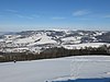
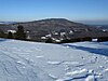
This is a list of mountains and hills of the Rhön, a low mountain range in the Central Uplands of Germany that straddles the three federal states of Bavaria, Hesse and Thuringia. This list includes summits within the Rhön Mountains and its foothills, taking in the Rhön Biosphere Reserve and the nature parks of the Bavarian Rhön, Hessian Rhön and, where it belongs to the Rhön, the Hessian Spessart. The table currently shows mountains over 900 metres high. It will be extended over time.

Six columns in the following table, which on start up is arranged by height in metres (m) above sea level (NHN datum unless otherwise stated based on [1]), are sortable by clicking on the symbols by their headings. In the columns "Mountain, hill, subpeak“ alternative names are given in brackets, in smaller font and italics. In these columns, where entries bear the same name they are disambiguated by the name of the municipality to which they belong shown in brackets and small font. Mountains or hills that have a low isolation or prominence and are therefore not considered independent peaks, are marked with the abbreviation "SP" for "subpeak" and their parent peak is named. In the "state" column, where a mountain or hill lies within two or more states, the state in which the actual summit lies is printed in bold.

A key to the abbreviations is at the bottom of the table.

Mountain,
hill,
subpeak
(coordinates)
Elevation
(m) [1]


Natural region;
Nature park,
Biosphere reserve

Location
Villages
(near/between)


County/counties
(see below)

State/
States
(see below)


Location of
(sights;
nature reserves; Rivers/sources)


Image


Wasserkuppe
(50°29′53″N 9°56′16″E / 50.49806°N 9.93778°E / 50.49806; 9.93778 (Wasserkuppe))
950.0 Wasserkuppenrhön;
Hessian Rhön NP,
Rhön BR
,
,
Reulbach,
,
FD HE highest mountain in
the Rhön and Hesse;
Nordhang Wasserkuppe NR,
,
German Gliding Museum,
;
S: ,
S: Fulda,
S: ,
S: Lütter
The Wasserkuppe seen from south
Dammersfeldkuppe
(50°23′48.8″N 9°51′43.6″E / 50.396889°N 9.862111°E / 50.396889; 9.862111 (Dammersfeldkuppe))
927.9 Dammersfeld Ridge;
Hessian Rhön NP,
Rhön BR
,
,
,
Wildflecken
FD,
KG,
FD,
KG
HE,
BV,
HE,
BV
highest mountain in
RB Lower Franconia;
Wildflecken Training Area;
,
S: ,
S: Kleine Sinn
The Dammersfeldkuppe in Wildflecken Training Area
Kreuzberg
(50°22′13″N 9°58′48″E / 50.37028°N 9.98000°E / 50.37028; 9.98000 (Kreuzberg))
927.8 Kreuzberg Group;
Bavarian Rhön NP,
Rhön BR
Bischofsheim,
,
,
Oberwildflecken,
Sandberg,
Waldberg
NES,
NES,
NES,
KG,
NES,
NES
BV "Holy Mountain of the Franconians",
,
,
,
(large) summit cross;
S: Sinn
View from the Kissinger Hut on the Schwarzenberg looking northeast towards the Kreuzberg
Heidelstein
(West/East Top)
Heidelstein:
Schwabenhimmel:

(50°27′37.8″N 10°0′24.6″E / 50.460500°N 10.006833°E / 50.460500; 10.006833 (Heidelstein))
925.7 m[2]
925.7
912.6


Long Rhön;
Bavarian Rhön NP,
Hessian Rhön NP,
Rhön BR
,
,
Wüstensachsen
NES,
NES,
FD
BV,
BV,
HE
near: Rotes Moor NR,
Heidelstein transmitter,
Rhön Club commemoration site,
,
Long Rhön Nature Reserve (Longe Rhön),
Kesselrain NR;
S: Els,
S: ,
S: ,
S: Ulster
View from the Wachtküppel looking east towards the Heidelstein
Eierhauckberg
(50°24′21.5″N 9°54′4.3″E / 50.405972°N 9.901194°E / 50.405972; 9.901194 (Eierhauckberg))
909.9 Dammersfeld Ridge;
Hessian Rhön NP,
Rhön BR
,
,
,
Wildflecken
KG,
FD,
FD,
KG
BV,
HE,
HE,
BV
Wildflecken Training Area,
View of the Eierhauckberg from the northeast
Abtsrodaer Kuppe
(50°30′15.1″N 9°56′17.4″E / 50.504194°N 9.938167°E / 50.504194; 9.938167 (Abtsrodaer Kuppe))
904.8 Wasserkuppenrhön;
Hessian Rhön NP,
Rhön BR
,
Reulbach,
,
FD HE Basalt summit with good views,
part of the
View looking north to the summit of the Abtsrodaer Kuppe with the villages of Dietges and Brand and the Kuppenrhön in the background
Stirnberg
(50°29′28.6″N 10°2′20.5″E / 50.491278°N 10.039028°E / 50.491278; 10.039028 (Stirnberg))
901.9 Long Rhön;
Bavarian Rhön NP,
Hessian Rhön NP,
Rhön BR
,
Wüstensachsen
NES,
FD
BV,
HE
Long Rhön (Lange Rhön) NR,
Stirnberg bei Wüstensachsen NR,
Hohe Hölle
(50°25′43″N 9°57′41″E / 50.42861°N 9.96139°E / 50.42861; 9.96139 (Hohe Hölle))
893.8 Dammersfeld Ridge;
Bavarian Rhön NP,
Hessian Rhön NP,
Rhön BR
,
,
Oberweißenbrunn
R-G,
FD,
R-G
BV,
HE,
BV

Skilift/piste
View from direction of Mosbach south-southeast to the Hohe Hölle
Steinkopf
(Wüstensachsen)
(50°28′41.1″N 10°1′6″E / 50.478083°N 10.01833°E / 50.478083; 10.01833 (Steinkopf))
888 Lange Rhön;
Bavarian Rhön NP,
Hessian Rhön NP,
Rhön Br
Wüstensachsen,
FD,
R-G
HE,
BV
Basalt blockfield pile,
Steinkopf NR;
,
S:
View from the direction of the Schwarzwald bei Wüstensachsen NR (near the Ottilienstein, on the B 278) east towards the Steinkopf
Himmeldunkberg
(aAbb v. Hohe Hölle)
(50°25′22.5″N 9°57′34.9″E / 50.422917°N 9.959694°E / 50.422917; 9.959694 (Himmeldunkelberg))
887,9 Dammersfeld Ridge;
Bavarian Rhön NP,
Hessian Rhön NP,
Rhön BR
,
,
Oberweißenbrunn,
R-G,
FD,
R-G,
FD
BV,
HE,
BV,
HE
Hexenbuchen (),
(DAV hut);
,
S:
View from Rockenstein looking N to the Himmeldunkberg
Mittelberg
(50°24′34.6″N 9°54′50.9″E / 50.409611°N 9.914139°E / 50.409611; 9.914139 (Mittelberg))
880
[3]
Dammersfeld Ridge;
Hessian Rhön NP,
BR Rhön
,
Oberweißenbrunn,
KG,
R-G,
FD
BV,
BV,
HE
,
tx mast,
tx tower,
skilift;
S: ,
S:
View from the east of the summit region of the Mittelberg and its tx towers
Pferdskopf
(50°29′27.4″N 9°55′14.3″E / 50.490944°N 9.920639°E / 50.490944; 9.920639 (Pferdskopf))
874,9 Wasserkuppenrhön;
Hessian Rhön NP,
Rhön BR
,
FD HE Basalt crags;
S: Lütter
Pferdskopf

Abbreviations[]

Key to the abbreviations used in the table:

Counties (using German car registration plate abbreviations):

States:

Biosphere Reserve:

Nature parks:

Points of the compass:

  • NW = Northwest
  • SE = Southeast

Other:

References and footnotes[]

  1. ^ a b Map services of the Federal Agency for Nature Conservation
  2. ^ Stadt Gersfeld (Rhön), ed. (2002), Gersfeld: Wandern, Wellness, Wintersport : Freizeitkarte 5526, Maßstab 1:25.000 (in German), Fulda: Fa. Parzeller
  3. ^ Berghöhe – diverse Berge laut unbekannte / nicht recherchierte Quelle
Retrieved from ""