List of rivers of Orange County, California

This is a list of rivers of Orange County, California, part of the Greater Los Angeles Area in Southern California.The Santa Ana River and San Gabriel River are the largest in Orange County; their extensive watersheds extend into neighboring Los Angeles, Riverside and San Bernardino Counties. A number of smaller streams originate in or flow largely within Orange County, chief of which are Coyote Creek, Santiago Creek, San Diego Creek, Aliso Creek, and San Juan Creek. Many streams in the area received their names from Spanish explorers in the 18th century.
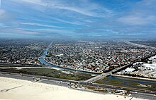
With the exception of mountain regions, Orange County is characterized by dense suburban and urban development. To protect the county's 3 million people from floods, many streams were channelized and/or lined with concrete in the 20th century. In addition, some wholly artificial streams were constructed to drain the large coastal wetlands and floodplains in north Orange County, namely in the Anaheim Bay watershed. Although the purpose of channelization is to carry floodwaters to the sea in an efficient manner, Orange County's streams have also been impacted by stormwater capture projects, to reduce the county's reliance on imported water. Such projects range from Irvine Lake – the county's largest body of fresh water, created by damming Santiago Creek in 1931 – to the extensive Santa Ana River groundwater recharge operations that provide as much as half the domestic water used in the county.
| Watershed | Total area |
Area within Orange County |
%Total OC land area |
|---|---|---|---|
| Aliso Creek[1] | 22,400 acres (91 km2) |
22,400 acres (91 km2) |
4.38% |
| Anaheim Bay– Huntington Harbor[2] |
51,422 acres (208 km2) |
51,422 acres (208 km2) |
10.06% |
| Newport Bay[3] | 97,293 acres (394 km2) |
97,293 acres (394 km2) |
19.02% |
| San Gabriel River[4][5] | 440,960 acres (1,786 km2) |
53,760 acres (218 km2) |
10.51% |
| San Juan Creek[6][7] | 112,640 acres (456 km2) |
102,387 acres (415 km2) |
20.02% |
| San Mateo Creek[8][9] | 88,960 acres (360 km2) |
12,262 acres (50 km2) |
2.39% |
| Santa Ana River[10][11] | 1,696,000 acres (6,869 km2) |
134,701 acres (546 km2) |
26.34% |
San Gabriel River watershed[]

The San Gabriel River flows mainly in Los Angeles County, and forms part of the border between Orange and Los Angeles Counties.
- San Gabriel River
- Coyote Creek
- Carbon Creek
- Fullerton Creek
- Brea Creek
- (La Canada Verde Creek)
- Coyote Creek
Anaheim Bay watershed[]
Santa Ana River watershed[]

The 100-mile (160 km)-long Santa Ana River begins in San Bernardino County and flows through Riverside County before bisecting northern Orange County.
- Santa Ana River
- [n 1]
- Santiago Creek
- Black Star Canyon
- Silverado Canyon
- Modjeska Canyon
- Walnut Canyon
- [n 1]
Newport Bay watershed[]

- (Big Canyon)
- San Diego Creek
Aliso Creek watershed[]

- Aliso Creek
- Wood Canyon Creek
- Sulphur Creek
- Dairy Fork
- Aliso Hills Channel
- English Canyon Creek
- Munger Creek
San Juan Creek watershed[]

- San Juan Creek
- Arroyo Trabuco (Trabuco Creek)
- El Horno Creek
- Cañada Gobernadora
- Trampas Canyon
- Bell Canyon
- Dove Creek
- Tick Creek
-
San Mateo Creek watershed[]
San Mateo Creek is mostly in Riverside and San Diego Counties, with only a small portion in Orange County; however, some of its tributaries extend into Orange County.
- San Mateo Creek
- Cristianitos Creek
- Talega Canyon
- Cristianitos Creek
Coastal streams[]
A number of smaller streams flow into the Pacific Ocean along the Orange County coast. They are listed below from north to south. Waterways indicated in the above lists are italicized, to clarify location:
- Newport Bay
- Moro Canyon
- Emerald Canyon
- Laguna Canyon
- Aliso Creek
- Salt Creek
- San Juan Creek
- San Mateo Creek
Notes[]
- ^ The Talbert watershed would naturally have drained into Santa Ana River but a separate artificial ocean outlet, just to the west of the Santa Ana River mouth, was constructed in the early 1900s.
References[]
- ^ http://ocwatersheds.com/programs/ourws/alisocreek[dead link]
- ^ http://ocwatersheds.com/programs/ourws/anaheim_bay_huntington_harbour[dead link]
- ^ http://ocwatersheds.com/programs/ourws/npb[dead link]
- ^ http://www.waterboards.ca.gov/rwqcb4/water_issues/programs/regional_program/Water_Quality_and_Watersheds/san_gabriel_river_watershed/summary.shtml
- ^ https://dpw.lacounty.gov/lacfcd/sediment/dcon/FactSheet7watershed.pdf
- ^ http://ocwatersheds.com/programs/ourws/sanjuancreek[dead link]
- ^ http://ocwatersheds.com/civicax/filebank/blobdload.aspx?BlobID=10364[dead link]
- ^ http://ocwatersheds.com/programs/ourws/sanmateocreek[dead link]
- ^ http://sanmateocc.org/files/sanmateocreekwatershedprofile.pdf
- ^ http://ocwatersheds.com/programs/ourws/snariver[dead link]
- ^ http://www.sawpa.org/wp-content/uploads/2014/01/3.0-Watershed-Setting_tc_11-20-2013_FINAL1.pdf
See also[]
External links[]
- Rivers of Orange County, California
- Lists of landforms of California
- Lists of rivers of the United States