List of tallest buildings and structures in Belfast

This list of the tallest buildings and structures in Belfast ranks buildings and structures in Belfast, Northern Ireland by height. There are at least 10 structures in the city taller than 80 metres (260 ft) and there are at least 36 habitable buildings in the city taller than 45 metres (148 ft).
Tallest by category[]

- The tallest building in Belfast is the Obel Tower at 86-metre (282 ft). It is the tallest building in Northern Ireland and the island of Ireland.
- The tallest structure in Belfast is the Black Mountain Tv mast at 228.6 metres (750 ft).
- The tallest free standing and occupied structure is the Harland and Wolf shipbuilding gantry crane Samson at 106 metres (348 ft).
- The tallest chimney is the Belfast City Hospital chimney at 95 metres (312 ft).
- The tallest church is Belfast (St. Anne's) Cathedral at 80 metres (262 ft).
- The tallest clock is the Albert Memorial Clock at 34.4m (113 feet).
Belfast's tallest structures[]
These lists rank the 8 tallest structures in Belfast by total height.
| Rank | Name | Use | Image | Height (m) | Height (ft) | Floors above ground | Year of completion | Notes |
|---|---|---|---|---|---|---|---|---|
| 1 | Black Mountain transmitting station | TV mast |
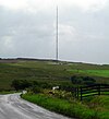
|
228.6 | 750 | N/A | 1959 | [1] |
| =2 | Divis transmitting station | TV mast | 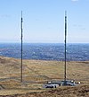
|
166 | 545 | N/A | 2011 | [2] |
| 4 | "Samson" | Shipbuilding Gantry Crane |  |
106 | 348 | N/A | 1974 | [3] |
| 5 | Belfast Ship repair Quay crane | Ship repair Crane | 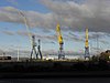
|
104 | 341 | N/A | unknown | [4] |
| 6 | "Goliath" | Shipbuilding Gantry Crane | 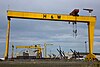
|
96 | 316 | N/A | 1969 | [3] |
| 7 | Belfast City Hospital Chimney | Chimney | 
|
95 | 312 | N/A | 1986 | [5] |
| 8 | Grand Central Hotel | Hotel | 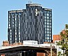
|
93 (Structure height (with 1 plant floor, top of elevator shaft and radio mast now included)) | 305 (Structure) | 23 | 1975 | [6] |
| 9 | Obel | Residential | 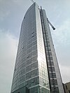
|
86 | 281 | 28 | 2010 | [9] |
| 10 | St Anne's Cathedral (Church of Ireland) | Church | 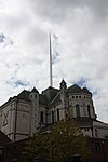
|
80 | 262 | N/A | 2007 | [10] |
Belfast's tallest habitable buildings[]
This list is the tallest habitable buildings in Belfast by architectural height.
| Belfast tallest Buildings | ||||||||
|---|---|---|---|---|---|---|---|---|
| Rank | Name | Use | Image | Height (m) | Height (ft) | Floors (above ground) |
Year of completion | Notes |
| 1 | Obel | Residential |
|
86 | 282 | 28 | 2010 | [9] |
| 2 | Grand Central Hotel | Hotel |
|
80 (Architectural height) | 262 (Building) | 23 | 1975 | [6] |
| 3 | Belfast City Hospital Tower | Hospital | 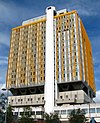
|
76 | 249 | 15 | 1986 | [11] |
| 4 | City Quays 3 | Office |  |
74.5 | 244 | 16 | 2021 (topped out) | [12][13]** |
| 5 | The Ewart
(Nicknamed "R2D2" shape of building resembles the famous droid) |
Office |  |
73* | 240 | 17 | 2021 (topped out) | [14][15]
** |
| 6 | Belfast International Hilton Hotel | Hotel | 
|
63 | 207 | 16 | 1998 | [16] |
| 7 | BT Riverside Tower | Office | 
|
62 | 203 | 14 | 1998 | [17] |
| 8 | Divis Tower | Residential | 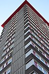
|
61 | 200 | 20 | 1966 | [18] |
| 9= | The Boat | Office/Residential | 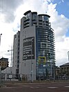
|
57 | 187 | 15 | 2010 | [19]*** |
| 9= | Royal Victoria Hospital Critical Care Building | Hospital | 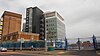
|
57 | 187 | 12 | 2012 | [20][21] **** |
| 11= | Linum Square | Office | 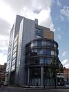
|
55 | 180 | 13 | 2005 | [22] |
| 11= | Causeway Tower | Office | 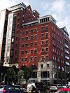
|
55 | 180 | 13 | 2004 | [23] |
| 11= | Great Northern Tower | Office | 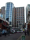
|
55 | 180 | 13 | 1992 | [24] |
| 14 | Ulster University Belfast Campus | University | ** | 52 (topped out ) ***** | 171 | 13 | 2021 | [25] |
| 15 | Grainne House | Residential | 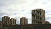
|
52 | 171 | 17 | 1968 | [26] |
| 16 | Europa Hotel | Hotel | 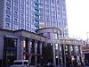
|
51 | 167 | 13 | 1971 | [27] |
| 17 | Lanyon Plaza | Office | 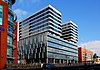
|
50 | 164 | 12 | 2014 | [28] |
| 18= | Bedford House | Office | 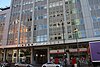
|
49 | 161 | 12 | 1966 | [29] |
| 18= | River House | Office | 
|
49 | 161 | 14 | 1970 Building reclad in 2018. | [30][31] |
| 18= | Ferndale House
Parkdale House Riverdale House |
Residential |  |
49 | 161 | 15 | 1965 | [32][33][34] |
| 18= | Coolemoyne House
Rathmoyne House |
Residential |  |
49 | 161 | 15 | 1962 | [35][36] |
| 25 | Queen's University Medical Biology Centre
(MBC) |
University | 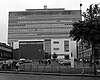
|
48 | 158 | 12 | 1969 | [37] |
| 26 | Swanston House 41-49 Queen street | Residential (student) | 
|
47 | 155 | 14 | 2016 | [38] |
| 27= | 14 Great Victoria Street | Office | 
|
46 | 151 | 11 | 2003 | [39] |
| 27= | Fanum House | Office | 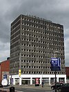
|
46 | 151 | 13 | 1965 | [40] |
| 27= | Dundonald house | Office | 
|
46 | 151 | 12 | early 1960s | [41][42]
|
| 27= | Ashby Building | University | 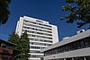
|
46 | 151 | 11 | 1965 | [43] |
| 27= | 101 York Street | Residential (student) | 
|
46 | 151 | 14 | 2021 (topped out) | [44] |
| 32= | Kilbroney House | Residential | 
|
45 | 148 | 15 | 1967 | [45] |
| 32= | Carnet House | Residential | 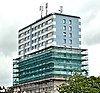
|
45 | 148 | 15 | 1966 | [46] |
| 32= | Bradbury court | Residential |
|
45 | 148 | 15 | Early 1960s | [47] |
| 32= | FX, 14-18 Montgomery street | Residential | 
|
45 | 148 | 15 | 2019 | [48] |
| 32= | Maldron hotel | Hotel | 
|
45 | 148 | 15 | 2018 | [49] |
| 32= | Elms BT2, McClintock Street | Residential (student) | 
|
45 | 148 | 16 | 2018 | [50] |
*Note: have seen this building height incorrectly listed as 62m in recent planning applications and emporis, that is height of lower roof/arm of building (easy mistake from side elevation) but ignores last 3 floors, to upper roof (not a plant).
**Image should be updated when building is complete
***Recent applications have height as 57m not 62m assuming similar error with critical care building
****New children's hospital application reveals original height was only above sea level not base to roof so 63m is height above sea level
***** Height above sea level once again being quoted as height (56m) but base to top it is 52m
Tallest non-habitable buildings[]
List of tallest non Habitable buildings over 45m tall in Belfast. Non-Habitable building refers to a building where most of the height is taken up by an architectural feature which is not habitable such as a spire, or storage space.
| Rank | Name | Use | Image | Height (m) | Height (ft) | Year of Construction | Notes |
|---|---|---|---|---|---|---|---|
| 1 | St Anne's Cathedral | Anglican Cathedral (Church of Ireland) |
|
80 | 262 | 2007 | [10] |
| 2 | St Patrick's Church, Belfast | Roman Catholic chapel | 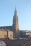
|
55 | 180 | 1877 | [51] |
| 3 | West Twin Silos | Warehouse | 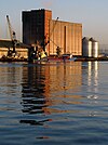
|
54 | 177 | 1963 | [52] |
| 4 | Belfast City Hall | Government Building | 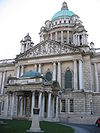
|
53 | 174 | 1906 | [53] |
| 5 | Carlisle Memorial Church | Former Methodist Church now a venue | 
|
52 | 171 | 1875 | [54] |
| 6 | St Peter's Cathedral, Belfast | Roman Catholic Cathedral | 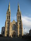
|
50 | 164 | 1866 | [56] |
Tallest demolished[]
Tallest buildings and structures in Belfast over 45m to have been demolished.
| Name | Use | Image | Height (m) | Floors | Notes |
|---|---|---|---|---|---|
| Divis Transmitting station (old) | TV Masts | Mast A =140.7
and Mast B=139.5 |
N/A | Built in 1957
Replaced in 2011 | |
| Power station West 3 Chimneys | Power station Chimneys | 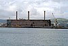
|
80 | N/A | Was opened in 1962, and closed in 2002 as move towards green energy began. Chimneys were demolished in 2007.[57] |
| Churchill House | Office | 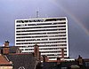
|
66 (not including mast) | 18 | When built in 1966 it was Belfast's tallest building. Was occupied by Northern Ireland civil servants. Demolished in 2004. Now Victoria Square Shopping centre is where it once stood.[58] |
| Greeves' (Cupar street) mill chimney | Chimney | 66 | N/A | When built it was the tallest chimney in Ireland and was until at least 1923. It had to be felled for safety reasons as it quickly deteriorated.[59] | |
| Belfast Wheel | Observation wheel | 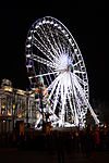
|
60 | N/A | Was opened 2007 and closed 2010, due to blocking listed Belfast City hall and titanic memorial. Talks of moving it to the Titanic quarter led to nothing. |
Potential tall buildings in belfast[]
Section covers buildings and structures under construction, had planning permission approved and have been proposed for Belfast. Exact heights stated in this section are taken directly from building plans found at [60] and most recent approvals are announced online,[61] where older ones are found in the previous reference.
Under construction[]
This lists buildings that are currently under construction. (Currently none but keeping table structure for future projects as plenty are approved see below.)
| Name | Image | Use | Height (m) | Floors | Notes |
|---|

Approved[]
This lists buildings that have been given planning permission to be constructed in Belfast.
| Name | Use | Height (m) | Floors | Notes | |
|---|---|---|---|---|---|
| Royal Victoria Hospital energy centre | Power station | 70 (Flue chimney stack) | N/A | Granted planning permission in Belfast City council's 14/12/21 planning meeting [62]This will not be a 'habitable building' but a prominent structure. | |
| One Grosvenor Gate | Office | 62.3 | 14 | Approved March 2021 [63] | |
| Royal Children's Hospital | Hospital | 61 (structure 65) | 12 | Approved 2020,[21] Demolition of Bostock House underway 2021. | |
| Sirroco waterside quays office | Office | 58.3 | 13 | Approved 2020 [64] | |
| The Residence | Residential | 57.5 | 19 | Approved in November 2020 planning meeting. Site has been put up for sale in 2021.[65] | |
| Lanyon View Dalton street | Residential | 56.7 | 17 | Approved 2019 and again in 2021 after dispute.[66] | |
| Belfast Harbour 480 mW gas power station | Power station | 54.2 | N/A | Approved 2019 [67]Not a 'habitable building' but a prominent structure. | |
| River Walk | Residential | 54 | 17 | Approved 2020 [68] | |
| 81-87 Academy street | Residential | 54 | 16 | Approved 2019 Land bought by Tribeca Developers 2021 [69] Reapproved 24/11/2021 | |
| Bruce Street Student accommodation | Student accommodation |
|
15 | [70] Full planning approved on Belfast council planning meeting 14/12/2021 | |
| Financial Services Campus Titanic quarter | Office and Education | ~45-55 | 12 | Approved 2009, archaeology condition discharged 2015 and waiting on land to be decontaminated.[71] | |
| Bedford yard | Aparthotel | 45 | 13 | Approved 2020 and again in 2021 after dispute.[72] |
Proposed[]
This lists buildings that have only been proposed to be built in Belfast.
| Name | Use | Height (m) | Floors | Notes |
|---|---|---|---|---|
| Olympic Tower | Residential | 97.5 | 30 | Pre-planning accepted 2019, full planning application yet to come. |
| Abercorn tower | Hotel | 94 (100.5 total height) | 30 | Outline planning permission from Titanicquarter masterplan. |
| City Quay 4 | Residential | 90+ | 22+ | Belfast Harbour proposal in 2019 [73] |
| Queen' Quay Masterplan | Mixed use | over 85 ,
approx 60 and approx 60 |
20 plus,
approx 15 and 15 |
Details found in reference which is the ongoing consultation by the department of the communities, funded by regional city deal (high chance of happening).
Masterplan has three towers of significant height, the first is shown to be slightly taller than the Obel Tower and mirrors the proposed tower across the M3 at the Odyssey quay, with apartments starting at the twentieth floor above a hotel and retail ground floor unit. Two other 60m apartment towers with retail units are also planned.[74] |
| Odyssey quays landmark tower | Residential | 84.8+ | 28 | Part of Odyssey Quays master plan proposed 2019, aviation report in 2020 cites tower as over 36m above 48.7m height limit [75] |
| Weaver's Cross Tower | Mixed use | 78 (in new proposal) | 23 (in old proposal) | Translink proposing a development, Weavers Cross, around the under construction transport hub.
Proposed in 2017 with initial proposal of application notice [76] The development was pitched to developers at the end of November 2020. This tower was pitched to hide the back of the Europa Hotel. New proposal of application notice in 2021, tower remains but no reference to exact floor height as before.[77] In consultation for new plan tower height revealed to be 78m [78] |
| Plater's Yard | mixed use | 73 | unknown | Part of titanic quarter masterplan, plot 12, land currently for sale. |
| Plot 19 Titanic quarter | mixed use | 66.5 | unknown | Part of Titanic quarter masterplan |
| 21-29 Corporation street | Mixed use | 63 | 19 | Proposed in 2018, pre planning accepted, renders of design produced by developer Macleer and Rushe in 2020. Formal planning application imminent. Note site has previous applications up to 20 stories accepted planning permission including offices and 250 bedroom hotel but nothing has come of it yet with site still derelict.
Full Planning application submitted August 2021 [79] |
| The Grattan | Mixed use but mainly residential, with commercial ground floor | 60+ | 20 (counted from renders plus open top area) | Will replace the derelict Fanum House ( which features in the list of tallest buildings).
Community consultation process finished in February 2021 with a formal planning application to follow.[80] |
| Centrally placed between North andDonegal street | Residential | 60 | 15 | Outline planning permission as part of Tribeca master plan |
| One Bankmore square design 2 | Office | ~57 | ~12 | Redesign of previously approved proposal with smaller footprint and similar height.[81] |
| Fairing The Loft Lines | Residential | 57 | 18 | Part of Residential development in Titanic quarter pre application notice is in, with public consultation.[82] Full planning application submitted 22/09/21 [83] Note in this application docs also show height of TQ master plan towers. |
| Odyssey quays gateway office | Office | 55+ | 15 | Part of Odyssey Quays master plan proposed 2019 |
| Arc 2 | Residential | 51.5 | 16 | Outline planning permission form Titanic Quarter masterplan |
| Holmes Street | Residential | approx 50 | 15 | Outline planning application [84] |
| 35-41 queens square | Residential | 47 | 15 | Pre planning application submitted with digital community consultation beginning 29 March. A 16 story tower was previously approved in same location. 25 August 2021 full planning submitted.[85] |
| Junction of Rosemary street and North street | Office | 46.5 | 10 | Outline planning permission granted as part of Tribeca masterplan |
| Maker The Loft Lines | Residential | 45 | 14 | Part of Residential development in Titanic quarter pre application notice is in, with public consultation [82] Full application submitted |
List of Unbuilt Buildings[]
Table of tallest proposed buildings that never came to fruition, either due to planning permission or financial issues.
| Name | Height (m) | Floors | Notes |
|---|---|---|---|
| Aurora building | 109 | 37 | [86][87] Site currently a petrol station, planning was refused mainly due to precarious financial state of developer and opposition to building height. |
| Bedford Square phase 2 (original application) | 104.5 | 26 | [88] Gained planning approval in 2005 but plans were scaled down after property market crash in 2008. A 17 storey office is currently under construction on its proposed site. |
| Belfast Vetro Hotel | 100 | 26 | [89][90] |
| Sirocco Quay | 92 | 30 | [91] Had outline planning permission but was changed into a 17 storey office development city quays 3 which is currently under construction |
| Queen's Quay block E1 | 92 | 30 | [92] Land bought by another developer creating their own masterplan. |
| Odyssey quays tower | 88 | 29 | [93] previous withdrawn proposal, there is currently a 28 storey tower proposed on the same site. |
| Murray Tobacco works | 84.5 | 28 | [94] Site was bought by Translink who are using it as part of a mixed use development around their transport hub called Weaver's Cross. |
| Midland Building | 76 | 25 | [95] site is now student accommodation |
| St George's Gate | 76 | 24 | [96] Application withdrawn, still seen as a development opportunity site |
| Hope and History | 70 | 21 | [97] Proposed in 2005, planning refused. |
| Brunswick Street tower | 70 | 17 | [98] Planning was approved, land is being used for Mcclintock street student accommodation and Maldron hotel, there is still unused land on the site for this to be potentially built. |
| Bridge end towers | 61 | 19 | [99] Application withdrawn, site still vacant. |
History of Belfast's tallest building[]
Table of the history of the tallest building in Belfast by Architectural height
| Name | Years tallest | Height (m) | Image |
|---|---|---|---|
| St. Peter's Cathedral (Roman Catholic) | 1866-1875 | 50 |
|
| Carlisle Memorial Church (Methodist) | 1875-1877 | 52 |
|
| St Patrick's Church (Roman Catholic) | 1877-1966 | 55 |
|
| Churchill House | 1966-1975 | 66 |
|
| Windsor House (Grand Central Hotel) | 1st
1975-2007 Joint 1st 2007-2010 |
80 |
|
| Belfast (St. Anne's) Cathedral
(Church of Ireland) |
Joint 1st
2007-2010 |
80 |
|
| Obel Tower | 2010- | 86 |
|
See also[]
References[]
- ^ "Black Mountain TV Mast emporis". emporis.com.
- ^ a b "Divis TV Mast". emporis.com.
- ^ a b "H and W cranes". theyard.info.
- ^ "Google Earth".
- ^ "Belfast City Hospital Chimney google earth height taken from elevation of top above sea level subtracted by the base's elevation". Google Earth.
- ^ a b "Windsor House". Skyscrapernews.com. 19 February 2000. Retrieved 4 February 2010.
- ^ a b "Belfast Grand Central Hotel: Hastings unveils plan to transform Windsor House into a £30m hotel". Belfasttelegraph. Retrieved 29 September 2018.
- ^ a b "Google Earth".
- ^ a b "Z/2011/0577/F | Continuation of curtain walling glazing system to the ground floor of blocks 2 and 3 elevations including provision of entrance doors | Donegall Quay Belfast BT1 3EE". epicpublic.planningni.gov.uk. Retrieved 11 March 2021.
- ^ a b "Belfast Cathedral". belfastcathedral.org.
- ^ "Belfast City Hospital Tower". Skyscrapernews.com. 19 February 2000. Retrieved 4 February 2010.
- ^ "LA04/2017/1090/RM | City Quays 3 - erection of 16 storey office accommodation (74 metres maximum height) comprising 23,976 sq metres of gross floorspace, associated access, public realm and other ancillary development. | Lands approximately 100m north of M3 Cross Harbour Bridge and bounded by the River Lagan to the east Donegall Quay and Clarendon Dock to the north Corporation Square and Clarendon Quay to the west". epicpublic.planningni.gov.uk. Retrieved 11 March 2021.
- ^ Harbour, Belfast. "Belfast Harbour and Farrans Construction Reach Topping Out Milestone on City Quays 3". Belfast Harbour. Retrieved 6 October 2021.
- ^ "LA04/2015/0264/F | Bedford Square Development Phase 2 to include the conservation, alteration, refurbishment and extension to the listed Ewart Building for office use and a 17 Storey new build mixed use development, with ground floor retail, offices above and associated basement car parking; and completion of a new civic square.(Amended Description and Amended Plans) | Lands bounded by Bedford Street INI building McClintock Street and Franklin Street BT2 7GP". epicpublic.planningni.gov.uk. Retrieved 11 March 2021.
- ^ "Topping out ceremony marks milestone at 'The Ewart'". BDC Magazine. 24 August 2021. Retrieved 31 August 2021.
- ^ "Belfast International Hilton Hotel". Skyscrapernews.com. 19 February 2000. Retrieved 4 February 2010.
- ^ "BT Riverside Tower". Skyscrapernews.com. 19 February 2000. Retrieved 4 February 2010.
- ^ "Divis Tower". Skyscrapernews.com. 19 February 2000. Retrieved 4 February 2010.
- ^ "The Boat". Skyscrapernews.com. 19 February 2000. Retrieved 4 February 2010.
- ^ "Z/2006/2083/F | Construction of a 12 level hospital building, 63m in height, with a rooftop helipad, to include A&E, critical care, theatres, burns unit and education. | Royal Victoria Hospital, Grosvenor Road, Belfast". epicpublic.planningni.gov.uk. Retrieved 3 September 2021.
- ^ a b "LA04/2018/2157/F | A new children's hospital and associated infrastructure incorporating the demolition of Bostock House. To include the provision of hard and soft landscaping, an entrance feature at the Falls Road pedestrian access, signage, external lighting and associated site works. | Location of existing Bostock House and part of the land adjacent on the Royal Group of Hospitals site 274 Grosvenor Road Belfast BT12 6BA". epicpublic.planningni.gov.uk. Retrieved 2 September 2021.
- ^ "Linum Square". Skyscrapernews.com. 19 February 2000. Retrieved 4 February 2010.
- ^ "Causeway Tower". Skyscrapernews.com. 19 February 2000. Retrieved 4 February 2010.
- ^ "Great Northern Tower". Skyscrapernews.com. 19 February 2000. Retrieved 4 February 2010.
- ^ "LA04/2020/0625/NMC | Minor amendments to the external envelope treatments and design development of external landscaping of the University of Ulster's Greater Belfast Development campus previously approved under planning application Z/2012/0261/f and as further amended under applications Z/2014/1245/f and LA04/2017/1763/NMC | York Street/Donegall Street/Frederick Street Belfast BT15 1ED". epicpublic.planningni.gov.uk. Retrieved 8 March 2021.
- ^ "Grainne House". emporis.com.
- ^ "Europa Hotel". Skyscrapernews.com. 19 February 2000. Retrieved 4 February 2010.
- ^ "Lanyon Plaza". Skyscrapernews.com. 19 February 2000. Retrieved 4 February 2010.
- ^ "Bedford House". Skyscrapernews.com. 19 February 2000. Retrieved 4 February 2010.
- ^ "River House". Skyscrapernews.com. 19 February 2000. Retrieved 4 February 2010.
- ^ https://twitter.com/jp_biz/status/855047973100814337. Missing or empty
|title=(help) - ^ "Riverdale house".
- ^ "Ferndale House".
- ^ "Parkdale house".
- ^ "Rathmoyne House".
- ^ "Coolemoyne House".
- ^ "Google Earth".
- ^ "Application Documents".
- ^ "14 Great Victoria Street". Skyscrapernews.com. 19 February 2000. Retrieved 4 February 2010.
- ^ "Fanum House". Skyscrapernews.com. 19 February 2000. Retrieved 4 February 2010.
- ^ "Dundonald House Google earth height taken as elevation above sea level of top subtracted from that of base". Google Earth.
- ^ "DundonaldHouse proposed for listing". Belfasttelegraph. Belfast telegraph.
- ^ "Ashby Building". Skyscrapernews.com. 19 February 2000. Retrieved 4 February 2010.
- ^ "101 York Street".
- ^ "Kilbroney House". Skyscrapernews.com. 19 February 2000. Retrieved 4 February 2010.
- ^ "Carnet House". Skyscrapernews.com. 19 February 2000. Retrieved 4 February 2010.
- ^ "Bradbury Court". emporis.com.
- ^ "LA04/2018/2885/NMC | non Material Change Z/2012/0606/F | FX Building 14 Montgomery Street Belfast".
- ^ "LA04/2017/1081/F | Internal reconfiguration to previously approved 206 bedroom hotel (ref LA04/2016/1050/NMC and LA04/2015/0418/f) to create an additional 31 bedrooms within the approved built form with no additional increase in floor area, providing a total of 237 bedrooms | 20 Brunswick Street Belfast BT2 7GE". epicpublic.planningni.gov.uk. Retrieved 11 May 2021.
- ^ "McClintock Street Student Accommodation".
- ^ "1877 – St Patrick's Catholic Church, Belfast". Archiseek - Irish Architecture. 23 September 2009. Retrieved 24 February 2021.
- ^ "Google Earth".
- ^ "Belfast City Hall". Skyscrapernews.com. 19 February 2000. Retrieved 4 February 2010.
- ^ "Google Earth".
- ^ "1876 – Carlisle Memorial Methodist Church, Belfast, Co. Antrim". 13 August 2013.
- ^ "Google Earth".
- ^ "Tall chimneys come down to earth". 6 July 2007.
- ^ http://www.bbc.co.uk/northernireland/yourplaceandmine/belfast/churchill_house.shtml |}
- ^ "National Museums NI".
- ^ "Simple Search".
- ^ "Home".
- ^ "LA04/2021/1492/F | Proposed energy centre including ancillary development, access, landscaping and associated miscellaneous works. | Royal Victoria Hospital Grosvenor Road Belfast BT12 6BA". epicpublic.planningni.gov.uk. Retrieved 13 December 2021.
- ^ "LA04/2020/1666/F | Demolition of existing two storey building and erection of an office development with heights of 9-14 storeys with landscaping, parking, and associated development. | Lands at 102-127 Grosvenor Road and adjoining The Westlink/Grosvenor Road junction Belfast BT12 4GH". epicpublic.planningni.gov.uk. Retrieved 2 September 2021.
- ^ "LA04/2018/0448/F | Erection of 13 storey Grade A office building with ground floor, first floor and mezzanine cafe/bar/restaurant uses (sui generis), ground floor retail unit, lobby/reception area, basement and deck car parking, servicing (refuse/recycling/cycle storage/changing facilities), landscaping/public realm works, temporary pocket park, pedestrian/ cycle access route from Bridge End, temporary pedestrian/cycle access to riverfront, associated access arrangements to Short Strand and Bridge End and other associated infrastructural works | Lands at former Sirocco Works Short Strand and adjacent to Bridge End and the River Lagan Belfast". epicpublic.planningni.gov.uk. Retrieved 2 September 2021.
- ^ "LA04/2019/2387/F | Residential development comprising 151 apartments and ancillary uses including; management suite, communal space, reception area and servicing (refuse/recycling/bicycle storage) and plant equipment; and associated car parking and public realm improvements to Scrabo Street, Station Street and Middlepath Street. | Land adjacent to Quay Gate House 15 Scrabo Street Belfast BT5 4D: footpaths and public realm at Scrabo Street Station Street and Middlepath Street". epicpublic.planningni.gov.uk. Retrieved 2 September 2021.
- ^ "LA04/2018/2649/F | Demolition of existing building and construction of 178No. apartments, a gym, 3No. retail units and associated car parking and landscaping. | lands at 3-9 Dalton Street (Bordered by Middlepath Street and Bridge End) Belfast". epicpublic.planningni.gov.uk. Retrieved 2 September 2021.
- ^ "LA04/2017/0878/F | Erection of 480MW Combined Cycle Gas Turbine (CCGT) Power Station comprising turbine hall/heat recovery steam generator building with 50m exhaust stack, air cooled condenser, 2 storey administration building, 2 storey workshop building, gas insulated substation, gas compressor station, gas pressure reduction station, associated water and fuel tanks and other associated infrastructure and ancillary development including provision of site access and road works to facilitate extension to pedestrian footways and delineation of a right hand turn lane. Construction of new Above Ground Installation (AGI) at Kinnegar Army Barracks and new underground pipeline along Airport Road West, Esplanade Road with option of also following Heron/Moscow Road and which will connect the Power Station Site to the existing gas transmission infrastructure at Kinnegar Barracks. | Planning application site includes the power generation station site located on lands approx. 65m SE of 101 101a 101B and 103 Airport Road West Belfast Harbour Estate Belfast and also the route of the underground gas pipeline (UGP) connection from Kinnegar Army Barracks to the Power Station Site along the following roads: Airport Road West Esplanade Road Moscow/Heron Road. An above ground installation is located in SW corner of Kinnegar Army Barracks adjacent to Kinnegar WwTW". epicpublic.planningni.gov.uk. Retrieved 2 September 2021.
- ^ "LA04/2019/0517/F | Residential development comprising 154 units and ground floor retail unit, including reception and management suite area, internal and external communal space, open space and environmental improvements, car parking with access of Mays Meadow, bin storage, cycle parking, plant equipment and storage. (amended plans) | El Divino Nightclub and car park and adjacent open space Mays Meadow Belfast BT1 3PH". epicpublic.planningni.gov.uk. Retrieved 2 September 2021.
- ^ "LA04/2019/2257/F | Erection of 16 storey residential building comprising 105 units (60 x one bed and 45 x two bed), ancillary ground floor uses including management suite, cafe, servicing (refuse/recycling/cycle storage/general storage), roof terrace, plant room, substation and associated public realm works. (Amendment to planning permission reference (LA04/2017/2811/F). | 81-87 Academy Street & 2-6 Exchange Street Belfast BT1 2LS". epicpublic.planningni.gov.uk. Retrieved 2 September 2021.
- ^ "LA04/2021/2242/F | Erection of new 15no storey purpose built student accommodation building and associated development (amended scheme from that previously approved under application reference LA04/2018/2602/f) | Lands bounded by Little Victoria Street Bruce Street and Holmes Street Belfast". epicpublic.planningni.gov.uk. Retrieved 13 December 2021.
- ^ "Z/2009/1603/F | Erection of Financial Services Campus building comprising 55,740 sq m gross floorspace of Class B1(a) office and Class A2 financial, professional and other services, together with other mixed ground floor and mezzanine uses (comprising retail (Class A1), community and cultural uses (Class D1), restaurants, bars and cafes (sui generis) - totalling 5,937 sq m gross), basement and deck car parking (583no. spaces), access road, landscaping and ancillary infrastructural works | Land east of Queen's Road, 175m north of Sydenham Road, Queen's Island, Belfast". epicpublic.planningni.gov.uk. Retrieved 2 September 2021.
- ^ "LA04/2020/0659/F | Refurbishment of existing four storey terrace including alteration, extension to rear, partial demolition and reinstatement. Part change of use from art galleries to two cafes at ground floor. Retention of offices within existing building at second, third and fourth floor. Erection of new 13 storey aparthotel building to rear and associated works including public realm improvements [Amended Scheme] | 29-33 Bedford Street Belfast BT2 7EJ". epicpublic.planningni.gov.uk. Retrieved 2 September 2021.
- ^ "Belfast Harbour ramps up development prospects | The Planner". www.theplanner.co.uk. Retrieved 14 February 2021.
- ^ "Queen's Quay Pre-Application Community Consultation | Department for Communities". Communities. 18 November 2021. Retrieved 13 December 2021.
- ^ "LA04/2019/2882/O | Renewal of outline planning permission ref. Z/2009/1309/O for mixed use development including a maximum of 798 residential units (up to 73,420 sq. m) with associated amenity space, two hotels (up to 22,438 sq.m), offices 9up to 4370 sq.m), retail services (up to 905 sq.m), leisure facilities (up to 1303 sq.m), community and cultural uses (up to 1570 sq.m), cafes/bars/restaurants (up to 2824 sq.m), public open space, multi storey car parking (up to 55,612 sq.m) and associated works including related infrastructure improvements. | Queens Quay Belfast(lands between M3 and odyssey complex)". epicpublic.planningni.gov.uk. Retrieved 28 April 2021.
- ^ "LA04/2017/2309/PAN | Mixed use regeneration development associated with adjacent public transport interchange comprising, commercial, retail, hotel and residential uses, including elements of car parking, public realm and associated infrastructure and highway improvements. | Vacant lands to the west of West Link (A12) and south of Grosvenor Road; Lands at Grosvenor Road and intersection of Grosvenor Road and Durham Street; Lands to south of Grosvenor Road east of Durham Street and north of Glengall Street; Lands at Glengall Street; Lands between Glengall Street and Hope Street including Europa Bus Station Great Victoria Rail Station Great Victoria Street mall and surface car parks at St Andrews Square; Translink lands to west of Durham Street and north of Murry's Tobacco Exchange". epicpublic.planningni.gov.uk. Retrieved 2 September 2021.
- ^ "LA04/2021/1971/PAN | Proposed mixed use regeneration development comprising office, residential, retail, open space, commercial, and active travel uses, on lands surrounding the new Belfast Transport Hub to the east and west of Durham St and south of Grosvenor Rd. | Lands to east of West Link (A12) and south of Grosvenor Road; Lands at Grosvenor Road and intersection of Grosvenor Road and Durham Street; Lands to the east of Durham Street and north of Glengall Street; Lands at Glengall Street; Lands between Glengall Street and Hope Street including Europa Bus Station Great Victoria Rail Station surface car parks at St Andrew?s Square; Translink lands to west of Durham Street south of BT Exchange building and north of Murray?s Tobacco Works". epicpublic.planningni.gov.uk. Retrieved 2 September 2021.
- ^ "Weaver's Cross Masterplan". Virtual Engage. Retrieved 6 October 2021.
- ^ "LA04/2021/2016/F | Demolition of existing multi-storey car park and the erection of 298no. build for rent apartments (19 storey) including ground floor commercial unit (A1/A2), car/cycle parking provision along with associated development. | 21-29 Corporation Street & 18-24 Tomb Street Belfast". epicpublic.planningni.gov.uk. Retrieved 2 September 2021.
- ^ "To let: Belfast's 'Golden Mile' tower block in £45m revamp". belfasttelegraph. ISSN 0307-1235. Retrieved 14 February 2021.
- ^ "Kainos sets sights on new multimillion pound city centre headquarters". Kainos. Retrieved 14 February 2021.
- ^ a b "The Loft Lines". www.theloftlines.com. Retrieved 26 May 2021.
- ^ "LA04/2021/2280/F | Mixed use, mixed tenure residential-led development of 778 apartments in three buildings with internal and external amenity space; flexible commercial/community floorspace (convenience store with hot food counter/A1/A2/D1 uses/cafe/bar/restaurant); public realm including public square and waterfront promenade; cycle and car parking and associated landscaping, access roads, plant and site works including to existing river revetmet | Lands adjacent to and south east of the river Lagan west of Olympic Way of Queen's road Queen's Island Belfast BT2 9EQ". epicpublic.planningni.gov.uk. Retrieved 13 December 2021.
- ^ "LA04/2021/2786/O | 15 storey residential development, 32No, 1 bedroom apartments, 35No. 2 bedroom apartments and 1No. studio apartment. | Lands at Holmes Street to the rear of 15-21 Bruce Street Belfast". epicpublic.planningni.gov.uk. Retrieved 13 December 2021.
- ^ "LA04/2021/1985/F | Proposed erection of 15no. storey building comprising 60no. apartments with ancillary facilities and all other associated site works (amendment to previous approval Z/2011/0472/F). | 35-41 Queen's Square Belfast BT1 3FG". epicpublic.planningni.gov.uk. Retrieved 23 September 2021.
- ^ "Belfast's 'tallest building' site plans are withdrawn". BBC News. 20 February 2011. Retrieved 11 May 2021.
- ^ "Aurora, Belfast - Building #5150". www.skyscrapernews.com. Retrieved 11 May 2021.
- ^ "Bedford Square Phase 2, Belfast - Building #4607". www.skyscrapernews.com. Retrieved 11 May 2021.
- ^ "Vetro, Belfast - Building #6193". www.skyscrapernews.com. Retrieved 11 May 2021.
- ^ "£50m hotel scheme for Belfast". belfasttelegraph. ISSN 0307-1235. Retrieved 11 May 2021.
- ^ "Sirocco Quay, Belfast - Building #6389". www.skyscrapernews.com. Retrieved 11 May 2021.
- ^ "Queens Quay Block E1, Belfast - Building #4846". www.skyscrapernews.com. Retrieved 11 May 2021.
- ^ "Odyssey Quays, Belfast - Building #6931". www.skyscrapernews.com. Retrieved 11 May 2021.
- ^ "Murray Tobacco Works, Belfast - Building #5229". www.skyscrapernews.com. Retrieved 11 May 2021.
- ^ "Midland Building, Belfast - Building #6128". www.skyscrapernews.com. Retrieved 11 May 2021.
- ^ "St Georges Gate Building C, Belfast - Building #5344". www.skyscrapernews.com. Retrieved 11 May 2021.
- ^ "Hope and History, Belfast - Building #4880". www.skyscrapernews.com. Retrieved 11 May 2021.
- ^ "Brunswick Street Tower, Belfast - Building #7055". www.skyscrapernews.com. Retrieved 11 May 2021.
- ^ "Bridge End Tower 1, Belfast - Building #5485". www.skyscrapernews.com. Retrieved 11 May 2021.
External links[]
- Lists of tallest buildings in the United Kingdom
- Buildings and structures in Belfast
- Belfast-related lists
- Lists of buildings and structures in Northern Ireland