List of tallest structures in Ireland
This article includes a list of general references, but it remains largely unverified because it lacks sufficient corresponding inline citations. (October 2011) |
This is a list of the tallest structures on the island of Ireland.
Those in Northern Ireland are denoted by a light blue background, the rest are in the Republic of Ireland.
Tallest churches[]
| Rank | Name | Location | Type | Year completed | Height | Picture |
|---|---|---|---|---|---|---|
| 1 | St Colman's Cathedral | Cobh | cathedral | 1914 | 91.4 m (300 ft) | 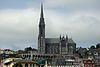
|
| 2 | St Mary's Cathedral | Killarney | cathedral | 1912 | 86.8 m (285 ft) | 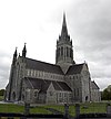
|
| 3 | St Patrick's College Church | Maynooth | church | 1891 | 83 m (272 ft) | 
|
| 4 | St John's Cathedral | Limerick | cathedral | 1861 | 81 m (266 ft)[1] | 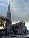
|
| 5 | St Anne's Cathedral | Belfast | cathedral | 1904 | 80 m (260 ft)[2] | 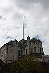
|
| 6 | St Eugene's Cathedral | Derry | cathedral | 1903 | 78 m (256 ft) | 
|
| 7 | St Macartan's Cathedral | Monaghan | cathedral | 1893 | 74 m (243 ft) | |
| 8 | St Finbarre's Cathedral | Cork | cathedral | 1879 | 73 m (240 ft) | 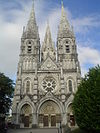
|
| 9 | St Eunan's Cathedral | Letterkenny | cathedral | 1900 | 73 m (240 ft) | 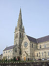
|
| 10 | Cathedral of Saint Patrick and Saint Felim | Cavan | cathedral | 1942 | 70 m (230 ft)[3] | 
|
| 11 | St Peter and St Paul Cathedral | Ennis | cathedral | 1874 | 69 m (226 ft) | 
|
| 12 | Sacred Heart Church | Omagh | church | 1899 | 68.6 m (225 ft) | 
|
| 13 | Church of Saints Augustine and John | Dublin | church | 1874 | 68 m (223 ft) | 
|
| 14 | St. Peter's Roman Catholic Church, Drogheda | Drogheda | church | 1884 | 67.66 m (222.0 ft) | 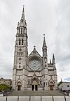
|
| 15 | St Columb's Cathedral | Derry | cathedral | 1633 | 67 m (220 ft) | 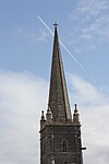
|
| 16 | St Patrick's Cathedral (Church of Ireland) | Dublin | cathedral | 1191 | 66 m (217 ft) | 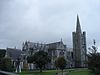
|
| 17 | St Patrick's Cathedral (Roman Catholic) | Armagh | cathedral | 1904 | 64 m (210 ft) | 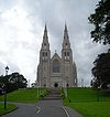
|
| 18 | St Patrick's Church (Roman Catholic) | Belfast | church | 1877 | 63 m (207 ft)[4] | 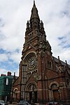
|
| 19 | St George's Church | Dublin | church | 1813 | 61 m (200 ft) | 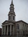
|
| 20 | St. Marys Church of Ireland | Carlow | church | 1834 | 59.5 m (195 ft)[5] |
Tallest structures[]
| Name | Location | Year completed | Pinnacle height | Pinnacle height | Type | Coordinates | Remarks |
|---|---|---|---|---|---|---|---|
| Strabane transmitting station | Legfordrum (near Strabane), County Tyrone | 1963 | 305.5 m | 1,002 ft | Guyed mast | 54°47′58″N 7°23′19″W / 54.79944°N 7.38861°W | |
| Tullamore radio mast | Tullamore, County Offaly | 1975 | 290 m | 951 ft | Guyed mast | 53°16′42.29″N 7°22′18.44″W / 53.2784139°N 7.3717889°W | Insulated against ground, used until 2008 for broadcasting on 567 kHz |
| Clarkstown radio transmitter | Summerhill, County Meath | 1988 | 248 m | 813 ft | Guyed mast | 53°27′45.53″N 6°40′39.32″W / 53.4626472°N 6.6775889°W | Insulated against ground, used for broadcasting on 252 kHz |
| Black Mountain transmitting station | Hannahstown, County AntrimBelfast | 1959 | 228.6 m | 750 ft | Guyed mast | ? | |
| Mullaghanish transmitter | Mullaghanish mountain, County Cork | 1962 | 225 m | 738 ft | Guyed mast | 51°59′29″N 9°8′42″W / 51.99139°N 9.14500°W | |
| Moneypoint Power Station Chimneys | Moneypoint, County Clare | 1985 | 218 m | 715 ft | Chimney | 52°36′29.16″N 9°25′31.85″W / 52.6081000°N 9.4255139°W ; 52°36′27.68″N 9°25′24.7″W / 52.6076889°N 9.423528°W | |
| Poolbeg power station, Chimney 2 | Poolbeg, Dublin | 1978 | 207.8 m | 682 ft | Chimney | 53°20′24.84″N 6°11′19.38″W / 53.3402333°N 6.1887167°W) | |
| Poolbeg power station, Chimney 1 | Poolbeg, Dublin | 1970 | 207.48 m | 681 ft | Chimney | 53°20′24.82″N 6°11′23.79″W / 53.3402278°N 6.1899417°W | |
| Kilroot power station chimney | Kilroot (near Carrickfergus), County Antrim | 1981[6] | 198 m | 650 ft | Chimney | 54°43′28.25″N 5°46′2.15″W / 54.7245139°N 5.7672639°W | |
| Truskmore transmitter | Sligo, County Sligo | ? | 167.64 m | 550 ft | Guyed mast | 54°22′22.57″N 8°22′15.32″W / 54.3729361°N 8.3709222°W | |
| Divis transmitting station | Hannahstown, County Antrim
Belfast |
1955 replaced and made taller in 2011 | 166 m | 545 ft | 53°36′27″N 6°00′34″W / 53.60750°N 6.00944°W | Was 141.7 m but replaced in 2011
Note these are a pair of twin masts. | |
| Three Rock transmitter | Dublin | 2002 | 152.4 m | 500 ft | Guyed mast | 53°14′39.98″N 6°14′17.33″W / 53.2444389°N 6.2381472°W | |
| Aghada Power Station Chimney | Cork | ? | 152 m | 499 ft | Chimney | 51°50′6.05″N 8°14′9.41″W / 51.8350139°N 8.2359472°W | |
| Tarbert Power Station, Chimney of Unit 3 and 4 | Tarbert, County Kerry | 1975 | 151 m | 497 ft | Chimney | 52°35′24″N 9°21′46″W / 52.59000°N 9.36278°W | |
| Lisnagarvey transmitting station | Magherageery (near Lisburn), County Down | 1936 | 145 m | 476 ft | Guyed mast | 54°29′22″N 6°3′37″W / 54.48944°N 6.06028°W | It was 145 m when built, but has since been lowered in height to 99m |
| Greystones Wind farm | Greystones, County Wicklow | 139.29 m | 457 ft | Wind turbines | 53°10′18.10″N 6°01′30.00″W / 53.1716944°N 6.0250000°W | ||
| Great Island Power Station Chimney | Wexford, County Wexford | 138 m | 453 ft | Chimney | 52°16′43.82″N 6°59′37.76″W / 52.2788389°N 6.9938222°W ; 52°16′43.71″N 6°59′35.95″W / 52.2788083°N 6.9933194°W | ||
| Kippure transmitter | Kippure mountain, border of County Dublin and County Wicklow | 1961 | 127 m | 416 ft | Guyed mast |
53°10′40.93″N 6°19′53.82″W / 53.1780361°N 6.3316167°W || [7] | |
| Ballylumford Power Station Chimneys | Islandmagee, County Antrim | 1974 | 126 m | 413 ft | Chimney | 54.845 n5.787w | |
| Kinnegad Cement Factory Chimney | Meath | ? | 125.3 m | 411 ft | Chimney | 53°25′52.84″N 7°08′33.78″W / 53.4313444°N 7.1427167°W | |
| Arklow Bank Wind Park | Wicklow, County Wicklow | ? | 124 m | 407 ft | Wind turbines | 52°47′28.00″N 5°56′48.00″W / 52.7911111°N 5.9466667°W | Offshore wind farm |
| Mount Leinster transmitter | Mount Leinster, County Carlow/County Wexford | ? | 122 m | 400 ft | Guyed mast | 52°36′59″N 6°46′30″W / 52.61639°N 6.77500°W | [8] |
| Maghera transmitter | Maghera mountain, County Clare | ? | 121.92 m | 400 ft | Guyed mast | 52°58′6.9″N 8°43′6.89″W / 52.968583°N 8.7185806°W | [9] |
| Cairn Hill transmitter | Cairn Hill, County Longford | ? | 121.92 m | 400 ft | Guyed mast | 53°48′28″N 7°42′52″W / 53.80778°N 7.71444°W | [10] |
| Cork mediumwave transmitter | Cork | 1970 | 121.92 m | 400 ft | Guyed mast | 51°52′57.05″N 8°23′58.46″W / 51.8825139°N 8.3995722°W | Insulated against ground, used for broadcasting on 729 kHz |
| Tarbert Power Station, Chimney of Unit 1 and 2 | Tarbert, County Kerry | 1969 | 121 m | 397 ft | Chimney | 52°35′24″N 9°21′46″W / 52.59000°N 9.36278°W | |
| Kilgarvan Wind farm | Kilgarvan, County Kerry | ? | 120 m | 394 ft | Wind turbines | 51°55′58.80″N 9°19′20.95″W / 51.9330000°N 9.3224861°W | |
| Spire of Dublin | Dublin | 120 m | 394 ft | Monument | 53°20′59″N 6°15′37″W / 53.34972°N 6.26028°W) | ||
| Donnybrook transmitter | Dublin | ? | 109.7 m | 360 ft | Lattice tower | 53°18′53.13″N 6°13′24.88″W / 53.3147583°N 6.2235778°W | |
| Moanvaun Wind farm | Tipperary, County Tipperary | ? | 107.3 m | 352 ft | Wind turbines | 52°38′44.80″N 8°08′54.44″W / 52.6457778°N 8.1484556°W | |
| Aughinish Alumina Plant Chimney | Limerick, County Limerick | ? | 107 m | 351 ft | Chimney | 52°37′53.64″N 9°03′32.37″W / 52.6315667°N 9.0589917°W | |
| Kiln Cement Factory | Limerick, County Limerick | ? | 107 m | 351 ft | Chimney | 52°38′33.92″N 8°41′23.72″W / 52.6427556°N 8.6899222°W | |
| Samson | Harland and Wolff, Belfast | 106 m | 348 ft | Crane | 54°36′29″N 5°54′29″W / 54.60806°N 5.90806°W | ||
| Klin of Platin Cement Factory | County Meath | ? | 103.9 m | 341 ft | Klin | 53°41′6.58″N 6°23′19.85″W / 53.6851611°N 6.3888472°W | |
| Ballywater Wind Farm | Wexford, County Wexford | ? | 103 m | 338 ft | Wind turbines | 52°32′25.92″N 6°13′40.29″W / 52.5405333°N 6.2278583°W | |
| Athlone transmitter | Athlone, County Westmeath | 1933 | 100 m | 328 ft | Guyed Mast | 53°25′14.14″N 7°52′45.87″W / 53.4205944°N 7.8794083°W ; 53°25′14.09″N 7°52′58.43″W / 53.4205806°N 7.8828972°W | Two guyed masts insulated against ground carried a T-antenna for broadcasting on 612 kHz. One of the two masts dismantled in 2011 |
| Codling Banks Mast | Wicklow, County Wicklow | 100 m | 328 ft | Guyed Mast | 53°07′44.87″N 5°50′49.54″W / 53.1291306°N 5.8470944°W | Offshore structure | |
| Coreen Wind farm | Cavan, County Cavan | ? | 100 m | 328 ft | Wind turbines | 54°08′32.27″N 7°38′38.60″W / 54.1422972°N 7.6440556°W | |
| Snugborough Wind farm | Cavan, County Cavan | ? | 100 m | 328 ft | Wind turbines | 54°08′21.27″N 7°36′38.14″W / 54.1392417°N 7.6105944°W | |
| Gartnaneane Wind farm | Cavan, County Cavan | ? | 100 m | 328 ft | Wind turbines | 53°56′43.67″N 6°56′08.24″W / 53.9454639°N 6.9356222°W | |
| Coomatallin Wind farm | Cork, County Cork | ? | 100 m | 328 ft | Wind turbines | 51°39′03.62″N 9°5′38.87″W / 51.6510056°N 9.0941306°W | |
| Meentycat Wind farm | Cork, County Cork | ? | 100 m | 328 ft | Wind turbines | 54°51′46.19″N 7°51′12.62″W / 54.8628306°N 7.8535056°W | |
| Beal Wind farm | Wicklow, County Wicklow | ? | 100 m | 328 ft | Wind turbines | 52°33′47.33″N 9°37′55.73″W / 52.5631472°N 9.6321472°W | |
| Beam Wind farm | Kerry, County Kerry | ? | 99 m | 325 ft | Wind turbines | 55°11′51.98″N 7°26′16.32″W / 55.1977722°N 7.4378667°W | |
| Goliath | Harland and Wolff, Belfast | 96 m | 315 ft | Crane | 54°36′29″N 5°54′29″W / 54.60806°N 5.90806°W | ||
| Mount Eagle Wind farm | Donegal, County Donegal | ? | 95.7 m | 314 ft | Wind turbines | 52°14′33.15″N 9°19′26.22″W / 52.2425417°N 9.3239500°W | |
| Mweelin TV Mast | Achill Island, County Mayo | ? | 91.44 m | 300 ft | Guyed mast | 53°57′19″N 10°1′42.45″W / 53.95528°N 10.0284583°W | |
| Dún Laoghaire Cranes | Dublin | ? | 91.4 m | 300 ft | Crane | 53°17′40.87″N 6°7′53.73″W / 53.2946861°N 6.1315917°W | |
| Bealadangan Radio Mast | Galway | ? | 91.4 m | 300 ft | Partially guyed tower | 53°18′36.84″N 9°36′30.23″W / 53.3102333°N 9.6083972°W | Was used for RTÉ RnaG, now dismantled |
| Cark Wind farm | Donegal, County Donegal | ? | 91.1 m | 299 ft | Wind turbines | 54°53′06.20″N 7°51′33.12″W / 54.8850556°N 7.8592000°W | |
| Greenoge Wind farm | Wexford, County Wexford | ? | 90.2 m | 296 ft | Wind turbines | 52°39′28.23″N 6°43′31.69″W / 52.6578417°N 6.7254694°W | |
| Dublin Airport ATC Tower | Collinstown, Fingal | 2019 | 86.9 m | 285 ft | Air traffic control tower | 53°25′44.3″N 6°15′50.8″W / 53.428972°N 6.264111°W |

Other categories[]
Entries in the list that are in Northern Ireland are denoted by an asterisk, the others being in the Republic of Ireland.
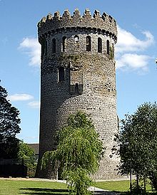
Nenagh Castle Keep
- Sculptures
- Spire of Dublin, 120 m (394 ft)
- Spire of Hope, St Anne’s Cathedral, Belfast*, 80m (262 ft)
- Gantry Cranes
- "Samson", Harland and Wolff, Belfast*, 106 m (348 ft)
- Bridges
- River Suir Bridge, Waterford, 100 m (330 ft)
- Boyne River Bridge, 95 m (312 ft)
- Windmills
- Kilgarvan Wind Farm (group of 14 wind turbines), 93 m (305 ft)
- Obelisks
- Wellington Monument, Phoenix Park, 63 m (207 ft) (Tallest in Europe)
- Lighthouses
- Fastnet Rock Lighthouse, 44.5 m (146 ft)
- Stadiums
- Croke Park, 40 m (131 ft)
- Air traffic control towers
- Dublin Airport ATC Tower, 86.9m
- Moving sculptures
- Irish Wave, Park West, Dublin, 35.4 m (116 ft) (Tallest in Europe)
- Round towers
- Kilmacduagh monastery, 34 m (112 ft)
- Castles
- Nenagh Castle Keep, 31 m (102 ft)
- Standing stones
- Punchestown, 6.5 m (21 ft)
- High crosses
- Muiredach's High Cross, Monasterboice, 6.45 m (21 ft)
Former[]

Former Churchill House, Belfast
- Bellacorick Cooling Tower, 89 m (290 ft), demolished 2007
- Arrol Gantry, 70 m (228 ft), demolished 1969
- Churchill House, Belfast, 66 m (215 ft), demolished 2004
- Boyne Obelisk, 53 m (174 ft), destroyed 1923
- Ballymun Flats, 42 m (136 ft), demolished 2004-2015
- Nelson's Pillar Monument, 41 m (134 ft), destroyed 1966
- Walker's Monument, 32 m (105 ft) destroyed 1973
See also[]
- List of tallest buildings in Ireland
- List of tallest buildings and structures in Belfast
- List of tallest buildings and structures in Dublin
References[]
- ^ "St John's Cathedral | Limerick.ie". www.limerick.ie. Retrieved 2020-11-12.
- ^ "Belfast Cathedral". belfastcathedral.org.
- ^ Cavan Cathedral - Kilmore Diocese
- ^ "St Patrick's Church, Belfast". Emporis.com. Retrieved 2011-02-22.
- ^ "Carlow Town Walk". carlowtourism.com. Retrieved 2020-10-02.
- ^ "Chimney of Kilroot power station". Emporis. Retrieved 2020-09-12.
- ^ "Archived copy". Archived from the original on 2011-05-19. Retrieved 2010-12-08.
{{cite web}}: CS1 maint: archived copy as title (link) - ^ "Archived copy". Archived from the original on 2011-07-26. Retrieved 2010-12-08.
{{cite web}}: CS1 maint: archived copy as title (link) - ^ "Archived copy". Archived from the original on 2012-03-15. Retrieved 2012-11-06.
{{cite web}}: CS1 maint: archived copy as title (link) - ^ "Archived copy". Archived from the original on 2011-07-26. Retrieved 2010-12-08.
{{cite web}}: CS1 maint: archived copy as title (link)
Other sources[]
- Tallest structures in Ireland
- Galloway, Peter; Cormac Simms (1992). The Cathedrals of Ireland. Dublin: Institute of Irish Studies. ISBN 0-85389-452-3.
- "Punchestown Standing Stone Standing Stone / Menhir – The Modern Antiquarian.com". Themodernantiquarian.com. 2006-01-14. Retrieved 2017-06-13.
- "Irish Wave". The Daily Telegraph. Archived from the original (XML) on 2003-12-07. Retrieved 2017-06-13.
- "Diagrams". SkyscraperPage.com. Retrieved 2017-06-13.
- "Dublin City Council". Dublincity.ie. Retrieved 2017-06-13.
Categories:
- Lists of tallest structures by country
- Lists of buildings and structures in Ireland